Hawkesbury River

The Windsor Paddlesports Club Grant saved after hanging by a thread!


I am also informed that (belatedly) the Council has confirmed the necessary "landowner consent" from Crown Lands.
The grant is not out of the woods yet, as there remains the question of whether the facility can be built within the grant monies pledged.
I will continue to advocate for a good outcome for the community.

Should development be allowed on our floodplain?

Two stories appearing recently in the media criticise Hawkesbury Council for approving DA’s on flood-prone land.
I have been flagging concerns over the statistical inevitability of another serious flood for a decade before my election to Council in 2016.
My support for raising Warragamba dam has always been paired with a demand for more stringent controls on floodplain development. There is no value in capital works for mitigation if we succumb to the temptation to lower the 1:100 limit or intensify urbanisation in areas subject to flood or flood evacuation risk.
The current ‘1:100’ dwelling-height limit of 17.3m at Windsor was introduced in the 1980s. 5000 dwellings already lay along the floodplain below that limit. They were built before flood-height controls existed. Some are in the most historic areas of Windsor and Pitt Town. Others lay low along the river at locations now perceived by everyone (including insurers) as high-risk, like caravan parks.
Some of the approvals reported in the media may be for the reconstruction of dwellings in that category and where an ‘existing use right’ is asserted, even though any new dwelling would never be approved under the current standards. Whether to permit a rebuild is a fraught issue.
Other approvals may be for new development on land that is partly below and partly above the 1:100 limit, and where the floor height of development is confined to the land laying above the limit. It’s legitimate to debate about whether this policy should be readdressed, but flood height controls are not at the discretion of Council; they are State-mandated standards that our Council follows.
‘Buy-backs’ like we’ve seen in Lismore should be on the table, and it’s frustrating that a policy offered in one area of the state is denied to ours where there is arguably greater risk.
Another solution would be to permanently change flood-height controls from the 1:100 limit to a higher one, such as the PMF (Probable Maximum Flood) which is 26.4m at Windsor.
However, we must ask at what cost these measures come. Government policies send signals to insurers. Many residents in established and historic areas of our most beautiful towns are now paying insurance premiums of tens of thousands of dollars and face invidious choices: living uninsured, going broke, or selling up at reduced value, when their houses were duly approved under the laws of the day.
Raising the flood-height limit or buying-and-demolishing existing properties would potentially raze some of our most beautiful, historic and heritage-listed suburbs. The height of the PMF is literally over the roof of the Macquarie Arms Pub in Windsor, meaning if the PMF was the applicable standard, none of Windsor would exist. This is nonsense. None of these outcomes are good enough.
Council’s response includes the adoption of a range of documents, including the recent Local Approval Policy for Caravan Parks (2023), a Flood Policy (2020, amended 2021) the Schedule of Flood Related Development Controls (2021), a Flood chapter in our new DCP (pending), and the Regional Flood Mitigation in the Hawkesbury-Nepean Valley Policy (2011).
Fundamentally, Council must adhere to the current legislative framework which has been gazetted by the State Government. Council is over-ridden by State policy on many fronts. If the State Government changes the development standards relating to flooding requirements then Council will ensure that future development in those areas will adhere to those requirements.
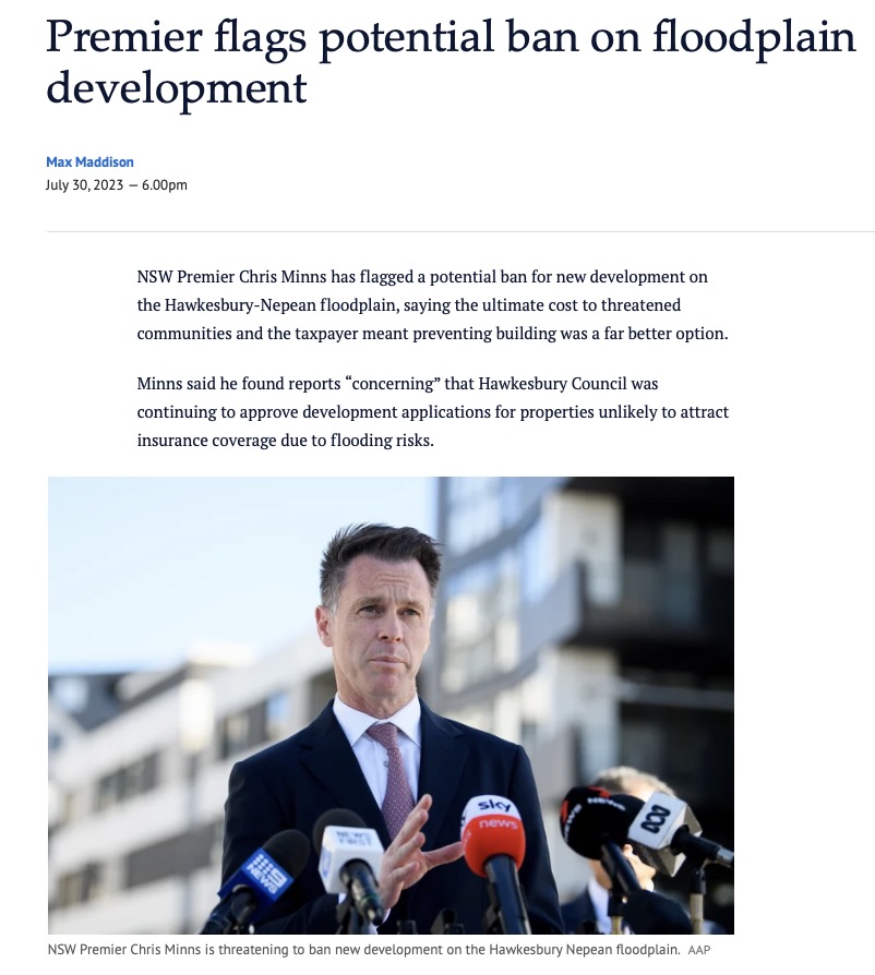
In my opinion the new State government have abandoned Hawkesbury residents by failing to declare what mitigation measures they intend to fund now raising Warragamba has been ruled out – the second such time Labor has done so since 1996. The NSW Premier Chris Minns has even refused to visit the Hawkesbury to explain when and how he will fulfil pre-election promises on measures like levees, and Hawkesbury's Labor candidate Amanda Kotlash even voted against a motion brought by the Mayor to ask the Premier to visit, which is crazy!
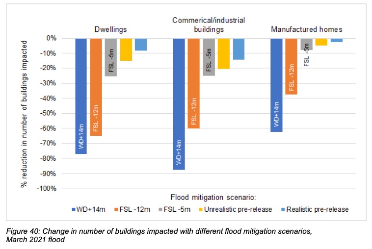
It remains undisputed that if the dam had been raised already, 80% of the 600+ dwellings that were inundated in the recent floods would have been spared completely owing to the flood-peak being 3.4-5.3m lower (p66 of the report). If alternative strategies can’t confer the same or better degree of mitigation, they should admit it and return to raising Warragamba Dam as the best option.

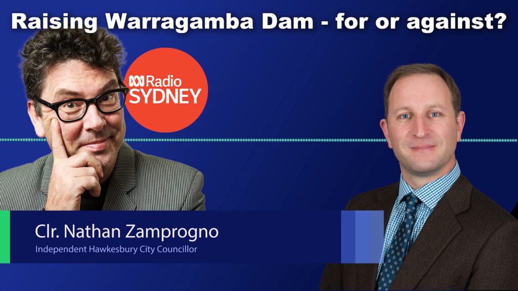
Should we lower Warragamba Dam instead of raising it?
Last week Council met for the first time since the July floods. The Mayor advanced a motion that calls on the State Government to change legislation regulating the operation of Warragamba Dam to permit the Dam to be lowered in times of likely high-rainfall which will provide a degree of flood mitigation ability.
I supported the motion, but I want to be very clear that lowering the operating level of the dam is not a substitute for raising the dam wall, which remains the best way to properly mitigate floods. Lowering the dam level might have taken 20-60cm off the level of the flood. Raising the dam would have taken off 3.5 metres, based on the smaller March 2021 flood.
As I say here, climate change will deal us times of greater variability of weather in coming years. Longer periods of flood and longer periods of drought. The reductions being sought by some at our meeting last Tuesday would have let the whole dam run dry prior to the end of the last drought in February 2020. That's just as irresponsible. I see a lot of people advancing positions in the teeth of scientific evidence they're wrong, and that's no way for us to get to the best solution.
Whether to raise or lower the Dam was also the subject of an excellent story this week on Channel 9's A Current Affair.

The Hawkesbury-Nepean flood of July 2022 – the worst since 1978
July 5th 2022 represented the worst day of flooding in the Hawkesbury in 44 years.
This flood exceeded 13.93m, beating both the March flood (13.71m) and the 2021 flood (12.91m). You would have to go back to 1978 (14.5m) to see a worse flood. The 1867 flood was 19.6m. A "one in a hundred" flood is 17.3m, each measured at the Windsor gauge.
I toured the district, commiserated with locals, and took note of what I saw. This video represents the waters as they peaked. Councillors are being briefed daily by Council staff and we're proactive in guiding the response to the emergency.
I am reminded yet again how magnificently we stand by one another in times of trial. Our community is strong, and the only way we can get through this, is together.
There is one common misunderstanding that's worth clearing up, because I hear it very frequently.
Warragamba is not a flood mitigation dam. It was built as a water storage dam in 1960 and legally cannot be deliberately operated at below 100% capacity in the sense of dumping water overboard in anticipation of a rain event, or permanently operating it at a lower capacity. This is unlike other city dams like the Wivenhoe Dam in Brisbane which has a permanent 'air gaps' to act as a buffer in times of flood. Wivenhoe's water storage capacity is 1160 gigalitres but its air gap is a further 1967 gigalitres. IN other words, two thirds of its capacity is a flood buffer.
Warragamba's current capacity is 2031 gigalitres, and the plan to raise it by 14m will add about 1000 gigalitres of emergency storage.
Some have argued that the water level could be drawn down from 100% as the result of a long range forecast for rain, anticipating an East Coast Low for example. Others argue the permanent level of the dam should be lowered and that this is equivalent to the kind of mitigation that raising the dam would confer.
However, this would not confer a sufficient degree of mitigation to be worthwhile. And here's the analysis of flood hydrology that proves it:

If the dam level had been drawn down just before the 2021 flood, the resulting flood height would have been only 20cm lower.
If the dam was permanently kept lower by as much as 5m, it would have made a 60cm difference. Any more and Sydney's drinking water would be imperilled. Had the water supply been lowered by 5 metres in 2016 for example, the dam storage would have dropped to around 26% in February 2020 at the end of that drought – a critically low level, even lower than during the Millennium drought when the storage reached 32%.
If a raised dam had already been in place, 500 of the 600 houses flooded along the Hawkesbury-Nepean floodplain would have been spared since that flood would have been 3.5m lower. And in the events of still-larger floods, the degree of protection grows further.
Only raising Warragamba dam will confer the necessary degree of mitigation. I commend this Infrastructure NSW FAQ and also the NSW Government's post 2021 flood report for more information.

How the community rallied to clean up Pitt Town creeks after the floods
Two months ago I raised the terrible condition of Bardenarang Creek at Pitt Town after the March floods. Friendship Bridge there marks a significant historical site – the place of first meeting between Europeans and Aboriginals in the district in 1791.
Plastic sheeting and debris filled the creek and it was well beyond locals or Council to fix unless there was a significant collaboration of manpower and pooled resources.
It's heartening to see that help has arrived in the form of Disaster Relief Australia, who have combined with Hawkesbury City Council and the Pitt Town Progress Association to resource a four-day blitz on a substantial part of the creek. DRA are a Veteran-led volunteer organisation who help communities in distress at times like these.
I've long been a student of what resilient communities look like, and behold: A local residents group with volunteers and heavy equipment ready to help, Council ready to co-ordinate with skip bins and portaloos (and thanks to Council officer Phillip Bow for his role), and a group like Disaster Relief Australia who bring know-how and corporate philanthropy from the likes of NAB, Allianz, & Salesforce (and many others) contributing manpower and funding. This is the way.
We can only hope that we will not have to repeat this whole exercise again in the coming weeks as the threat of new floods loom over us. Some in our community have been knocked down more than once. Only with help like this can they continue to get back up.
On behalf of the Hawkesbury community, thank you to you all for your heart to help, for your muscle, for your smarts, and for your coin.

Sky News Australia special report into flooding on the Hawkesbury-Nepean River

However, raising Warragamba Dam is a necessary part of a larger strategy. In the Flood Emergency Plan our Council adopted in 2020, the maintenance of effective evacuation routes was listed as a critical priority.

The Hawkesbury-Nepean River Floods - March 2022
July 2022 update. It's flooding again. Again.
I have been talking about flooding on the Hawkesbury-Nepean river for many many years. If you've arrived at this page as the result of a Google search, please consider these resources:
• My more recent video and post about the July 2022 floods, with some very striking video
• All my output on this website about flooding.
• My YouTube channel. This link should prioritise my videos about flooding. Please subscribe.
Original March 2022 post:
Flooding has again struck our community for the second time in 12 months.
This flood has risen to 13.7m (as measured at Windsor - which tends to be the benchmark), beating last year's flood of 12.9m making it approximately a 1-in-20 year event.
This video was taken when the waters still had about 2 more meters to rise.
I'm indebted to the excellent Hawkesbury Flood Statistics facebook page for making excellent real-time data available about river heights and closures.
Here's their summary after the waters subsided:


On ABC Breakfast Radio about Warragamba Dam (again)

Hawkesbury Council rejects critical flood safety measure – Again!
Our community has known we have to 'Live with the River' since the time of settlement. Our relationship with the river and the inevitability of floods mean we're forever torn between the blessings of rich soils and the river's deadlier moods. My own ancestor was killed in Windsor in the flood of 1809.
But human ingenuity has given us the ability to dam rivers, and we're now told that raising Warragamba Dam by 14 meters will reduce the frequency and severity of flooding here by 75%. That it would reduce the number of homes flooded by 5000. That the damage bill would reduce by $3,000,000,000. We need that. If only we had it in March – it would have spared 500 homes and reduced the flood height by 3.5m.
The new EIS is open for public comment until the end of November. Here are all the EIS documents, and I strongly suggest you start with the Executive Summary, given that the whole EIS is 8092 pages long. Council would be completely negligent on behalf of our community, who endure the highest risk of flooding in Australia, if we didn't make a submission. Submissions run until the end of November. You should consider making a submission (look for the link in the top right corner)
I'm appalled that a majority of Councillors are so wedded to their ideology that, at last night's meeting, they voted even that down. The video above summarises what happened at the meeting.
That's right - they voted down even putting forward our own community's concerns in a document to the State Government.
I know not everyone agrees on this issue, but this is reckless and treats the 600 families whose homes were flooded out in March with contempt.
And yes, this absolutely should be an election issue.
I have of course been very, very active on the subject of flooding over this five-year term of Council: Here's a list of all my videos and motions before Council on this subject.

Hawkesbury Council's position concerning the new Hawkesbury River bridge
Last night Council considered the submission we would make to the consultation process on the route of the new Hawkesbury River crossing at North Richmond.
My position is guided by an awareness that this is not Council’s project. Like the Windsor Bridge project before, we neither decide nor craft its appearance, budget or timeline.
However, Council does have a role to listen to residents and then represent their concerns clearly. And other tiers of government, if they are wise, should listen. I’ve been contacted by dozens of residents and had long conversations both for and against the preferred ‘green route’.
I’m persuaded that the briefings conducted by Transport for NSW make a good case for the preferred ‘green route’. The modelling clearly shows it saves the greatest amount of travel time, is subject to fewer ‘major’ constraints, has a superior cost-benefit ratio compared to the purple route, will draw more traffic away from the already-congested current crossing, and will have a lower impact on the landscape in terms of earthworks, heritage and ecology.
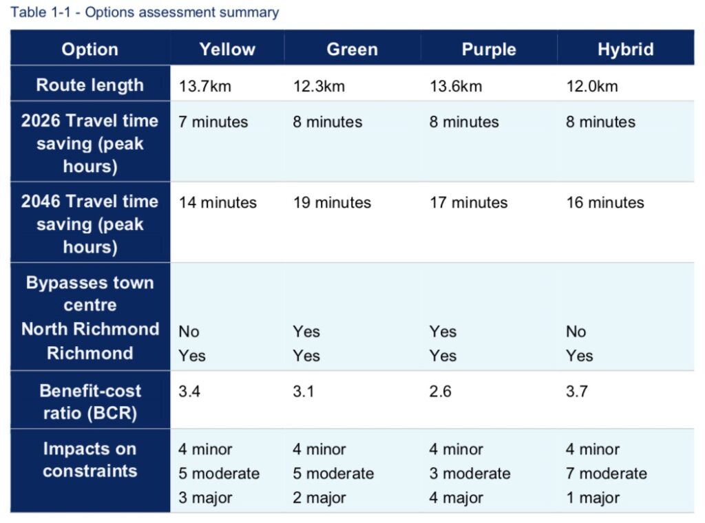
That said, there are still substantial unanswered questions before us, and many ways in which the proposed route could be improved. If we don’t ‘hustle’, the community won’t get what we deserve.
I remain concerned about the impacts on the residents of Hobartville, and especially on Southee Road and Inalls Lane.
I think the intersection of Kurrajong Road, Old Kurrajong Road and Yarramundi Lane should be an elevated flyover – not just to reduce traffic congestion, but to provide better flood resilience as well.
I’m happy for Council to acknowledge the strengths of the green route, but continue to press for investigations to continue into a hybrid green/yellow route – especially if that benefits the users of the playing fields on Yarramundi Lane.

Lastly, the community needs to know whether the status of the Grose River crossing – contractually bound on the Redbank developers, but much delayed and still no certainty, affects the modelling.
I am pleased that Councillors understood the need for a bipartisan approach on this, and with the exception of Councillor Ross (who votes against everything in what I regard as a very unconsidered attitude), we will be making something close to this submission.

Make no mistake - raising Warragamba Dam will make our community safer


Raising awareness of the need for Hawkesbury-Nepean River Health

The purpose of the visit was to raise awareness of river health, a responsibility I share as the Chairman of the Hawkesbury River County Council, which covers four Council areas and much of the river from Warragamba to Wiseman's Ferry.
We have specialised plant and equipment at HRCC which is essential to keep the river free of weeds, and were disappointed when the State Government pulled some key operational funding last year - just as we completed the salvage, refurbishment and recommissioning of our giant 'Weedosaurus' harvester with a $130,000 Federal grant.
My belief is that taxpayers, to say nothing of key river user groups like Rowing Australia, representing our Olympic team training on the river for the Tokyo games, expect the tiers of government to work together co-operatively to undertake this critical and ongoing work.
Minister Evans was a thoughtful listener and we gave him a detailed account of the effects of the floods earlier this year, the temporary reprieve it has given us as it flushed the river, and the short-sightedness of forcing us to sell our plant and equipment when weeds, like grass, will inevitably grow back. This is a warning I have delivered before.
The above story appears in this week's Western Weekender, and follows earlier coverage back in February.


The Hawkesbury Floods, March 2021
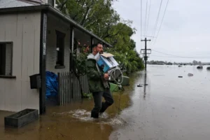
Some times it must feel like our community can't cop a trick. Devastating fires, pandemic and two floods, all within a 16 month period.
Yet again, out of the distress and destruction of property has arisen the real spirit of our local community, which has rallied magnificently. The response of our SES, Police and RFS have been truly heroic, and they deserve our respect, as do those who just help because it's the right thing to do. Neighbours help neighbours. It's the Hawkesbury way.
I tried to document the effects of and responses to flooding by visiting as many places and people as I could. These videos have apparently reached over 111,000 people on social media.
Since the waters have receded, I've been honoured to be present variously at the visits of the Governor General David Hurley, The Premier Gladys Berejiklian, Deputy Premier John Barilaro and Minister for Roads Andrew Constance.
It has also brought the need to raise Warragamba Dam back into focus.
The plan to raise the dam is about the safety of the community – the 134,000 people who live and trade on the Hawkesbury-Nepean floodplain. It isn't about development, or Sydney's drinking water supply. Nor should the debate be unduly focused on the temporary inundation of uninhabited bushland around lake Burragorang, for a week or two, once or twice a century.
The Resilient Valley, Resilient Community flood risk study released in 2017 explains 75% of our flood risk comes from the Warragamba catchment. It also points out that raising the dam would reduce the severity or frequency of bad floods by the same proportion – 75%.
Floods have already been averted or reduced by Warragamba, under certain circumstances. Severe rain events that began at the time of the early 1990s flood, when the dam was depleted to about 46% capacity, lowered the subsequent level of waters of on the floodplain by over three meters. This is the kind of 'accidental' mitigation that needs to be built into the dam permanently.
It really disappoints me that some of the commentary from people opposed to the project is so dishonest. This recent article in the Blue Mountains Gazette, and the comments of ex-Minister Bob Debus should anger everyone at risk of flooding, especially because he, like other opponents of the dam raising are usually high and dry and out of harms way. Our community in the Hawkesbury bears the brunt of this risk. I've pointed this out on many occasions.
Over the last fortnight I have stood with many people who have lost their homes and possessions because of Mr Debus' inaction in the 1990s, when there was a plan to raise the dam by 23m. The Labor government's decision not to treat this as a bipartisan issue and scotch those plans, which were shovel ready when Bob Carr was elected in 1995, is partly responsible for the damage this flood has caused.

Mr Debus says raising the dam won't prevent all floods. But wearing a seatbelt won't prevent all car accident fatalities. Backburning won't save every house in a bushfire. But only an idiot would argue against doing what we can.
Imagine if the present floods had been 3 meters lower as a result of being able to hold back 1000 gigalitres of that water for long enough to allow them to drain away.
When Mr Debus only notes the quarter of floods that result from rain in other tributaries, he's misleading you. And he's wrong to state that permanently lowering the dam levels by 10m is the same as raising them by 10m, because of the tapered shape of the dam. The bottom 2cm of a wine glass holds much less than the top 2cm.
And pre-emptively reducing water levels in the dam, which every armchair expert has advocated over the last fortnight would (literally) be a drop in the ocean.
The topical unit is the 'SydHarb' - A Sydney Harbour's worth of water, or about 500 gigalitres. Warragamba can hold 4 Sydharbs, and the dam raising project will add another 2. I was talking about this a decade ago. Lowering the dam to levels that would imperil Sydney's drinking water supply to create a buffer would have taken weeks, and would account for maybe 0.2-0.5 Sydharbs.
In comparison, the inflow of water resulted in a Sydharb *per day* topping the dam for 2-3 days. If we could have absorbed two days of that inflow and let it out over a week or fortnight, many of the grieving people who have lost their homes, goods or livelihoods would have been spared.
Lastly, Bob raises the debunked-a-thousand-times canard of development on the floodplain. The 1:100 flood height buildong controls will not change. Not a single square meter of land which is presently sterilised by these controls would be opened up for building in the event of raising Warragamba. And the only time any flood has exceeded the 1:100 level in the last 222 years was in 1867, showing this is a reasonable safety measure. The sad fact is that the 5,500 houses built below the 1:100 level were built before those flood height controls were implemented.
Damn you, Bob Debus, for your reckless conduct as a Minister - when you actually had a chance to do something about this, you sat on your hands.
I spoke to the media on several occasions to represent our at-risk community
Print stories: Central News (18-11-2020), ABC (27-3-2021), AAP (23-3-2021), and TV as below:
It concerns me that in each of these cases, the voice of the community at most risk is not emphasised in balancing the costs and benefits of flood mitigation.
An excellent book I have at home on the history of the construction of Warragamba Dam in the 1950s is subtitled "Thank God there were no greenies." I worry that an inability to soberly judge the necessity of flood mitigation will eventually cost lives, when a flood bigger than this one finally comes.
Nature has given us a warning. Are we wise enough to heed it?

Hawkesbury-Nepean river suffers as HRCC endures cut to funding

As the Chairman of the Hawkesbury River County Council, I believe Hawkesbury residents get great value out of our association with it, which goes back to the HRCC's founding in 1948. HRCC looks after the health of our waterways. Ratepayers from the four member Councils contribute around 50%, which is ~$190K per year towards its operations. The rest comes from a variety of State and Federal grants.
In November, Local Land Services, a mid-level bureaucracy installed by the NSW Government to dispense funding, abruptly cut the funding that we were using for operational works (such as weed clearing on the river using our 'Weedasaurus', pictured above), by $238,000. Before LLS, we dealt directly with the Department of Primary Industries (DPI) and had a wonderful working relationship with them.
This will result in us laying off skilled staff, and potentially even having to sell the Weedasaurus, which would be frustrating given we only had it repaired and refurbished with $130,000 of Federal money after it pulled its mooring and sank near Penrith weir in the flood of 2020.
We have Olympic and Paralympic rowers training on the river now for the Tokyo Olympics. They are counting on us to keep the river free of weeds. Taxpayers expect better co-operation between tiers of government. How ridiculous to have the Federal Government generously fund plant and equipment only to find that the State Government drops the ball with operational funding.
I am calling on the State Agriculture Minister, Adam Marshall, to intervene.

Re-elected as Chair of the Hawkesbury River County Council
I was honoured this week to be re-elected as the Chairman of the Hawkesbury River County Council for a second, one year term.
This is a great honour. I am the first Hawkesbury Liberal Councillor ever to be elected to this role, let alone re-elected. It's been a challenging year, with most of our meetings still occurring via Zoom. Balancing the welfare of staff with maintaining on-the-ground operational capacity has not been easy.
The HRCC covers 3,823sq.km over four municipalities (Hills, Blacktown, Penrith and Hawkesbury). It has responsibility for waterway health through the control of weeds, and increasingly takes a role in terrestrial weed control as well under the Biosecurity Act.
In this last year alone it conducted 3,949 property inspections. With its specialised assets like weed harvesters, and using new and innovative techniques like biological control (Salvinia eating Weevils, anyone?), it plays a major role in caring for our local environment.
I thank outgoing Deputy Chair, Robyn Preston MP - Member for Hawkesbury for her work with the Board, and congratulate Hills Shire Councillor Samuel Uno for his election as the new Deputy Chair.

Being cavalier about community safety -- elected representatives should support Warragamba flood mitigation works
Recently, the Federal Member for Macquarie, Susan Templeman MP has made remarks opposing the raising of Warragamba Dam for flood mitigation purposes. I am disappointed that any elected representative of a floodplain like ours would oppose such a crucial safety initiative.
This has been reported in the local media:
My own statement relating to this issue is below:

What are the facts about raising Warragamba Dam?
In any given year, what are the risks of your house burning down, you getting sick, or you crashing your car?
Low, I hope. These events have a low probability, but serious consequences. So we weigh the risk, and take out insurance.
So it is with our floodplain. There have been 124 floods in the Hawkesbury-Nepean since the 1790s. We had one this year (a baby -- between 1:5 and 1:10 probability), and worse ones are a statistical inevitability.
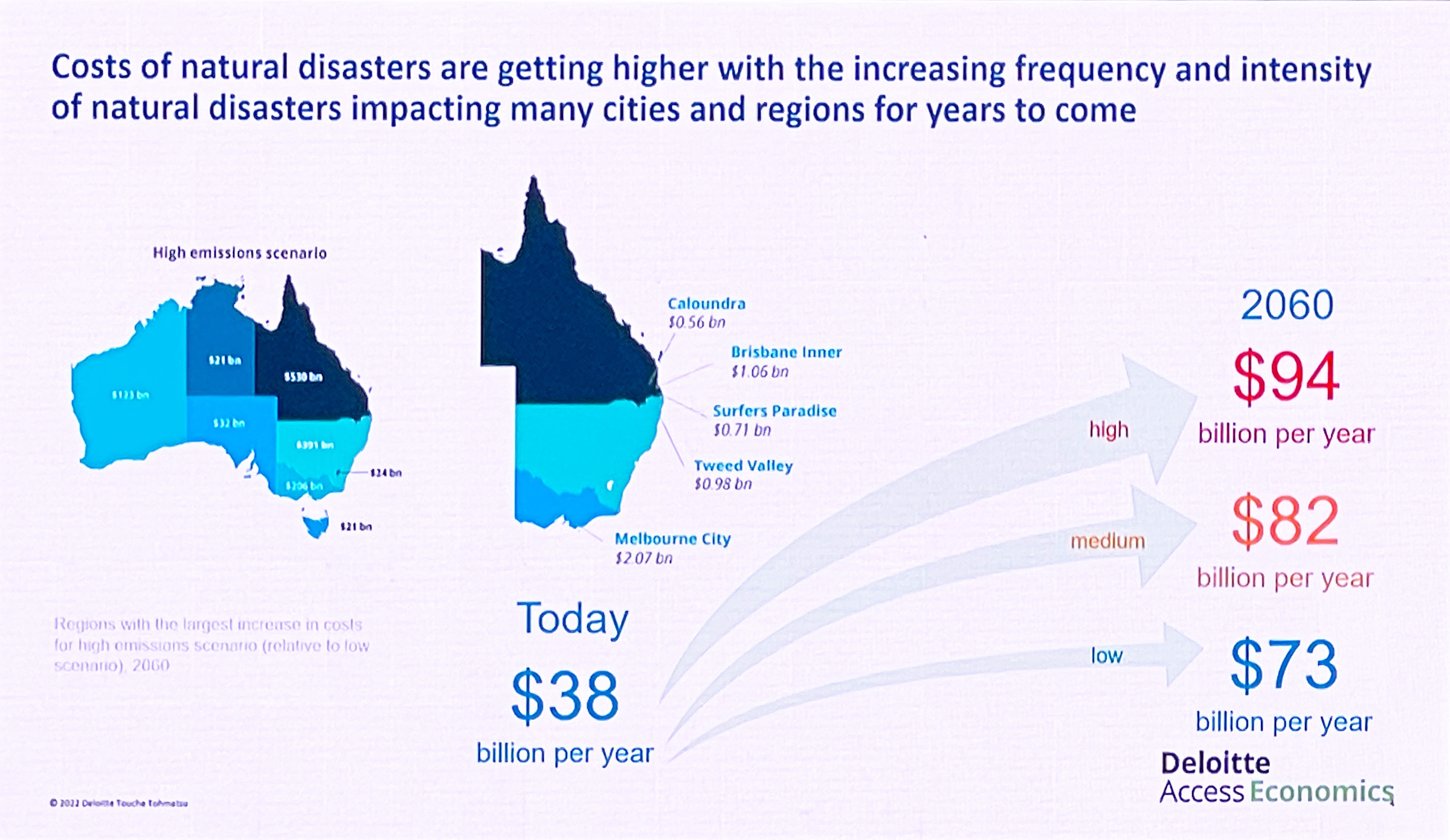
The NSW Government 2017 report, Resilient Valley, Resilient Communities says that the damage of a bad flood could be between $5 billion and $7 billion dollars, considering that 134,000 people live and trade on the floodplain.
In a bad flood, 90,000 of those people would need to be evacuated. 12,000 homes would be inundated.
The report also says that this risk could be reduced by 75% if Warragamba Dam is raised by 15 meters, saving lives and slashing $5 billion from the damage bill. A wise investment, I think.
The cost would be that, in those rare rainfall events, a fringe of land around the current high waterline of Lake Burragorang would be subjected to temporary inundation, amounting to 0.04-0.05% of the Greater Blue Mountains World Heritage Area. Crucially, preliminary modelling suggests the most sensitive areas of the catchment, like the Kowmung River and its tributaries, would not be affected at all.
There is a lot of misinformation put about concerning the Warragamba Dam raising project. That it's a stalking horse for development on the floodplain. That it will ruin a world heritage site. That it's about increasing Sydney's water supply.
These claims are not true -- even though these issues are important. The project is about protecting life and property. I observe that most people who are opposed to the project don't live on the floodplain. They live elsewhere, high and dry. They endure no risk to themselves, their families, or property. They are entitled to their views, but have no stake in the outcome.
The attached video is an interview I did recently when I was approached by someone doing some academic research from my alma mater, the University of Sydney. I summarise many of the points I frequently make about the project, and Hawkesbury Council's attitude towards it.
I've written about this subject many times before:

On the opening of the new Windsor Bridge

The new Windsor bridge opened to traffic this weekend. This is a major milestone, and the project has dominated local politics for a decade.
After so much Ill-feeling and unnecessary delay, I think this is a project the whole community should be proud of, and I say this as a local representative who felt very much caught in the middle by those passionately advocating for and against.
I didn’t entirely agree with those who thought of this project as a rape of Windsor’s heritage. But I did agree that building a replacement bridge in the same location condemned a very historic square to another century of heavy traffic, when it offered a wonderful opportunity to build a bypass. I said then and still say that this was a missed opportunity.

I also disagreed strongly with those who put out misinformation — saying for example that heritage buildings around Thompson square were “scheduled for demolition” when they never were, and the protesters knew that. They also said that historic brick barrel drains that had been covered up over a century would be destroyed, when in fact the project afforded the chance to do some unique archeology and then cover them back up, just like they have been all this time. We now have a documentary record and a host of artefacts we never would have otherwise had. Piers for the new bridge were moved so that they didn’t disturb the drains.

Nor did I see overwhelming merit in retaining a narrow, inadequate bridge whose visible structure was an ugly concrete deck added in 1924. The oldest part of the bridge, best able to be described as having heritage value, were the iron pillars driven into the river bedrock in 1874 — some of which will be retained in the construction of a viewing platform (which the protesters opposed!)
These things inflamed passions and tested friendships needlessly.
Of course, any protest started by people who care deeply about heritage or local amenity also attract carpetbaggers — people who care less about the issue, but who beadily seized an opportunity to create political friction for their own ends.
For years, I saw protests in Thompson Square with unsavoury types loitering around the edges — leather clad union thugs, federal politicians who had nothing to do with the project, Greens activists, even the late Jack Mundey, former BLF tsar and Communist Party candidate (but otherwise the saviour of The Rocks — see, people aren’t all bad).
It became a circus. At the last election, at least three people gained election to Hawkesbury Council on the back of this tide of protest, only to spend the last four years sticking their heads in the sand, opposing reasonable collaboration between Council and the RMS, and almost guaranteeing that the community input they sought election on would rarely reach the right ears. It’s been very frustrating.
I think many people who genuinely care about heritage have been used.
It’s worth noting that today's opening of the new bridge isn’t the end of the project. I’m hopeful that the completed landscaping will reunite the sundered halves of Thompson Square caused by the cutting dug in 1934, greatly expanding the useful space to the public, and underlining that Thompson Square has been a changing and evolving space since the beginning.

I’m confident that once everyone sees the completed project, people will reconsider whether all the noise and hand-wringing were worth it.
Hawkesbury, enjoy your new bridge. Maybe your great-great grandchildren will fight to preserve it as a piece of the area’s heritage in 2166, the year in which it will be as old as the current bridge retired at.
This video, courtesy of Robyn Preston MP - Member for Hawkesbury is a fascinating record of the bridge's construction.

Interviewed on ABC Sydney Radio about Warragamba Dam
Overnight, former Labor politician Bob Debus addressed a gathering of UNESCO in Baku, Azerbaijan, to seek their support in opposing the raising of Warragamba Dam.
This morning, ABC Sydney Radio asked to interview me to provide a response.
Here's the audio. I repeat the argument I've made many, many, many, many, many times before.


Funding for a new crossing of the Hawkesbury River

June 7th 2021 Update: This morning the Prime Minister and the Premier announced that funding for this project has been lifted to $500 million. The NSW Transport Minister Andrew Constance said that the new bridge will be 6m higher than the current bridge. The funding will be 80% from the Federal Government and 20% from the NSW Government. This is tremendously good news, along with confirmation that the project will not dump traffic into the already-congested heart of North Richmond but rather bypass North Richmond and join Bells Line of Road at Crooked Lane. This map has been circulating this morning as a preferred (note: not final) route.

I note that Susan Templeman the Labor Federal MP has chimed in pre-emptively this morning to claim credit for this announcement. I thought my remarks on that question I made two years ago remain just as relevant today.
Original 2-4-2019 post:
Yesterday, the Federal Liberal government committed $200 million to build a new road crossing of the Hawkesbury River.
This is tremendously exciting news, but some commentary I've seen is misleading about about who to thank and where we go from here.
The need for traffic congestion relief for residents west of the river has been understood and acknowledged for years. A walk through the timeline will be instructive.
In 2011, the newly elected Liberal State government commissioned a study, which delivered its "Long Term Options Report" in September 2012 and canvassed a number of options. These included:
- Amplifying the current bridge to three lanes and employing a contraflow arrangement morning and evening.
- Constructing a new two-lane bridge immediately downstream to provide an extra two lanes, either at the same level as the current bridge, or somewhat further downstream and at a higher level to provide 1:20yr flood immunity.
Each of these options would ultimately increase traffic through both Richmond and North Richmond and would require substantial amplification to roadworks between the Bosworth St intersection in Richmond, and the Grose Vale Road intersection in North Richmond.
In 2011, the then Labor Federal government pledged a paltry $2M -- money that did not appear in the budget or the forward estimates until 2015. The then Liberal Macquarie MP Louise Markus drew attention to this, saying
"(It's) another empty promise that may never eventuate. Heavy peak traffic on Grose Vale Road, Terrace Road and Bells Line of Road leading down towards the M7 causes significant congestion around the Richmond bridge. It takes sometimes more than an hour for people, once they reach North Richmond, to cross the bridge to Richmond on the way to work, and the same can happen in the evening."
By August 2014, the Federal Liberal-National government was in position to advance the issue. Louise Markus told the House of Reps:
The provision of safer, more efficient roads to regional Australia is a priority of this government. One such issue needing to be addressed was the Richmond Bridge ... This bridge has experienced significant increased traffic pressure over recent years. Labor failed to deliver on this committed project, but I have fought to see Richmond and North Richmond receive the approved infrastructure that the community deserves.
For several years, planning by the federal government and the New South Wales coalition government has been underway to cater for increased traffic around the Richmond Bridge. The city-centric previous Labor government short-changed regional Australia by cutting $500 million in regional funding. I am pleased to acknowledge the coalition government has committed $18 million of total funding for the Richmond Bridge and its approaches from 2013-14 through to 2018-19.
Meanwhile, the State Liberal Government got on with the job of using these funds to improve a range of issues affecting traffic flow along Bells Line of Road, with this graphic from an October 2018 RMS newsletter showing the works around the intersection, but which does not show extensive improvements at the intersection of Old Kurrajong Rd / Yarramundi Lane.

By the 2018 State Budget, our local MP and State Treasurer Dominic Perrottet was able to pledge $25 million dollars of State money to do detailed planning for a new river crossing ($7m of which was in the 2018-2019 FY). This is what proper collaboration between State and Federal governments looks like.
I am agnostic on the question of whether the bridge should be a straight duplication of the current bridge, or should be located elsewhere. I’m wary of increasing congestion in North Richmond and Richmond. Council is in the process of finalising a detailed Regional Traffic Study. The process of choosing a site for the bridge and the support roads that will lead to it should be data-driven, as well as acutely mindful of the effects on our heritage towns.
Against this backdrop, the only missing piece, and by far the largest one, was funding for the bridge itself. And it's arrived.
When the announcement was made yesterday, you should realise it has come off the back of a decade of advocacy from Liberal representatives -- Local, State and Federal, as well as a lot of dedicated members of the community.
Building the roads and rail of the future helped Premier Gladys Berejiklian to be re-elected and today the Prime Minister is hoping to copy her vote-winning strategy. #9News | http://9News.com.au
Posted by 9 News Sydney on Monday, 1 April 2019
All your Local Liberal Councillors have advocated for the funding for an extra crossing -- especially Sarah Richards, now the Federal Candidate for Macquarie, who has knocked on the door of the State and Federal government doggedly.

These kinds of infrastructure projects are possible when governments balance their budgets and grow the economy. No one argues that they are necessary, but it takes years of planning.
So how did Labor react, after years of neglect on infrastructure? They fell over themselves to say they would match the funding.

It's galling to see this portrayed as some kind of Labor funding announcement, or something that has come as the result of Labor's careful planning for infrastructure and thrift. It's not. And I'll bet that the $200 million dollar commitment is as unfunded and ephemeral as other announcements they have made over the years. Under the last Labor government in NSW, they had six transport ministers, nine transport plans, announced a dozen new railway lines and delivered just one -- the Airport line -- the contract for which was inked under the previous Liberal administration.
Susan Templeman, and Labor generally, deserve no credit for this fantastic announcement. This has come off the back of Liberal advocacy, and Liberal budgetary management. $200 million dollars doesn't fall out of the air, and saying "me too" in its wake with no sign it was ever costed by Labor doesn't represent leadership.

Hawkesbury Council fails a test of leadership on flood safety
I am disappointed that Council last night reversed the position it has held for decades, and declined to reaffirm its support for raising Warragamba Dam to provide flood mitigation to our valley, through the Notice of Motion I brought to the chamber.
As I said last night, this issue is too important for it not to have bi-partisan support.
The Mayor of the Hawkesbury, Councillor Mary Lyons-Buckett voted against the motion.
In my opinion, the Mayor's position as the chair of Council's Flood Risk Advisory Committee is now untenable. In September last year, Council ratified new terms of reference and objectives of that committee, which specifically includes advocating for the flood mitigation strategies contained in the Hawkesbury Nepean Floodplain Review Taskforce report, Resilient Valley, Resilient Communities, 'in partnership with relevant state agencies and stakeholders.'
That report's signature capital flood mitigation initiative is raising Warragamba dam.
If the Mayor is unable to support the Committee's objectives and show the leadership her predecessors offered on flood mitigation, then she cannot be its chair and she should resign from that committee.
Joint Media release - Flood MitigationHawkesbury Council should support the raising of Warragamba Dam

Update: The result of the motion I put to Council is recounted here.
Only last year, we commemorated the 150th anniversary of the worst flood since European settlement in the Hawkesbury district. We were reminded that, back in June 1867, an inland sea of swirling detritus 30km wide stretched from Riverstone to the foot of the Blue Mountains -- the result of only four days of rain. The survivors in Windsor inhabited a shrinking island, huddled in St Matthews Church. Wearily, they grieved over the news of the drowning of 12 members from the one family, the Eathers, barely a mile away at Cornwallis. Past the mouth of the river, the beaches from Barrenjoey to Long Reef were black with uprooted trees and bloated livestock. Of course, many of the dead were never found.
Many people are unaware that the construction of Warragamba Dam in 1960 confers little in the way of flood protection to the communities downstream. The whole capacity of the dam is for drinking water storage. In the event of a rain event, there is no "buffer" to absorb flood waters in the dam and moderate its release, reducing the frequency and severity of flooding on the floodplain.
Recognising this, there have been thwarted plans to augment Warragamba since the 1980s by raising the dam wall, and we should welcome the State Government's June 2016 commitment to a $700 million program to finally raise the dam by another 14 meters, giving it that crucial buffer. It is clear that the Hawkesbury Council, representing the community most at risk from flooding, should support this new initiative. I have been advocating and writing about this for many years.
To date, Council has not availed itself of the opportunity to express this support, and it would be timely for it to do so in the face of well intended but misguided opposition from environmentalists.
Thus, I and my fellow Liberal Councillors are bringing a Notice of Motion before the chamber next Tuesday to invite my colleagues to show their support for this measure which will protect your life and property against the rare but potentially catastrophic effects of a bad flood. I will have more to say on this soon.
ORD_APR1_2018_BP_NOM(WarragambaDam)
Appearing on the ABC News about raising Warragamba Dam
I was pleased to be interviewed by the ABC today on the proposal to raise Warragamba Dam. This project will mitigate against the frequency and severity of floods in the Hawkesbury, and will save life and property.
I'll have much more to say about this soon. Stay tuned.

The Health of Currency Creek
The health of our creeks and other waterways should be important to us all. The river and all its tributaries are jewels in the area's crown.
In our city, responsibility is shared between Hawkesbury City Council, various statutory bodies such as National Parks, the EPA and Sydney Water, and another body you may not have heard of, Hawkesbury River County Council. I was pleased to be elected in 2016 by my fellow Councillors to one of the two positions as delegate from Hawkesbury council to the County Council, which is a joint effort covering the LGA's of Hawkesbury, Penrith, Blacktown and the Hills Shire.
The County Council's responsibility is largely related to weed control in and near our waterways. Since coming on board, I've been impressed at the practical and professional approach shown by its leadership and workers. My perception is that it's a tight ship, and the people know and love their jobs.
Recently, a Hawkesbury resident approached me and expressed concern about the health of Currency Creek. The creek runs east from Tennyson, through Glossodia, Ebenezer and Sackville where it joins the river.
The picture was alarming:

Concern was also expressed on social media:
I took up the issue at our HRCC committee meeting last night.
I was informed that upper sections of the 15km length of Currency Creek are frequently reduced to a series of standing ponds. Sometimes 200 or 300m long, sometimes shallow and sometimes 6-8 feet deep. The green scum is Duckweed, and blooms of it can cause the underlying water to become anaerobic "black water".
Low flows in the upper reach of creeks are a natural consequence of rainfall patterns. It was not the opinion of HRCC staff that nutrient levels here are higher than normal because of identifiable agricultural runoff. The presence of dead fish (mostly Carp) arose from the combination of low oxygen and warm water. Carp like cool conditions. In weather like this, they "cooked".
In terms of what might be done, HRCC's mandate concerning weed control is limited to waterways traversing non-private land. Any waterway on freehold land is not subject to HRCC control. Spraying is not advised in this case because the subsequent biomass decomposition would exacerbate precisely the conditions causing the fish death. Many water plants such as Azolla (which, for example, my neighbour's dam is full of where I live in Oakville) fix Nitrogen directly from the air, and return nutrients to the environment on decomposition. In fact, this is a strategy actively used by the Chinese to fertilise rice paddies for centuries. The Duckweed is not something that can readily be reduced, either mechanically or chemically.
However, there's good news: This section of creek, although less than healthy now, is isolated and a single rainfall event will flush such blooms out. Here's a picture taken recently of the same creek only 5km further downstream.

Here, the water is clean and healthy, and shows the spectrum of biodiversity of a healthy creek. The whole creek isn't sick, just small sections. It's the height of Summer, and no creek flows freely at all times and places.
Concerned locals should also note that groundwater monitoring occurs continuously in the same are. The monitoring station pictured below is very close to the location of the concerned resident's video, and the health of our waterways are always under review.

In my new role at HRCC, I have been pleased to witness a new GPS-based logging and reporting system that has seen the number of property inspections for weeds rise through 2,500 per year and keep increasing. This requires a data sharing arrangement with member Councils and I have been supporting the dialogue required to make this happen. The HRCC makes good use of volunteer and vocational programs for its on-the-ground workers, and gains an increasing share of its income from commercial activities and government grants, placing a smaller burden on contributions from member councils.
If the concerned resident was worried that "no one cares" when he comes across the distressing scene of a sick waterway and posts video of it on Facebook, then I can assure him that the HRCC noticed, and discussed the matter at length within 48 hours of his post. The HRCC must operate within its' mandate, but if other environmental agencies need to be engaged, then they will be.
If you're a Hawkesbury resident and are concerned about the health of a waterway in your area, or about a noxious weed control matter that may fall within HRCC's remit, contact me and I'll forward your concerns.
-Clr. Zamprogno
Finding common ground on Windsor Bridge

There is no more controversial issue before the new council than the project to replace Windsor Bridge. It is an issue that has tested friendships, inflamed passions within the community, and created a protest movement that uses every trick in its playbook to prevent the project proceeding.
There will be much more to say on the matter of the bridge, and of the larger issues it augurs relating to the future of our district. I hold particular views on the subject, but this post makes no argument. Yet.
And why? Because there are seven new councillors on council, myself included. I feel that the first step, the step that must occur before a substantive debate about the bridge occurs, must be for the new council to be properly briefed by the relevant departments.
So, at the council meeting on Tuesday, I moved my first Notice Of Motion which called for a briefing to be given to us on the project. I asked that the briefing be held either in Thompson Square, or in Chambers (or both), and that relevant RMS, ministry and council staff be present. Councillor Richards and Councillor Reynolds had moved similar motions of a more limited scope, relating generally to support for an extra river crossing, and relating to an overall traffic strategy respectively. I am pleased that both of those councillors acknowledged that my own motion encompassed their concerns, and with their permission and certain amendments, they withdrew their motions and the following was put:
"That Council:
Support an additional crossing of the Hawkesbury River.
- A Councillor Briefing, incorporating presentations from relevant RMS and Council staff be held to provide details on the current status of the Windsor Bridge project.
- This Briefing should address project status, heritage, traffic performance, design and aesthetic issues (including open space) and maintenance responsibilities.
- A further Briefing be held for RMS and Transport for NSW officers to outline options and planning for future river crossings including commentary on the impacts of proceeding with the current Windsor Bridge replacement.
- That Briefing canvas the various options to give substantive effect to achieving the actions and funding of studies and investigations."
My background to the motion, furnished to assist my colleagues to understand why this was important, stated:
"The state of the Windsor Bridge replacement project is the most contentious issue before the new Council. The expectation of some is that Council should quickly resolve to reverse its former support for Option 1 and now formally oppose the project.
With seven new Councillors in the new term, there is clear merit in receiving a briefing on this issue before such a resolution comes before the Council, especially when it seems obvious there is sincere disagreement on some matters of fact.
To assist the General Manager identify which public officials should be invited to best achieve the briefing’s purpose, and to permit those officials to be adequately prepared, it is proposed the matters to be discussed could include (but not be limited to):
- The current state of the bridge replacement project (true cost and timeframe).
- How the project is identifying and conserving the heritage of Thompson square.
- The status of nearby heritage items, including number 10 Bridge St, the colonial era drainage works, the School of Arts steps, and the remnants of Greenway’s wharf.
- The evidentiary basis for predictions relating to improved traffic flow.
- The adequacy of the project to deal with projected traffic flows on a multi-decade horizon.
- The proposed aesthetic qualities, form, fabric, scale and position of the new bridge.
- How the project will manage the slope between the upper part of Thompson square park and the water.
- What ongoing input Council can have in ensuring the renewed precinct will suit the communities’ needs as regards amenity, aesthetic design (stone, ironwork, landscaping etc), tourism, mobility access, parking, historical interpretation and so on – which will be Council’s responsibility to manage after State-managed works are complete.
- What the options are for a longer term plan for future river crossings, such as the suggestion that an additional crossing form part of the feasibility investigations for the M9 orbital.
- What the cost of Option 8 from the 2011 RTA study would have been, which was for a downstream bridge near Pitt Town, and how it compares to the likely final cost of Option 1.
- Whether the time-frame or funding of such a future crossing is in any way affected by the completion or cancellation of the current bridge replacement project."
I am well aware that feelings run strong on this issue, and my expectation is that those councillors who oppose the project should and will ask many pointed questions when the briefing is held. I hope they do! Ultimately, eleven of the councillors voted in favour of my motion, which is pleasing.
The sole vote against the councillors receiving this briefing came from CAWB member, John Ross. I'll repeat that: On the very issue that elected Clr. Ross to Council, my worthy colleague voted against councillors even receiving a briefing, even after I had made it clear that it must be regarded as the first step towards a productive, rather than an angry and sterile, debate.
I will have much more to say on the subject of Windsor Bridge, but I will do so after this briefing has been given.