map / Undated; included in the 2001 collection
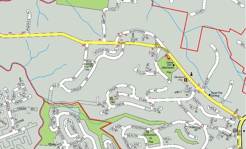
Street map showing the Rural Fire Service
Download original ↗789 × 478 pixels
Read alongside the image
Description & visible labels
A description of the visible layout and labels; not a complete text transcription.
DESCRIPTION OF MAP AND LEGIBLE LABELS — not a complete transcription of every street and lot number.
A colour street-directory extract centred on Glenhaven Road. The Rural Fire Service is labelled beside Glenhaven Road near Evans Road and Kyle Avenue. Other labels include Glenhaven Primary school, “Cnrty Clb Glenhaven” [abbreviation as printed], Glenhaven Oval and a church symbol.
Visible road and place labels include Glenhaven Road, Old Glenhaven Road, Holland Road, Edgecliff Road, Warren Place, Woodburn Place, Temora Road, Sylvan Grove, Gilbert Crescent, Cattai Ridge Road, Mills Road, Cattai [partly cropped], Mardi Court, Yiena Way, Smyly Road, Broadoak Place, Linksley Avenue, Grange Road, Fingal Avenue, Davis Place, Caig [uncertain], Adah Place, Ashley [partly legible], Hyde Avenue, Evans Road, Greenbank Drive, Gresham Place, Cleadon Place, Ridgecrop Drive, Ferncliffe Road, Beacon Avenue, Farm Place, Kyle Avenue, Fullers Road, Carinda Road, Manns Avenue, Avens Avenue, Brittany Place, Crego Place and Drawbridge Place.
Red lines divide areas; blue lines mark watercourses; green shading marks open space. Some edge labels are cut off and small labels are [illegible].