Outer Sydney Orbital

Protecting the Cumberland Plain woodlands
Update: 9th October 2020. I have made a submission to the State Government on the Conservation Plan. Read it here.
This week the State Government placed the Draft Cumberland Plain Conservation Plan on exhibition for comment.
This is a significant document for a number of reasons, although it has some failings which my submission to the Minister will seek to remedy.
The Cumberland Plain is a generic term for the (mostly) flat geographical area laying between eastern Sydney and the Blue Mountains, encompassing Western Sydney from the south near Wilton to the north including the Hawkesbury-Nepean floodplain. The forests and grasslands it used to host have been significantly fragmented by urban development, and previous attempts to create woodland corridors or "green lungs" for Sydney have been eroded over the decades, which I've written about before, and explained in a video.
The first thing to observe is updated maps relating to the location and extent of the M9/OSO road and infrastructure corridor are a part of the plan, and now formally exclude areas north of Richmond Road. This is heartening, but our community will not have certainty until the final extents are gazetted, which is in my opinion, signficantly overdue.

While we're on the subject of corridors, the Draft EIS offered alongside the RMS proposal for the M9 included maps which purported to show the extent of Cumberland Plain Vegetation (of various types) along its path.
However, these maps were greatly at variance with other maps, such as NPWS maps, which showed significantly greater coverage.
I pointed this out at the time, both in an article and a video showing exactly how the extent of Cumberland woodland has been underestimated. I also created a Google Earth Overlay comparing the two.

The green areas above represent “Threatened ecological communities” and the hatched areas represent “Cumberland Plain Priority Conservation Lands”.

Looking through the 3256 page Draft Assessment Report in the new plan that has been released, it would appear that few actions to update vegetation coverage maps have occurred in the Hawkesbury, in favour of study areas closer to the Aerotropolis closer to Badgerys Creek. I would have preferred that a Conservation Plan incorporating the Hawkesbury took at least some time to update the relevant studies to snapshot the state of the Cumberland vegetation in the Hawkesbury. Instead, the focus is overwhelmingly on the southern areas subject to more intensive development.

One representative example of this is the treatment of an iconic species prominent to the Hawkesbury, such as the Downy Wattle (Acacia Pubescens).
A 2003 NPWS study showed 116 known populations of the species, with just over half of those known populations containing fewer than 20 stems. There are sites in Windsor Downs, Mountain Lagoon, Pitt Town and Scheyville are the major sites in the Hawkesbury LGA, and yet the draft Assessment Report instead targeted study areas on Penrith, Badgerys Creek and Wilton.
Considering the State Government’s use of maps in their planning that are seriously out of date, or which disagree with other data, I hoped the Government would take the opportunity to do new work to establish current coverage and biodiversity threats to what’s left – especially in those areas of the Hawkesbury that will be likely subject to the greatest development pressure within the time horizon of the plan (out to 2056), like Vineyard, Oakville and Maraylya.
Submissions have been extended to 9th October 2020. I encourage you to make your views known.

The BLOR and M9/OSO Corridors, Part 2
This post is the second of two in response to a proposal to create two motorway and rail corridors through the Hawkesbury.
The first video provides some historical context to the broader phenomenon of State and Federal governments foisting large projects on unsuspecting communities. The challenge of balancing long term planning and the impact on individual communities has frequently been botched, and I cited the history of corridor sell-offs, and earlier proposals for airports, prisons, dumps and new suburbs, by both major political parties, as salutary examples.
What follows is a transcript of the video, with documents referenced on-screen linked or inserted as needed.
TRANSCRIPT:
In the first video, I provided a small history lesson about the litany of misguided schemes that governments of both hues have cooked up over the decades for the Hawkesbury, and how each one, after a fight from the community, was scuttled, and the government of the day had their asses handed to them, on a plate.
Today, let me be far more specific about the current corridor proposals. This video is also a part of my submission to Transport for NSW.
Point 1: Both these corridor proposals are equally bad.
It is true that the Bells line of road corridor has gained more publicity here in the Hawkesbury, including through a very well attended meeting at Clarendon showground a few weeks ago. But the fundamental problem of both corridors are the same.
Both corridors divide rural communities, destroy productive agricultural and equine lands, diminish visual amenity, endanger ecological communities and threaten the futures that families thought they had by buying homes outside of what I call ant-nest Sydney.
And both corridors suffer from the deficiencies of process that have landed these proposals on unsuspecting voters, without sufficient community consultation, without enough knowledge of the options to make meaningful contributions to the debate, and in a time-frame that is far too short.
The community has had barely 8 weeks to inform themselves and organise to have their say on projects that may happen decades from now. What’s the rush?
Point 2: The River crossing has to be back on the table

We are free to speculate that the government will change its mind about the Castlereagh corridor. It may default to the original 1951 alignment, and it may choose to stop at the Hawkesbury Nepean river instead of crossing over it.
If that’s the case, then the question of an extra crossing of the river must be back on the table.
I always believed that only someone as major as the M9 could deliver what we’ve always needed – a new crossing of the Hawkesbury Nepean River, somewhere between North Richmond and Wilberforce.
It turns out that we got proposals for two corridors, and neither delivered. The briefing Council received on the Castlereagh corridor actually suggested that it would help alleviate traffic on Windsor Road, by putting a new crossing of the river at Castlereagh, more than half the way to Penrith. Bollocks!
But what a huge political win it would be for the party that redirected the M9 along, say, the south creek floodplain, crossed the Hawkesbury river downstream of Windsor bridge, and joined it to the Putty road, providing a link to both the Hunter and Newcastle as originally intended.

Point 3: Why are both corridors roads to nowhere?
The Bells line corridor is irrelevant unless there is a major amplification of Bells line itself west of Kurrajong Heights and over the range. There isn’t anything like a compelling case for this given that billions have been spent over the last two decades to upgrade the Great Western Freeway.

And the M9 corridor konks out at Maraylya. Here’s what the terrain looks like between there and Newcastle. Mountainous terrain, National parks, wetlands, another major crossing of the Hawkesbury River, and well downstream, so the river is broader and deeper.

If there’s little prospect of the corridor being driven north of Windsor Road, why endure the political pain of taking it even that far?
Point 4: Why is the government’s material contradictory and incomplete?
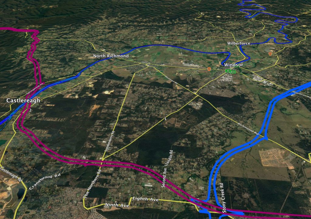
Why do the government’s press releases and maps state that the corridor passes through Box Hill?

Below, the area in purple is Box Hill, in the Hills Shire, and on the left is the corridor. They are not the same.

Why does the draft EIS reference the M9 corridor as only running from Windsor Road and south to the Hume Highway at Menangle?

Why is the vegetation study in the draft EIS so incomplete?
I’ve created a tool in the program Google Earth. The online map that Transport for NSW provides is difficult to navigate and doesn’t allow you to leverage other geographical datasets and overlay them on the corridor.
This overlay I’ve created allows you to see the Hawkesbury ends of both corridors and toggle them along with other useful data, like alternative routes and a vegetation study.
There’s a link to this overlay at my website, along with a longer video tour of what it shows. All you need is the Desktop version of Google Earth for Mac or Windows, and that’s a free program.
Nobody else seemed to be doing this kind of analysis, so I thought I’d do my bit.
What you can see here is the area of the M9 north of Windsor Road, in Oakville, Vineyard and Maraylya. Here is an overlay of the vegetation study map that appears on page 96 of the OSO Draft EIS dated March 2018.

This looks a little muddy, but the green areas represent “Threatened ecological communities” and the hatched areas represent “Cumberland Plain Priority Conservation Lands”. Even from this map, it’s obvious that the M9 corridor goes through threatened ecological communities.However, what concerns me more is that this map is incomplete.

Here is a 2002 map from NSW National Parks overlayed on the same area. It shows many more stands of Cumberland Shale Forest – areas that just don’t appear on the Transport for NSW Map. And it’s not because there has been mass deforestation since 2002 – the amount of tree cover in this area has remained pretty constant over the years, precisely because landowners look after them as rural lands.
If I toggle the layers, you can see a huge difference. The draft EIS has massively underestimated the tree cover, and the conservation value of the lands under the M9, and it seems apparent that the BLOR corridor study suffers from the same defect.
Point 5: What is the future of this part of the Hawkesbury anyway?
The government can’t have it both ways. It says it needs to reserve this corridor through the area because of future land use pressures. But this land is currently zoned rural, for acreage properties.
Here’s the property on the corner of Old Pitt Town Road and Speets road – part of the Sydney basin’s diminishing store of productive agricultural land. It’s also smack bang underneath the M9 corridor.
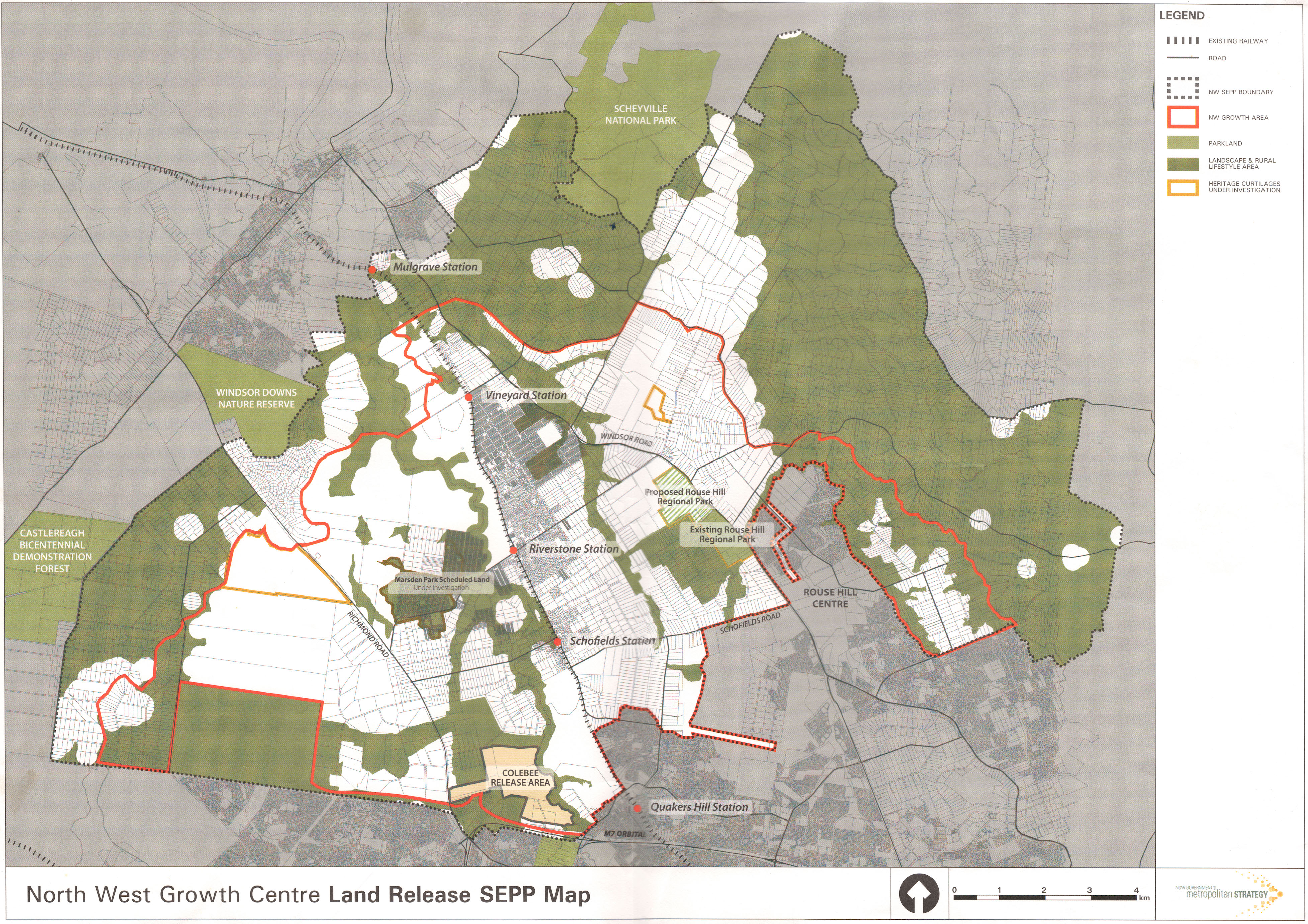
Here’s a map you’ve probably never seen. The red area is the area defined by the current North West growth sector. The part that’s in the Hawkesbury is this bit south of Commercial Road and Menin Road.
The outer dashed line represents the outer boundary of what’s called the SEPP – it’s the planning instrument that makes the North West Growth sector possible. It encompasses a much larger area – all of Oakville, the rest of Vineyard, most of Maraylya, and parts of Mulgrave and McGraths Hill.
Why stick a fuse in something unless you’re going to light it? We already know large chunks of land inside the dashed boundary, but outside the North West Growth Sector, are already subject to development, like this huge area north of Old Pitt Town Road. When will the other shoe drop?
Hawkesbury Council will be reviewing its Residential Lands Strategy later this year. I grew up in Oakville, and live there still. My heart is to protect our rural amenity and provide a buffer between the development at our door, and our agricultural lands, the National Park, and the remnant Cumberland Woodland that still exists outside the boundaries of the park.
But as an elected representative, I have to weigh what is best for the whole community. If there has to be development in the Hawkesbury, this is the area closest to Windsor Road, closest to the new rail infrastructure, not subject to the pinchpoints of the river and its inadequate crossings, and relatively flood free.
I’m calling on the state government to be honest with the community and to tell us if there are any plans to subdivide land outside the current growth sector boundaries.
For example, there's this from the OSO Draft Strategic Environmental Assessment, which says:
The Growth Area LUIIPs have assumed that the recommended corridor will be formally identified in the future, and will inform more detailed planning for precincts yet to be rezoned. For example, the DPE is considering land immediately north of the Vineyard Precinct as providing future opportunities for employment and industry related to the future OSO infrastructure, with detailed planning to commence once the location of the recommended corridor is formalised.
The areas north of the Vineyard Precinct are in Oakville and Maraylya, and are currently zoned "Rural". Questions I have asked of departmental officials about the long term future of Oakville, Vineyard and Maraylya have been met with silence.

Point 6: Why weren’t we told?
Minister for Western Sydney, Stuart Ayres made much of saying that the announcement of these corridors was already the culmination of plenty of consultation with the community. Bollocks.
Here’s a glossy document that came out in 2014, three years ago, titled “A plan for growing Sydney”. And in that document is the only map I’ve ever seen that shows, before this announcement in March, where the corridors may have been.

It clearly shows the possibility for these corridors to affect Castlereagh, Grose Vale, Yarramundi, Bowen Mountain, Kurrajong in the west; and Oakville, Maraylya and Vineyard in the East.
No one I have spoken to in any of those communities were consulted. Not one. And not Hawkesbury Council, to the best of my knowledge.
Point 7: There are plenty of alternatives.
I’m not a town or transport planner. Maybe you are. But why has the government placed one option for each corridor before us, and left it to us to suggest alternatives?
I feel inadequate to the task, but here are some starters.
Stop the corridor at Windsor Road.

Follow the South Creek catchment and cross the river downstream from Windsor (see map above)
Follow the alignment of the North West Rail Line extension corridor.

Or, there's this proposed solution from a road lobby group, Roads Australia.

Lastly, the funds could be diverted into local road solutions.
Point 8, and my last: Do not forget the political dimension.
I am an elected Liberal, and statistically, most Hawkesbury voters are Liberal voters. This isn’t a left-right thing – my last video showed you a long list of awful thought bubbles foisted on us by past governments of both hues.
But I lament that the bad way in which this issue has been handled by an otherwise praiseworthy state government has given a huge free kick to our political opponents.
The government has made a mistake in both these corridors. I can’t find it in my heart to attribute to malice what can easily be explained through stupidity.
The government simply needs to step back, realise it may well lose the next State election if it keeps this up, and without ego, change its mind – just as it was mature enough to do on the question of council amalgamations, greyhound racing, and stadiums.
I think it’s actually the mark of a good government to put things out there and then really heed criticism. It needs to do that now, because the damage has already been done.
Even if you’re watching this after the deadline for community submissions, which is June 1st, please let me encourage you to keep the pressure up, especially by calling and writing to the office of your state member of parliament, Dominic Perrottet, Stuart Ayres, and the Premier, Gladys Berejiklian.
My name is Nathan Zamprogno, and these views are my own. They are not Council policy and they are not the “Liberal Party line”, whatever that is. I’d love to know what you think.

A Google Earth overlay of the OSO-M9 and BLOR-Castlereagh corridors
In my videos on the OSO-M9 and BLOR-Castlereagh corridors (Part 1 and Part 2 are here) I reference a Google Earth overlay I developed that draws together data from a variety of sources.
My other posts do not tour the various layers that have been incorporated into the layout, so I made another short video to show you around.

Please note that my focus is on the northern extents of the corridors passing through the Hawkesbury LGA. My apologies if you have come here from the Camden locality looking for data on the southern extent of the M9. Perhaps someone down your way can do a similar analysis.
What is a Google Earth overlay?
You are already familiar with Google Maps. Perhaps you use the web based version on your browser or smartphone.
There is a more powerful standalone app called "Google Earth", which allows more sophisticated data to be layered on top of the general map, and layers can be toggled and edited.
The document format for an overlay carries the ".KML" or ".KMZ" extension. They are functionally the same. ".KMZ" files are simply compressed and take up less space.

How do I get Google Earth?
It's free! There are versions for Windows and Mac, and you can download them here.
There is also a version called "Google Earth Pro", and it will work, but the standard version is fine.
Can I use the version of Google Earth through the Google Chrome Browser?
Not to view my overlays. You need to use the app for Mac or Windows. You can't use the Google Earth App for Android or iOS, either.
Where can I get your overlay of the road corridors?
At THIS LINK HERE.
What do I do once I've got it?
If you have Google Earth installed, and you've got my file "M9_BLOR_Corridor_Analysis_Clr_Zamprogno.kmz"
then double-clicking it should bring it up in the Google Earth program as a series of layers and folder in the left-hand pane of the app. Experiment with toggling them on and off. You can do this individually or as whole folders.
Note that the layouts will come up with a splashscreen with my notes. It's the first thing you'll turn off by deselecting "Title Graphic" in the left hand pane.

The BLOR and M9/OSO Corridors, Part 1
This video is the first of two, and explores the history of government attempts to ride rough shod over the community, and what has tended to happen when they try.
It is intended to encourage people engaged in the current struggle to protect the Hawkesbury from two destructive corridor proposals to recognise that these kinds of things have come along before, and the community has generally won.
The second video will be more specifically focused on the reasons why the current proposal is a bad idea.
Transcript:
In this video, the first of a two-parter, a history lesson about why the government's proposal to drive motorways through the beautiful vistas of the Hawkesbury is deja-vu, all over again.
I’m Nathan Zamprogno, one of your elected Liberal Councillors on Hawkesbury City Council.
Barely two months ago, the State Government announced a consultation period in relation to two proposed road and rail corridors passing through the Hawkesbury district.
The Castlereagh Corridor proposes a crossing of the Hawkesbury-Nepean River at Castlereagh, and then goes through Yarrramundi, Grose Vale, Bowen Mountain, Kurrajong, and rising steeply to join Bells Line of Road at Kurrajong Heights.
The Outer Sydney Orbital or M9 corridor runs north from Camden, passes through the site for the new airport at Badgery’s creek, strikes north-east from Marsden Park and would decimate communities in Vineyard, Oakville and Maraylya.
At some indeterminate point in the future, it is suggested that it will go all the way to Newcastle. Pigs might also fly.
As an elected Liberal, I’m stating my opposition to both corridors.
Even though the State Government is of my party, a dumb idea remains a dumb idea wherever it comes from.
Recently, all four of your local Hawkesbury Liberal Councillors voted unanimously with all the other Councillors to express our concern about these corridors, and to seek a better solution, in a motion passed at Council on May 8th.
I want to explain why, and the best way is a video two-parter.
Both videos are a part of my own submission to Transport for NSW.
You may have cause to agree and disagree with me simultaneously – and that’s because I’m doing my job. I’m aware that I need to represent a range of views. But stick with me.
This video, part 1, is called “We’ve all been here before”
After this, watch part two, called “Surely, we can do better than this?”.
Since everyone loves lists, let’s roll with that.
Point 1: There’s nothing wrong with the idea of corridor reservation.
I promise this is the only overtly political thing I’ll say – so I’ll get it over with.
Look, we criticise governments for failing to engage in long term planning, and we’re especially critical over the issue of transport congestion.
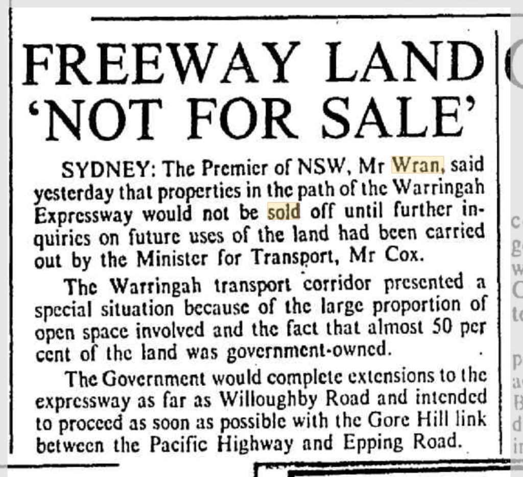
Those of us with an eye to history remember that it was the Wran Labor government who left a ruinous legacy of flogging off road corridors for the M4 and elsewhere in 1977.

Now, taxpayers are left with multi-billion dollar bills for projects like Westconnex, or the north-west rail link – made ridiculously more expensive precisely for the lack of some bold, long term planning decades ago.
But lest you think that I am mounting a defence of wall to wall freeways – think again. Sydney needs a coherent mix of road and public transport networks.
We need to avoid “Los Angeles-isation” of our city. But if this infrastructure barely keeps pace with an eternally growing population, it merely creates the illusion of progress while we actually go backwards in terms of our quality of life, sustainability outcomes, and commute times.
It alarms me that none of our leaders are prepared to ask the question “When will Sydney be full”? It’s a simple enough question, and shouldn’t be heresy.
I’ve used Dick Smith’s compelling documentary “The Population Puzzle” with my students.
It alarms me that Sydney is growing without any leadership on the question of what it’s maximum population should be.
I believe that Australia’s sustainable future lays with both limiting population growth, and providing sharper incentives for decentralisation – sending demand outside of our capital cities. we need to have a period of consolidation in Sydney, so that our infrastructure can finally catch up. People are very angry about this, and it may prove decisive at the next State election.
however, that's a huge topic which I’ll say more about in another video.
Point 2: We’ve all been here before
Confession: If this begins to sound like a history lesson, it’s because I am a qualified history teacher. But indulge me; because it’s really important to understand some historical context, so we can understand why this kind of thing keeps coming up.
I only need to pick one small part of the Hawkesbury to illustrate in microcosm what happens when governments suffer from these repeated thought bubbles and then ride rough-shod over the community.

Back in 1948, there was a master blueprint for Sydney called the “County of Cumberland” plan. It understood that a healthy city contained a dense core, a ring of urbanised suburbs, and most importantly, green belts that served the city with recreational spaces, productive agricultural land, wildlife preservation and visual amenity.
It was a great idea. And it didn’t last. Sydney wide, the pressure for growth at any cost gradually eroded the green belt idea.
All the land in our neck of the world was farms and rural properties. And the land now next to the proposed M9 corridor, is Scheyville National Park. It was gazetted in 1996. But before it was a National Park, it was one of the largest contiguous parcels of crown land left in the Sydney basin. Which is why, by turns, various governments, Labor and Liberal, state and federal, if I might paraphrase HG Wells, “looked upon us with envious eyes, and slowly, they drew their plans against us”
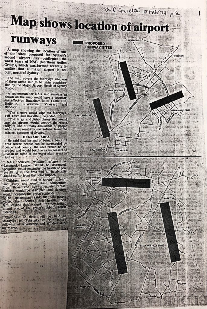
In 1978, there was a serious proposal to make Scheyville and Pitt Town the site of Sydney’s second airport.

This bubbled away for years. One of my earliest memories, and a kind of political birth for me, was seeing this map of the proposed locations of the runways.
My home at Oakville was underneath one of them. The irony that these airport runways now also lay directly beneath the path of the M9 shouldn’t escape us.
The proposal created uncertainty and dread just like we’re seeing today.
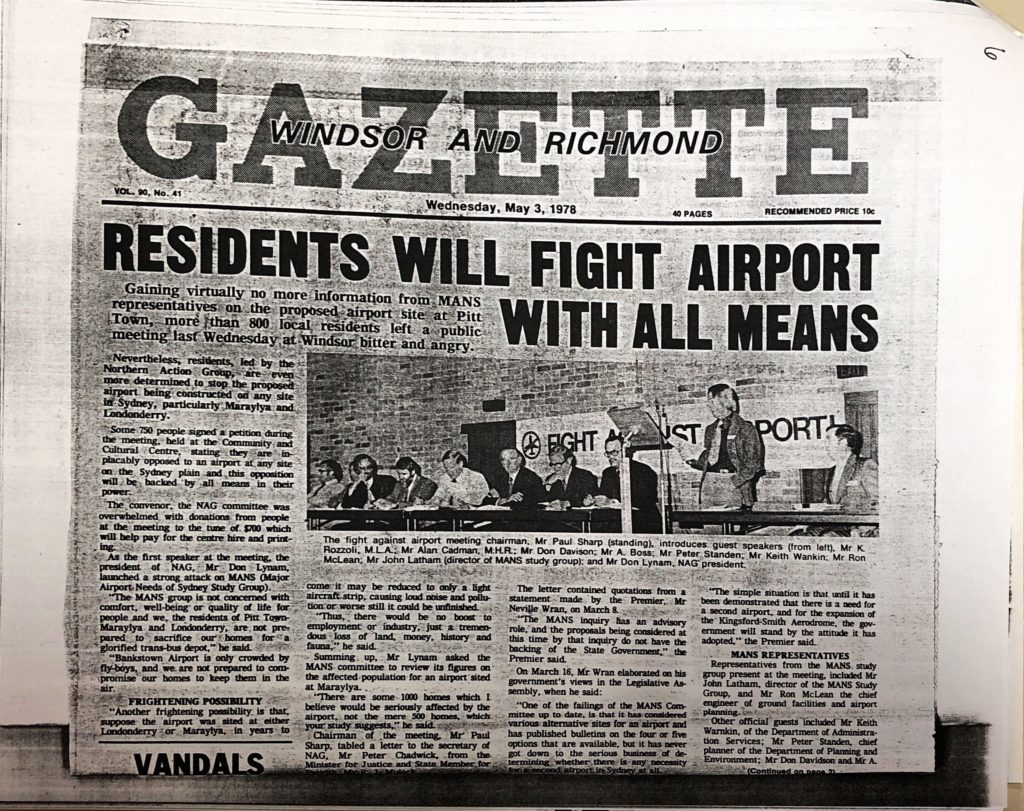
I think it’s significant that, by 1983, the State, Liberal member for Hawkesbury, Kevin Rozzolli, was prepared to speak out strongly on behalf of his constituency. He said:
“Mainland Australians are concerned at the environmental damage that may occur should the Franklin Dam be constructed in Tasmania.
The same people should be concerned about consideration of the siting of an International Airport in the area… variously described as Nelson, Box Hill, Rouse Hill, Maraylya, Oakville and Pitt Town”
“The major factor is not technical feasibility… but whether such construction will so alter the character of the area in which it is located that it will destroy forever a part of Australia’s heritage, a heritage at least as priceless as the Tasmanian wilderness”

I'll underline that: Our State Liberal member was prepared to liken the natural and historical heritage of Oakville, Maraylya and Pitt Town as analogous to that of the Franklin river in Tasmania. He went on:
“The natural endowments of the area which have created the unique circumstances of its history, scenic beauty and quality of life, demand its preservation as part of Australia’s heritage”.
That heritage is still relevant today.
Dominic? I am calling for you to show the same conviction that your predecessors have.
Let’s move on. In 1987, the same site was announced for a massive, maximum security prison, bigger than Parramatta gaol.
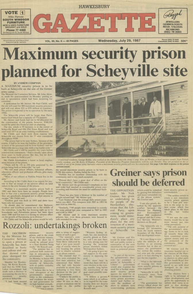
Again, the local Liberal state member for Hawkesbury was in the vanguard in condemning the idea, saying
“I am going to give my full support to the community in opposing this gaol”
In 1991, the Government announced that Scheyville was at the top of a list of preferred sites for a what would have been the largest rubbish dump in the southern hemisphere.
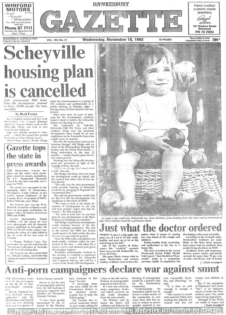
In 1992, the government announced that the same area would be the site for a massive housing development. Hawkesbury Council issued a prospectus that showed bushland at Oakville and Scheyville bulldozed and replaced with a new suburb of 20,000 people, complete with four new primary and high schools, and urban runoff draining straight into Longneck creek.
So, my point? We’ve all been here before. There's nothing new under the sun.
But also: People power can win!
Each of these proposals, presented in most cases as necessary and inevitable, were knocked on the head by the community rallying to make the government see sense.
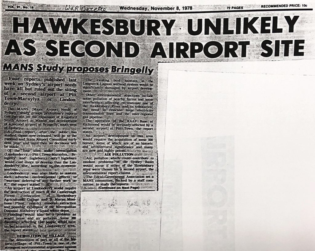
The airport idea was scuttled.
The dump didn’t happen. The prison idea went the same way

And the plans for a massive new suburb? Stopped cold.
And eventually – we got the land around Scheyville gazetted as a new national park. I was 22. It was the year after I first stood for Council. I played a small role in that fight, and I’m kinda proud of it.
You’ll note that I’m not political point scoring here: These rotten ideas were proposed by both Labor and Liberal governments alike.
What matters is people standing up and demanding that their leaders listen to them.
The point of this history lesson is this: People can make a difference, and governments can be made either to see the light or feel the heat.
In the second video, I’ll be listing the reasons why this particular proposal isn’t good enough, and suggesting some alternatives. I hope you'll join me.

Hawkesbury City Councillor Zamprogno interviewed on Hawkesbury Radio on corridor reservations
I was pleased to be invited by Gary Cotter from Hawkesbury Radio today and talk to him about the State Government's announcements of land reservations for both the Castlereagh corridor (Bells Line of Road) and the Outer Sydney Orbital (M9) corridor.
Both these announcements may have substantial impacts on the Hawkesbury. On the one hand, governments should be praised for forward, generational thinking. On the other hand, their claim that the chosen locations were based on extensive community consultation is completely false.
Listen along to the interview (<14min) and tell me what you think. There will be much more to say about this soon!
https://soundcloud.com/nathan-zamprogno/nathans-hawkesbury-radio-interview