Sydney Development

Should we lower Warragamba Dam instead of raising it?
Last week Council met for the first time since the July floods. The Mayor advanced a motion that calls on the State Government to change legislation regulating the operation of Warragamba Dam to permit the Dam to be lowered in times of likely high-rainfall which will provide a degree of flood mitigation ability.
I supported the motion, but I want to be very clear that lowering the operating level of the dam is not a substitute for raising the dam wall, which remains the best way to properly mitigate floods. Lowering the dam level might have taken 20-60cm off the level of the flood. Raising the dam would have taken off 3.5 metres, based on the smaller March 2021 flood.
As I say here, climate change will deal us times of greater variability of weather in coming years. Longer periods of flood and longer periods of drought. The reductions being sought by some at our meeting last Tuesday would have let the whole dam run dry prior to the end of the last drought in February 2020. That's just as irresponsible. I see a lot of people advancing positions in the teeth of scientific evidence they're wrong, and that's no way for us to get to the best solution.
Whether to raise or lower the Dam was also the subject of an excellent story this week on Channel 9's A Current Affair.

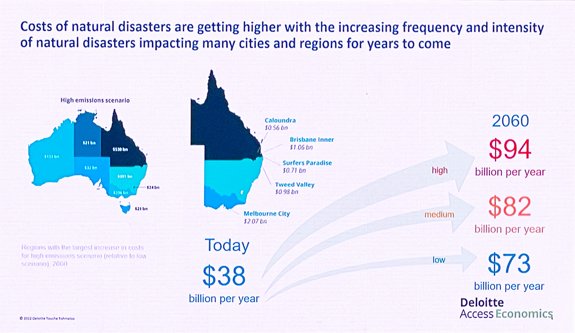
The Hawkesbury-Nepean flood of July 2022 – the worst since 1978
July 5th 2022 represented the worst day of flooding in the Hawkesbury in 44 years.
This flood exceeded 13.93m, beating both the March flood (13.71m) and the 2021 flood (12.91m). You would have to go back to 1978 (14.5m) to see a worse flood. The 1867 flood was 19.6m. A "one in a hundred" flood is 17.3m, each measured at the Windsor gauge.
I toured the district, commiserated with locals, and took note of what I saw. This video represents the waters as they peaked. Councillors are being briefed daily by Council staff and we're proactive in guiding the response to the emergency.
I am reminded yet again how magnificently we stand by one another in times of trial. Our community is strong, and the only way we can get through this, is together.
There is one common misunderstanding that's worth clearing up, because I hear it very frequently.
Warragamba is not a flood mitigation dam. It was built as a water storage dam in 1960 and legally cannot be deliberately operated at below 100% capacity in the sense of dumping water overboard in anticipation of a rain event, or permanently operating it at a lower capacity. This is unlike other city dams like the Wivenhoe Dam in Brisbane which has a permanent 'air gaps' to act as a buffer in times of flood. Wivenhoe's water storage capacity is 1160 gigalitres but its air gap is a further 1967 gigalitres. IN other words, two thirds of its capacity is a flood buffer.
Warragamba's current capacity is 2031 gigalitres, and the plan to raise it by 14m will add about 1000 gigalitres of emergency storage.
Some have argued that the water level could be drawn down from 100% as the result of a long range forecast for rain, anticipating an East Coast Low for example. Others argue the permanent level of the dam should be lowered and that this is equivalent to the kind of mitigation that raising the dam would confer.
However, this would not confer a sufficient degree of mitigation to be worthwhile. And here's the analysis of flood hydrology that proves it:

If the dam level had been drawn down just before the 2021 flood, the resulting flood height would have been only 20cm lower.
If the dam was permanently kept lower by as much as 5m, it would have made a 60cm difference. Any more and Sydney's drinking water would be imperilled. Had the water supply been lowered by 5 metres in 2016 for example, the dam storage would have dropped to around 26% in February 2020 at the end of that drought – a critically low level, even lower than during the Millennium drought when the storage reached 32%.
If a raised dam had already been in place, 500 of the 600 houses flooded along the Hawkesbury-Nepean floodplain would have been spared since that flood would have been 3.5m lower. And in the events of still-larger floods, the degree of protection grows further.
Only raising Warragamba dam will confer the necessary degree of mitigation. I commend this Infrastructure NSW FAQ and also the NSW Government's post 2021 flood report for more information.

Sky News Australia special report into flooding on the Hawkesbury-Nepean River

However, raising Warragamba Dam is a necessary part of a larger strategy. In the Flood Emergency Plan our Council adopted in 2020, the maintenance of effective evacuation routes was listed as a critical priority.

The Hawkesbury-Nepean River Floods - March 2022
July 2022 update. It's flooding again. Again.
I have been talking about flooding on the Hawkesbury-Nepean river for many many years. If you've arrived at this page as the result of a Google search, please consider these resources:
• My more recent video and post about the July 2022 floods, with some very striking video
• All my output on this website about flooding.
• My YouTube channel. This link should prioritise my videos about flooding. Please subscribe.
Original March 2022 post:
Flooding has again struck our community for the second time in 12 months.
This flood has risen to 13.7m (as measured at Windsor - which tends to be the benchmark), beating last year's flood of 12.9m making it approximately a 1-in-20 year event.
This video was taken when the waters still had about 2 more meters to rise.
I'm indebted to the excellent Hawkesbury Flood Statistics facebook page for making excellent real-time data available about river heights and closures.
Here's their summary after the waters subsided:


On ABC Breakfast Radio about Warragamba Dam (again)


Hawkesbury Council rejects critical flood safety measure – Again!
Our community has known we have to 'Live with the River' since the time of settlement. Our relationship with the river and the inevitability of floods mean we're forever torn between the blessings of rich soils and the river's deadlier moods. My own ancestor was killed in Windsor in the flood of 1809.
But human ingenuity has given us the ability to dam rivers, and we're now told that raising Warragamba Dam by 14 meters will reduce the frequency and severity of flooding here by 75%. That it would reduce the number of homes flooded by 5000. That the damage bill would reduce by $3,000,000,000. We need that. If only we had it in March – it would have spared 500 homes and reduced the flood height by 3.5m.
The new EIS is open for public comment until the end of November. Here are all the EIS documents, and I strongly suggest you start with the Executive Summary, given that the whole EIS is 8092 pages long. Council would be completely negligent on behalf of our community, who endure the highest risk of flooding in Australia, if we didn't make a submission. Submissions run until the end of November. You should consider making a submission (look for the link in the top right corner)
I'm appalled that a majority of Councillors are so wedded to their ideology that, at last night's meeting, they voted even that down. The video above summarises what happened at the meeting.
That's right - they voted down even putting forward our own community's concerns in a document to the State Government.
I know not everyone agrees on this issue, but this is reckless and treats the 600 families whose homes were flooded out in March with contempt.
And yes, this absolutely should be an election issue.
I have of course been very, very active on the subject of flooding over this five-year term of Council: Here's a list of all my videos and motions before Council on this subject.

Make no mistake - raising Warragamba Dam will make our community safer


Raising awareness of the need for Hawkesbury-Nepean River Health

The purpose of the visit was to raise awareness of river health, a responsibility I share as the Chairman of the Hawkesbury River County Council, which covers four Council areas and much of the river from Warragamba to Wiseman's Ferry.
We have specialised plant and equipment at HRCC which is essential to keep the river free of weeds, and were disappointed when the State Government pulled some key operational funding last year - just as we completed the salvage, refurbishment and recommissioning of our giant 'Weedosaurus' harvester with a $130,000 Federal grant.
My belief is that taxpayers, to say nothing of key river user groups like Rowing Australia, representing our Olympic team training on the river for the Tokyo games, expect the tiers of government to work together co-operatively to undertake this critical and ongoing work.
Minister Evans was a thoughtful listener and we gave him a detailed account of the effects of the floods earlier this year, the temporary reprieve it has given us as it flushed the river, and the short-sightedness of forcing us to sell our plant and equipment when weeds, like grass, will inevitably grow back. This is a warning I have delivered before.
The above story appears in this week's Western Weekender, and follows earlier coverage back in February.


The Hawkesbury Floods, March 2021
Some times it must feel like our community can't cop a trick. Devastating fires, pandemic and two floods, all within a 16 month period.
Yet again, out of the distress and destruction of property has arisen the real spirit of our local community, which has rallied magnificently. The response of our SES, Police and RFS have been truly heroic, and they deserve our respect, as do those who just help because it's the right thing to do. Neighbours help neighbours. It's the Hawkesbury way.
I tried to document the effects of and responses to flooding by visiting as many places and people as I could. These videos have apparently reached over 111,000 people on social media.
Since the waters have receded, I've been honoured to be present variously at the visits of the Governor General David Hurley, The Premier Gladys Berejiklian, Deputy Premier John Barilaro and Minister for Roads Andrew Constance.
It has also brought the need to raise Warragamba Dam back into focus.
The plan to raise the dam is about the safety of the community – the 134,000 people who live and trade on the Hawkesbury-Nepean floodplain. It isn't about development, or Sydney's drinking water supply. Nor should the debate be unduly focused on the temporary inundation of uninhabited bushland around lake Burragorang, for a week or two, once or twice a century.
The Resilient Valley, Resilient Community flood risk study released in 2017 explains 75% of our flood risk comes from the Warragamba catchment. It also points out that raising the dam would reduce the severity or frequency of bad floods by the same proportion – 75%.
Floods have already been averted or reduced by Warragamba, under certain circumstances. Severe rain events that began at the time of the early 1990s flood, when the dam was depleted to about 46% capacity, lowered the subsequent level of waters of on the floodplain by over three meters. This is the kind of 'accidental' mitigation that needs to be built into the dam permanently.
It really disappoints me that some of the commentary from people opposed to the project is so dishonest. This recent article in the Blue Mountains Gazette, and the comments of ex-Minister Bob Debus should anger everyone at risk of flooding, especially because he, like other opponents of the dam raising are usually high and dry and out of harms way. Our community in the Hawkesbury bears the brunt of this risk. I've pointed this out on many occasions.
Over the last fortnight I have stood with many people who have lost their homes and possessions because of Mr Debus' inaction in the 1990s, when there was a plan to raise the dam by 23m. The Labor government's decision not to treat this as a bipartisan issue and scotch those plans, which were shovel ready when Bob Carr was elected in 1995, is partly responsible for the damage this flood has caused.

Mr Debus says raising the dam won't prevent all floods. But wearing a seatbelt won't prevent all car accident fatalities. Backburning won't save every house in a bushfire. But only an idiot would argue against doing what we can.
Imagine if the present floods had been 3 meters lower as a result of being able to hold back 1000 gigalitres of that water for long enough to allow them to drain away.
When Mr Debus only notes the quarter of floods that result from rain in other tributaries, he's misleading you. And he's wrong to state that permanently lowering the dam levels by 10m is the same as raising them by 10m, because of the tapered shape of the dam. The bottom 2cm of a wine glass holds much less than the top 2cm.
And pre-emptively reducing water levels in the dam, which every armchair expert has advocated over the last fortnight would (literally) be a drop in the ocean.
The topical unit is the 'SydHarb' - A Sydney Harbour's worth of water, or about 500 gigalitres. Warragamba can hold 4 Sydharbs, and the dam raising project will add another 2. I was talking about this a decade ago. Lowering the dam to levels that would imperil Sydney's drinking water supply to create a buffer would have taken weeks, and would account for maybe 0.2-0.5 Sydharbs.
In comparison, the inflow of water resulted in a Sydharb *per day* topping the dam for 2-3 days. If we could have absorbed two days of that inflow and let it out over a week or fortnight, many of the grieving people who have lost their homes, goods or livelihoods would have been spared.
Lastly, Bob raises the debunked-a-thousand-times canard of development on the floodplain. The 1:100 flood height buildong controls will not change. Not a single square meter of land which is presently sterilised by these controls would be opened up for building in the event of raising Warragamba. And the only time any flood has exceeded the 1:100 level in the last 222 years was in 1867, showing this is a reasonable safety measure. The sad fact is that the 5,500 houses built below the 1:100 level were built before those flood height controls were implemented.
Damn you, Bob Debus, for your reckless conduct as a Minister - when you actually had a chance to do something about this, you sat on your hands.
I spoke to the media on several occasions to represent our at-risk community
Print stories: Central News (18-11-2020), ABC (27-3-2021), AAP (23-3-2021), and TV as below:
It concerns me that in each of these cases, the voice of the community at most risk is not emphasised in balancing the costs and benefits of flood mitigation.
An excellent book I have at home on the history of the construction of Warragamba Dam in the 1950s is subtitled "Thank God there were no greenies." I worry that an inability to soberly judge the necessity of flood mitigation will eventually cost lives, when a flood bigger than this one finally comes.
Nature has given us a warning. Are we wise enough to heed it?
Hawkesbury Radio interview, February 2021
This week I had the pleasure of sitting down with Garry Cotter at Hawkesbury Radio 899 to talk about my personal opinions on a wide range of issues.
The fate of a concrete recycling plant continues to be of concern to residents of Ebenezer, and I had an update concerning an upcoming planning panel meeting, along with remarks about the deficiencies of Planning Panels generally.
As a member of Council's Civics committee, I congratulated our Australia Day award winners.I put on my hat as the Chairman of the Hawkesbury River County Council and raised a concern that key aquatic weed control activities are at threat because of a bad funding decision by the NSW Government.
I spoke about some very recent changes to a proposed 580 lot subdivision at the Jacaranda site (off Kurmond Road at Glossodia).
Finally, I spoke about the ongoing pressure for development in the Oakville, Vineyard and Maraylya areas, and efforts I've made to consult with that community.
Timecodes:
0:00 Concrete Recycling Plant, Ebenezer, and Planning Panels
8:06 Australia Day award winners
10:01 Hawkesbury River County Council, State Government Funding fail
16:34 Council Committee Restructure and the Heritage Committee
21:24 Proposed Development at Glossodia -Jacaranda
28:00 The Pressure for Development in Oakville, Vineyard and Maraylya

Being cavalier about community safety -- elected representatives should support Warragamba flood mitigation works
Recently, the Federal Member for Macquarie, Susan Templeman MP has made remarks opposing the raising of Warragamba Dam for flood mitigation purposes. I am disappointed that any elected representative of a floodplain like ours would oppose such a crucial safety initiative.
This has been reported in the local media:
My own statement relating to this issue is below:

What are the facts about raising Warragamba Dam?
In any given year, what are the risks of your house burning down, you getting sick, or you crashing your car?
Low, I hope. These events have a low probability, but serious consequences. So we weigh the risk, and take out insurance.
So it is with our floodplain. There have been 124 floods in the Hawkesbury-Nepean since the 1790s. We had one this year (a baby -- between 1:5 and 1:10 probability), and worse ones are a statistical inevitability.
The NSW Government 2017 report, Resilient Valley, Resilient Communities says that the damage of a bad flood could be between $5 billion and $7 billion dollars, considering that 134,000 people live and trade on the floodplain.
In a bad flood, 90,000 of those people would need to be evacuated. 12,000 homes would be inundated.
The report also says that this risk could be reduced by 75% if Warragamba Dam is raised by 15 meters, saving lives and slashing $5 billion from the damage bill. A wise investment, I think.
The cost would be that, in those rare rainfall events, a fringe of land around the current high waterline of Lake Burragorang would be subjected to temporary inundation, amounting to 0.04-0.05% of the Greater Blue Mountains World Heritage Area. Crucially, preliminary modelling suggests the most sensitive areas of the catchment, like the Kowmung River and its tributaries, would not be affected at all.
There is a lot of misinformation put about concerning the Warragamba Dam raising project. That it's a stalking horse for development on the floodplain. That it will ruin a world heritage site. That it's about increasing Sydney's water supply.
These claims are not true -- even though these issues are important. The project is about protecting life and property. I observe that most people who are opposed to the project don't live on the floodplain. They live elsewhere, high and dry. They endure no risk to themselves, their families, or property. They are entitled to their views, but have no stake in the outcome.
The attached video is an interview I did recently when I was approached by someone doing some academic research from my alma mater, the University of Sydney. I summarise many of the points I frequently make about the project, and Hawkesbury Council's attitude towards it.
I've written about this subject many times before:

Protecting the Cumberland Plain woodlands
Update: 9th October 2020. I have made a submission to the State Government on the Conservation Plan. Read it here.
This week the State Government placed the Draft Cumberland Plain Conservation Plan on exhibition for comment.
This is a significant document for a number of reasons, although it has some failings which my submission to the Minister will seek to remedy.
The Cumberland Plain is a generic term for the (mostly) flat geographical area laying between eastern Sydney and the Blue Mountains, encompassing Western Sydney from the south near Wilton to the north including the Hawkesbury-Nepean floodplain. The forests and grasslands it used to host have been significantly fragmented by urban development, and previous attempts to create woodland corridors or "green lungs" for Sydney have been eroded over the decades, which I've written about before, and explained in a video.
The first thing to observe is updated maps relating to the location and extent of the M9/OSO road and infrastructure corridor are a part of the plan, and now formally exclude areas north of Richmond Road. This is heartening, but our community will not have certainty until the final extents are gazetted, which is in my opinion, signficantly overdue.

While we're on the subject of corridors, the Draft EIS offered alongside the RMS proposal for the M9 included maps which purported to show the extent of Cumberland Plain Vegetation (of various types) along its path.
However, these maps were greatly at variance with other maps, such as NPWS maps, which showed significantly greater coverage.
I pointed this out at the time, both in an article and a video showing exactly how the extent of Cumberland woodland has been underestimated. I also created a Google Earth Overlay comparing the two.

The green areas above represent “Threatened ecological communities” and the hatched areas represent “Cumberland Plain Priority Conservation Lands”.

Looking through the 3256 page Draft Assessment Report in the new plan that has been released, it would appear that few actions to update vegetation coverage maps have occurred in the Hawkesbury, in favour of study areas closer to the Aerotropolis closer to Badgerys Creek. I would have preferred that a Conservation Plan incorporating the Hawkesbury took at least some time to update the relevant studies to snapshot the state of the Cumberland vegetation in the Hawkesbury. Instead, the focus is overwhelmingly on the southern areas subject to more intensive development.

One representative example of this is the treatment of an iconic species prominent to the Hawkesbury, such as the Downy Wattle (Acacia Pubescens).
A 2003 NPWS study showed 116 known populations of the species, with just over half of those known populations containing fewer than 20 stems. There are sites in Windsor Downs, Mountain Lagoon, Pitt Town and Scheyville are the major sites in the Hawkesbury LGA, and yet the draft Assessment Report instead targeted study areas on Penrith, Badgerys Creek and Wilton.
Considering the State Government’s use of maps in their planning that are seriously out of date, or which disagree with other data, I hoped the Government would take the opportunity to do new work to establish current coverage and biodiversity threats to what’s left – especially in those areas of the Hawkesbury that will be likely subject to the greatest development pressure within the time horizon of the plan (out to 2056), like Vineyard, Oakville and Maraylya.
Submissions have been extended to 9th October 2020. I encourage you to make your views known.

Interviewed on ABC Sydney Radio about Warragamba Dam
Overnight, former Labor politician Bob Debus addressed a gathering of UNESCO in Baku, Azerbaijan, to seek their support in opposing the raising of Warragamba Dam.
This morning, ABC Sydney Radio asked to interview me to provide a response.
Here's the audio. I repeat the argument I've made many, many, many, many, many times before.


Hawkesbury Council fails a test of leadership on flood safety
I am disappointed that Council last night reversed the position it has held for decades, and declined to reaffirm its support for raising Warragamba Dam to provide flood mitigation to our valley, through the Notice of Motion I brought to the chamber.
As I said last night, this issue is too important for it not to have bi-partisan support.
The Mayor of the Hawkesbury, Councillor Mary Lyons-Buckett voted against the motion.
In my opinion, the Mayor's position as the chair of Council's Flood Risk Advisory Committee is now untenable. In September last year, Council ratified new terms of reference and objectives of that committee, which specifically includes advocating for the flood mitigation strategies contained in the Hawkesbury Nepean Floodplain Review Taskforce report, Resilient Valley, Resilient Communities, 'in partnership with relevant state agencies and stakeholders.'
That report's signature capital flood mitigation initiative is raising Warragamba dam.
If the Mayor is unable to support the Committee's objectives and show the leadership her predecessors offered on flood mitigation, then she cannot be its chair and she should resign from that committee.
Hawkesbury Council should support the raising of Warragamba Dam

Update: The result of the motion I put to Council is recounted here.
Only last year, we commemorated the 150th anniversary of the worst flood since European settlement in the Hawkesbury district. We were reminded that, back in June 1867, an inland sea of swirling detritus 30km wide stretched from Riverstone to the foot of the Blue Mountains -- the result of only four days of rain. The survivors in Windsor inhabited a shrinking island, huddled in St Matthews Church. Wearily, they grieved over the news of the drowning of 12 members from the one family, the Eathers, barely a mile away at Cornwallis. Past the mouth of the river, the beaches from Barrenjoey to Long Reef were black with uprooted trees and bloated livestock. Of course, many of the dead were never found.
Many people are unaware that the construction of Warragamba Dam in 1960 confers little in the way of flood protection to the communities downstream. The whole capacity of the dam is for drinking water storage. In the event of a rain event, there is no "buffer" to absorb flood waters in the dam and moderate its release, reducing the frequency and severity of flooding on the floodplain.
Recognising this, there have been thwarted plans to augment Warragamba since the 1980s by raising the dam wall, and we should welcome the State Government's June 2016 commitment to a $700 million program to finally raise the dam by another 14 meters, giving it that crucial buffer. It is clear that the Hawkesbury Council, representing the community most at risk from flooding, should support this new initiative. I have been advocating and writing about this for many years.
To date, Council has not availed itself of the opportunity to express this support, and it would be timely for it to do so in the face of well intended but misguided opposition from environmentalists.
Thus, I and my fellow Liberal Councillors are bringing a Notice of Motion before the chamber next Tuesday to invite my colleagues to show their support for this measure which will protect your life and property against the rare but potentially catastrophic effects of a bad flood. I will have more to say on this soon.

Appearing on the ABC News about raising Warragamba Dam
I was pleased to be interviewed by the ABC today on the proposal to raise Warragamba Dam. This project will mitigate against the frequency and severity of floods in the Hawkesbury, and will save life and property.
I'll have much more to say about this soon. Stay tuned.