Development
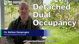
Major Update on Detached Dual Occupancy in the Hawkesbury
There have been many important developments on the question of permitting Dual Occupancy in the Hawkesbury, and I promised you an update.
This advice is currwent at July 8th 2026, and follows many other updates I have given in the past:
Granny Flats - You Deserve More Choice! (2021 - big explainer about why this issue is important)
Dual Occupancy - Approved in principle! (Labor opposes) (June 2025 - tracks the progress of the proposal I moved to progress the issue)
For example, you might have read that recently the State Government has issued its response to a NSW Parliament Upper House inquiry on this subject, so I’d like to give you an update.
This is one of the most common issues I am asked about, so I’d like to dig a little deeper and explain how we got here.
This video is a bit more technical than others I’ve made, but if you’re still watching I’m guessing you’re one of the interested ones.
Dual Occupancy is the ability to build a second house on your own land, without subdividing it. Your land remains under one title.
There are three kinds.
“Secondary dwellings”, otherwise known as granny flats are already permitted in these zones, but there are size limits, meaning they’re usually one bedroom, and they need to be close to the primary dwelling.
An “Attached Dual Occupancy” could be a second full sized house but it needs to be connected to the original house, like a duplex or connected with a common wall, a breezeway or covered walkway.
They are already allowed in these zones.
What isn’t currently permitted are detached dual occupancies – second houses, of any size, anywhere on your acreage block, and that’s something I’ve been going on about for a long, long time. If you want to know more, see my various earlier videos and especially this 2021 explainer on why I have advocated for this for so long.
I think it’s useful to know some of the history of this issue.
The earliest reference I can find to Council trying to permit Detached Dual Occupancy is November 2012, when Councillor Bob Porter failed to persuade the Chamber to allow Hawkesbury Council to have the same policy as Penrith already had, which permitted it.
He had another go with a motion in June 2014 that passed. It said we should amend our LEP to permit detached dual occupancy for all rural properties 5 acres and up.
That led to a report in 2015 and a refusal of the State government in February 2016.
The reasons given for refusal included flood evacuation concerns.
In both May and October 2016, more in hope than expectation, we asked again for “updates”, which I think details part of the problem – motions that just ask for information and don’t have any action words associated with them.
Councillor Peter Reynolds had a go in September 2017, suggesting that we might have more success if we asked to have Detached Dual Occupancy in just certain areas, like Oakville and Maraylya.
That also went nowhere.
In December 2021, at the very last meeting of my first term on Council, the chamber voted to endorse the form of a long delayed new LEP or “Local Environmental Plan” and advance it to a process called “Gateway” where the State Government gives it their tick. The LEP is our key planning document. It dates to 2012, and it’s completely out of date.
You can see from this document that the new LEP included another go at getting Detached Dual Occupancies approved in Rural Zones. It was our best chance to finally get it up, and crucially, we were told that the State Government were finally on board.
Many, including me were baffled when, in literally the first meeting of the newly elected Council in January 2022, a combination of Liberal and Labor Councillors joined forces to pull the LEP back. I likened it at the time to trying to take a newly launched ocean liner and pulling it back up onto the slipway.
Those Councillors said the delay was to let an obscure group called the LEP Reference Group, which included property developers, to meet with Councillors. They suggested that they had not been given a chance to give us their advice. This, despite the fact that the reference group had met ten times since November 2020 to provide guidance into the final wording of the LEP.
Months later, the group finally met with us… and told us they did not understand why the LEP document had been pulled.
It remains my belief that if the Chamber had not caused the unnecessary delay, the new LEP would be in operation right now, including Dual Occupancy. In my opinion, delaying the LEP was an act of vandalism.
Fast forward four and a half years and the new LEP is nowhere to be seen, without even a forecast date from staff. It’s an embarrassment.
In June of 2025 I moved my own motion before to take action in an attempt to finally make progress.
If the huge LEP was constipated, let’s try laser micro-surgery.
My goal was simple: Take every zone where Attached Dual Occupancy was already permitted in the current LEP and remove the word: “Attached”.
That’s it. Remove one word.
The motion passed. The Local Planning Panel gave it their endorsement on July 17th. We voted again on August 12th to send it to the State Government’s Gateway process. It came back on November 13th giving us conditional approval to proceed.
This is, in the scheme of things, light speed and hopes were high.
The gateway approval told Council we had to do three things:
- Do some consultation with the NSW Reconstruction Authority and the SES.
- Place the policy on exhibition and finalise it before a deadline of 25th August 2026, and, crucially
- Consider the impacts of an upper house inquiry into dual occupancy AFTER our proposal came back from exhibition.
That deadline had no additional qualification. We were told to get it done.
So what is the Upper House inquiry?
Shortly after Hawkesbury moved our proposal, I started getting calls from other people telling me what a good idea it was.
Mark Hornshaw, an ex-Liberal, now Libertarian Councillor up at Port Macquarie Hastings Council successfully moved a similar motion inspired by ours.
In July 2025 I got a call from a state colleague, John Ruddick. He sits in the upper house as a member of the Libertarian Party, but he is also a former Lib and a good friend. By the way, you might note that the common theme here is that if you want to get anything useful done in the world, leave the Liberal Party. But that’s a discussion for another time.
He successfully pushed for the NSW Parliament to hold an inquiry into Dual Occupancy with remarkable bi-partisan support. With John as the Chair, they deliberated from October to December. John and the committee came to the Hawkesbury and we spoke to residents who want to build dual occupancies for their adult kids, for their elderly parents, or to build farm accommodation to keep our agricultural lands viable.
Our Council officials and local advocates like Troy Myers explained at public hearings what we were doing, and the inquiry produced its report on the 30th of March.
Most recently, the NSW Government has made its own response to the Inquiry’s report on June 30th.
Now why is this important?
There are three ways that residents in the Hawkesbury are going to get some changes to their ability to site a second detached dwelling on their land, under one title.
And it’s a race to see which one bears fruit first.
Now we can see the government’s response, we can see they have given in principle support for secondary dwellings and dual occupancies in these zones (gesture) as what’s called “Compliant Development” through the Housing SEPP and some other SEPPs. SEPPs or “State Environmental Planning Policies” take precedence; they gazump whatever conditions our Council’s LEP has in effect.
For people who have illegal or unapproved Dual Occupancies (and there are a lot of those in the Hawkesbury), the Government was more muted about there being an amnesty, only saying that the inquiry’s recommendation was ‘noted’. This doesn’t mean there is no hope for people wishing to regularise dual occupancies they already have on the sly, but that the government will ‘consider’ the implications. Stay tuned.
If the NSW Minister for Planning, Paul Scully decides to act at State level to implement the recommendations of this Inquiry, some parts of what we’ve tried to do locally become moot.
The second track is for Hawkesbury Council’s proposal to be exhibited, attract community feedback, come back, and then be voted on before the end of the year and become an active policy.
I’ve pushed Council staff regularly about whether we will meet the August 25 deadline set for us, and I’m disappointed to say that the most recent advice back is that we will not. Staff are telling me this will be pushed out to Christmas.
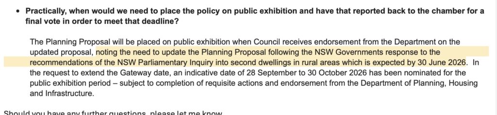
I’m very unhappy about that, because the reason they are citing to me for the delay is because of the “need to update the Planning Proposal following the NSW Governments response to the recommendations of the NSW Parliamentary Inquiry”
That’s the one we’ve just been talking about.
However, look! The gateway approval we received from the State told us fairly clearly not to do that. It told us to get the document out onto exhibition and tweak it to include these impacts AFTER it comes back from exhibition.
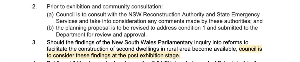
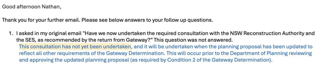
Worse, I’ve been told that the other work, the consultation we were told to do back in November with the NSW Reconstruction Authority and the SES has not happened. We could have acted on that seven months ago.
I have conveyed my disappointment to the Mayor.
Then there is the third and final way we might see movement, and that is through the new LEP, which is now eight years late, finally emerging from the mist.
That process is now so laughably delayed I don’t even know what to tell you. There is no date, and no pre-requisite condition anyone has been able to tell me that might let us all know when it will be presented to the chamber for approval. Don’t hold your breath.

I am approached regularly by people who just want this reform to happen so that they can look after their parents with dignity, or give a leg up to their adult children to stay in the communities they feel an affinity for, but without keeping them crowded under one roof.
At a time when there is a crisis in housing affordability, where the costs of rural living are eased by facilitating multi-generational households, and where people should enjoy the flexibility of building on their own land, all I can say is that I will continue to advocate for you.
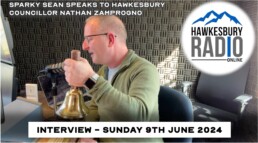
Interview on local radio Hawkesbury Radio with "Sparky Sean" Carroll
I sat down with "Sparkie Sean" from Hawkesbury Radio to talk about a range of issues. The wonderful Hawkesbury Gas-lamp festival, development, the Lower Portland Ferry, and the political environment in the current Council are all discussed.
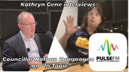
Interview on local radio Pulse FM with Kathryn Gene
On Monday Pulse 89.9FM Radio presenter Kathryn Gene interviewed me on air about local issues in her segment ‘In Topic’.
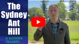
Should the Hawkesbury become part of the Sydney ant-hill?
The March edition of the Hawkesbury Post contains a text version of this article. This video version is intended as a richer, shareable version.
.As a high school teacher, I like to run a lesson about an obscure concept called ‘the Tragedy of the Commons’.
It starts with buying milk at the shops. There you are in Coles or Aldi. Two bottles of milk sit next to each other, one with a use-by date five days from now, and another with ten. You know that you’d easily get through either bottle before the due date, but you do what most people would do, and reach for the freshest milk regardless.
Economists have long known that this is how people behave. Understandably, people make decisions that are best for themselves in that moment; the broader good of society isn’t on their mind.
The problem comes when everyone makes those ‘best for me’ decisions. In our example, perfectly good milk just a couple of days older gets left on the shelf until it ages past its use-by, spoils, and is thrown out.
I offer my students this metaphor as a stimulus, not merely to give them a complex about buying milk. I encourage them to find connections between the story and larger, more serious real-world issues. When we over-fish the oceans, power our society with resources we know will someday run out, overuse antibiotics, or sacrifice agricultural land for housing without regard to the sustainability of these choices, then we are playing out the same ‘tragedy of the commons’ on ever larger stages. Our individual decisions remain rational and yield us short term ease and comfort. But they are collectively bad for our descendants because the bill is generationally deferred.
This is never more obvious than when we consider Sydney’s boundless addiction to urban growth.
Former Labor Premier Bob Carr famously declared that Sydney was “full” back in 2000. Since then, Sydney has grown by another third. That’s over 1.3 million people. Carr’s successors in the current Labor government manifestly no longer share his assessment, secretly targeting a range of suburbs for massive new growth and unprecedented densification. Are we next?
The risks of fire and flood strongly bracket what kind of growth the Hawkesbury can endure. Hawkesbury Council’s housing policy suggests we could build more medium density housing around our major centres of Windsor and Richmond.
However, State Planning Minister Paul Scully is sending conflicting messages to us, writing on the one hand to our Mayor to enjoin us to do our share in creating 377,000 new housing commencements by 2029, and yet warning us that a new Floodplain Evacuation Study places strong constraints on how much development the Hawkesbury can sustain. I think we need much clearer guidance about what is being expected of us.
Many of you now face a daily multi-hour commute, plus an annual toll bill running into the thousands just to get to work. The alternative is to brave our rail line which lacks a promised connection to the Metro at Schofields, offers no express trains, poor parking, and which has had no upgrade since electrification in 1991. Already-approved housing developments will only exacerbate this problem – lamentable considering we are still catching up on the infrastructure necessitated by the last decade of growth.
Worse, the Hawkesbury’s youth are being squeezed out of their ability to remain in the communities that they grew up in and feel an affinity for, increasingly unable to afford to either buy or rent. Many are forced to move away, increasing social isolation and losing the benefits of family support.
Council could do more to ease this by implementing affordable housing mandates in new estates, diversifying our housing mix, and permitting more generous granny flats and secondary dwellings on house blocks under one title. I have supported such changes, but progress has been far too slow.
However, the biggest factor in this squeeze, and only grudgingly admitted by politicians, is Australia’s level of migration.
A post-COVID surge saw a record-breaking annual 615,400 arrivals to mid-2023. After accounting for departures, deaths and births, overseas migration represents 77% of Australia’s population growth (data: Federal Centre for Population Projections).
Astonishingly, in NSW the figure is closer to 98% (data: .id research, Dec 2023). Read that again: 98% of all the pressure for new housing, associated infrastructure and congestion in Sydney comes from overseas growth. Think about that when you’re stuck in traffic, and for heaven’s sake, think about it when you vote.
Governments at every level have had this infatuation with ‘growth at any cost’ since the end of World War 2, spurred by some economists, developers and their lobby groups. For example the Urban Development Institute talks incessantly about the need to unlock land supply, fast track approval pathways, lower infrastructure co-contributions while increasing the density and height limits on tenements.
All these factors affect the supply side, yet they studiously ignore the demand side caused by migration. They ignore a fundamental truth – No growth is limitless. In biology we call a body that seeks to grow without bound ‘cancer’.
Sadly, Labor and Liberal governments have been happy to march to this tune. They claim that housing unaffordability is the price we pay for the stimulus to the broader economy, and to the construction sector in particular. These and other concerns like balancing the intergenerational ratio of taxpaying Australians to retirees and pension recipients are valid, but if there are winners and losers in such national tradeoffs, too many of the losers seem to be concentrated at the outer fringes of our major cities, where we suffer congestion and crushing cost-of-living challenges.
Skilled migration should be a part of Australia’s future, but 615,400 arrivals – most of whom gravitate to Australia’s major cities, is too much. It would be prudent to reduce migration until the infrastructure backlog is addressed, and proper incentives formulated to encourage new arrivals to settle in Australia’s regions. It’s disgraceful that despite this elephant in the room, successive governments have never set a population target, or properly investigated what Australia’s ‘ideal’ population or rate of growth should be. Every study you’ll read merely attempts to reactively model the low, medium and high growth scenarios that ‘might’ happen because there is no population policy, and never has been.
If you drive through the ‘instant suburbs’ that have sprung up near the Hawkesbury, we see a style of development that is neither pleasing to the eye, nor representative of anything we should seek to emulate. Tiny blocks, no eaves, no trees, black roofs. Nevertheless, I have a growing folder of examples of realtors hawking nearby greenfield lands in the Hawkesbury to developers, tantalising them that these lands too will inevitably be rezoned and absorbed into the Sydney anthill, yielding much profit to their investors. Beleaguered landowners are faced with an invidious choice; be taxed off their land when speculation triples their land value (and therefore their rates), or give in to land-bankers who don’t care about the erosion to our sense of community.
Hawkesbury residents deserve more agency in determining the shape and scale of development in our city, rather than be carried along in the current of a fatalistic belief that more urban sprawl can’t be avoided, and will continue forever. In such a historic and beautiful area, we deserve better, and we owe better to our successors.
That process starts by ensuring that the elected representatives in our Councils and Parliaments are not in the pockets of developers.
Like the dilemma facing you in the milk aisle, our ‘tragedy of the commons’ is our addiction to unfettered growth. It might serve a logical, beneficial short term goal, but it is gradually undoing the threads of what it is that makes the Hawkesbury such a pleasant place to live.
The video version contains video courtesy of Sustainability Population Australia.

The NSW Government's push to build 8 story flats in your suburb

The NSW Labor government is targeting a range of suburbs for massive new urban growth and unprecedented densification. They’ve announced a proposed policy of massive flat-building to meet a target of 377,000 new homes by 2029.
For those who wonder what the proposed rule changes could look like in the Hawkesbury, check out this map, presented to Councillors at a recent briefing.
We discussed this at Council last night and voted overwhelmingly to oppose this.
Here’s what the changes propose:
Three zones are identified: “Town Centres” (most of our larger suburbs); “Commercial Centres” (Windsor and Richmond), and all train stations (6 in the LGA).
If the new rules pass, Councils would lose the right to refuse new flat developments of up to 21m (up to 8 stories) within 400m of such zones and 16m (5 stories) within 800m. “Cookie cutter” designs from an approved “Pattern book” would enjoy expedited approval, tending to favour bland sameness in designs built to maximise profit.
Some buildings would only mandate 0.5 car spaces per dwelling.
Worst, these rules would summarily override Council’s LEP and DCP controls.
This is spectacularly rotten policy that fails utterly to understand the character of the Hawkesbury. Residents have told us for decades that our semi-rural outlook is a key factor in our charm and desirability as a place to live and work. The State government has failed to provide enough detail for us to respond to their demand for a detailed response. For example, the interaction of the proposed policy with known constraints in our area caused by flood, flood evacuation and fire risk has not been explained at all.
Former Labor Premier Bob Carr famously declared that Sydney was “full” back in 2000. Carr’s successors in the current Labor government manifestly no longer share his assessment. Yes, there is a housing, and housing affordability crisis. But I’d prefer the government was more honest about admitting that fully 98% of the pressure for housing growth in NSW comes from overseas migration and not from the organic growth of our own populace. This is something I will have a lot more to say about soon.

The debacle that is the Grose River Bridge project
When the Redbank developers promised they'd build a bridge across the Grose River back in 2012, they said the bridge would be completed by the time the development had sold 641 lots.
It's now ten years later, the Redbank estate has sold over 700 lots, and not a single sod has been turned. Most of the blame lays with Council, who inked a weak planning agreement with the developers, and who then changed their mind about where they wanted the bridge and approach roads to be built when the first location was recognised as a poor choice.
I've had a lot to say about this before, and last week Council faced the latest twist. Finally, a revised route and agreement has been placed on exhibition, but some, like the Wilcox family reported widely in the media, are facing a heavy cost.
I am not satisfied that we have explored every option to both get the project back on track, and to spare homes from unecessary demolition. Public submissions on the new VPA are invited now.

The family home flooded because they live next door to development
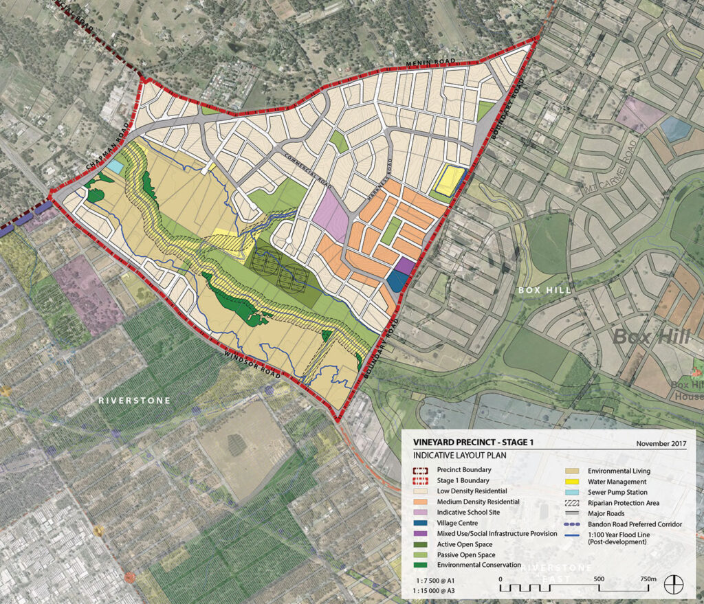
James and Nadine lived in Harkness Road in Oakville, squarely in the area we call Vineyard Stage 1, a location of intensive subdivision caused by the North West Growth Sector.
Their home was nearly, but not quite at the top of a hill. The developers over the road had already razed the houses that had stood there since the 1970s – family homes that had stood on acreage properties at the crest of that hill, and had eaten into the land like you'd take the top off an egg.
Prior to the bulldozers arriving, rainwater drained off the top of the hill equally in all directions. But since the excavations began, the hilltop opposite was now a shallow, muddy basin. But that basin now had a spout, and the spout was pointed squarely at James and Nadine's home, which sat at the bottom of a sloping driveway.
When the rains came in March 2022, that water filled the basin, which had been constructed with no sedimentation control, and poured out of its lowest point – the spout opposite their home. A muddy slurry ran through their home to a depth of some inches. James and Nadine's property were ruined, and they estimate the damage into the tens of thousands of dollars. Recent arrivals to the home, they had not yet taken out insurance.
This story is a tragedy. It parallels that of many other Hawkesbury home owners on lower land whose houses were also flooded out by the rising of the river to 13.7m at Windsor, a height not seen since March 1978.
But James and Nadine's story is distinct in two respects. The first is that this house had stood there for decades, and the elevation in Harkness Road meant the property had never flooded before. It was well above the riverbank properties that flooded in early 2021 and March 2022.
The second reason, and the reason James and Nadine have engaged me to advocate for them, was the substandard response they had received from Hawkesbury City Council.
James and Nadine never wanted to go public with their story, until months had elapsed and they came to the conclusion that publicity was the only way they could get answers to their questions.
Timeline:
First week of March - rain event, home flooded.
Second week of March - Council contacted seeking help
25th March - Clr Lyons-Buckett and myself contacted about non-response from Council.
28th March - I attend the Harkness Road property and record video, part of which is in the main video above and which was sent privately to Council staff to lay out the problem clearly.
12th April - Clr Lyons-Buckett and myself speak directly to the General Manager after a Council meeting to ask for a response. One is promised.
20th April and 13th May - Having had no response from Council, Councillors are again asked to chase the matter. I speak to our Director of Planning by phone.
13th May - An email from the General Manager to James and Nadine says "I’ll follow this up with my team and get back to you as soon as I can."
June 3rd - James and Nadine decide to go public given the complete lack of a satisfactory response from Council.
June 14th - The Hawkesbury Post makes a media request directly to Council. It is not answered by date of this publication (June 21st).
Three months without a satisfactory answer. This is not good enough.
As a Councillor, I pledge to represent residents when they have issues with Council. I'm not here to defend Council when the level of customer service they deliver is not up to standard.
Who wears the liability here?
- Is it the developers? They've now written to James and Nadine and told them all communication needs to be through their insurers.
- Is it the contractors? The excavations they performed allowed water to pool on the site and pour through a home that had never flooded before. When I visited the site in March, no sedimentation controls were present. When I visited on June 3rd, I could see they had belatedly been installed.
- Is liability with Council? Were there conditions of consent that were not enforced.
I have been calling for reform within Council, especially in the area of our planning, compliance and enforcement divisions, for some time. This story just underlines for me how chronically under-resourced Council is in this area. I get more comments from ratepayers about this than many other issues.
I am bringing this issue to a wider audience because even as a Councillor I have been unable to get timely answers to my questions. Let's hope this does some good.

Granny Flats: You deserve more choice | Hawkesbury City Council
July 2026 update: Welcome! This 2021 post and video explains why I think this issue is important, but has largely been overtaken by more recent events. For the most current information see this:
Major Update on Detached Dual Occupancy in the Hawkesbury (July 2026)
Dual Occupancy - Approved in principle! (Labor opposes) (June 2025)
Original 2021 post follows below:
I want to talk about granny flats and dual occupancies, because the way that Hawkesbury Council currently treats them is insane.
A dual occupancy is just a fancy way of saying there are two houses on the same block of land, but under one title, one owner.
It’s not like a subdivision because there’s no rezoning, no sale, or separation of the ownership of the land.
There are two kinds of dual occupancies: Detached, where there’s two, separated full-size houses on the same block, and attached where two dwellings are connected in some way, like a Duplex.

I live in an attached dual occupancy here at Oakville with my family, where we have two houses which are connected by a covered walkway.
And here’s the crazy thing: At Hawkesbury Council, detached dual occupancies are forbidden because of, wait for it, flood evacuation risks. And that's regardless of whether you’re in Bilpin or Oakville, well out of harms way of a flood. But put that covered walkway in, and everything’s peachy. Totally fine. Permitted.
Detached dual occupancies are already permitted (with constraints) in many other Councils, like Penrith, Hills, Cumberland, Parramatta, Northern Beaches.
But it gets worse: People often get confused between Dual Occupancies and “secondary dwellings”.
Secondary dwellings are much smaller, only up to 60 square meters- which is little more than 1 or 2 rooms, and must be close to the primary dwelling. We call them “Granny flats”.
Now if you want to build a granny flat in, say Bligh Park, or Hobartville, in any of these residential zonings, on a block that’s under 800 square meters, apparently that’s fine.
But if you live in one of these zonings in a rural area, like a five acre block, 25 times the size of a house block in Bligh Park, the answer is no. You can’t. It’s not allowed.

This makes no sense at all.
During this this term of Council I have been the strongest advocate for reform of these rules, but I’ve been stymied by a lack of support among the other Councillors.
I’m seeking your support to continue this work through your vote in the upcoming election.
Let me explain why this is important:
For a balanced community, the Hawkesbury needs a mix of housing types. I’ve argued that dual occupancies confer a range of social benefits.
Your ability to put another dwelling on the land that you own could allow you as parents to give a leg-up to your kids to build a home, or get equity in the market, or to continue to live in the communities that they grew up in, or to enable grandparents to care for their grandkids.
On the flipside, it might allow you to look after your parents in their senior years with a degree of independence, but still close to those they love, sharing the burdens of property maintenance or the costs of living.
The way that my family lives exemplifies this: I live in a multigenerational household, with toddlers, teens, adults, seniors, spaniels and cats living together in a joyous chaos.
This 2020 article from the Sydney Morning Herald on multigenerational households really resonated with me.
I’ve heard this described as a very European way of living. It’s not for everyone, but for many families it makes a lot of sense. For some, it’s an economic necessity.
But ultimately it’s about choice. Your choice.
Studies show that one in five households are multi-generational, and that figure is growing (Source: City Futures Research Centre, UNSW Dept of Built Environment). And 40% of people in their twenties are still living at home (Source: Australian Institute for Family Studies).
To me, it’s an example of how something obscure – good planning laws, can strengthen our communities by empowering Council to plan for diversified housing choices with far less impact on existing services and infrastructure than full blown subdivision.
Others support secondary dwellings because it represents a form of affordable housing, which we badly need more of.
Lastly, we can’t ignore the fact that many acreage areas are and will continue to be subjected to development pressure. I. am.no.fan.of.overdevelopment.
But dual occupancies may represent a kind of happy compromise between the status quo, and the wholesale rezoning and carve-up that developers want to inflict on us.
Many people I speak to want a sensible solution like this, but I challenge you to find another Councillor that can point to a public statement they’ve made in support of it.
And you and I probably know someone in the area with a clandestine granny flat that’s offending nobody but against the rules.
In February this year, Hills Shire Council next door took advantage of a change in State rules, something called the ‘LEP Standard Instrument’ to apply for, and get, a more generous definition of Granny flats.
As a result, Hills landowners can now build granny flats that are still modest, but larger than before: whichever is the larger of 110 square meters or 20% the size of the main dwelling, up from 60 square meters.
I’d like Council consult and consider doing the same, using a place-based approach that’s sensitive to all the factors and constraints, like land fragmentation, loss of agricultural capacity, emergency evacuation, local roads & infrastructure and the protection of the environment.
As I said, I’ve tried to drive reform in this area and so far I’ve failed.
Our best hope is the detailed work Council has done this year in revamping our LEP and DCP – our two fundamental planning codes, but progress has been been painful and slow.
I’ve pushed for these proposals to be put into the new codes for public comment, but it’s the next Council that will sign them off.
I’d love to hear your views. What do you think?

Further delays to the Grose River Bridge should make you cranky
https://youtu.be/FuF-kUkjoSY
The Redbank project, and associated wrangling over the promised Grose River Bridge crossing goes all the way back to 2008.
So if you're angry or confused about why it seems that this infrastructure keeps receding to the horizon, then I'm with you.
Why is it taking so long? And why, after this week’s Council meeting, is it going to be delayed even more?
Here's what you need to know. This video lays out the timeline of this issue.
I have been on about this issue for this entire term of Council.
From 2016:
https://councillorzamprogno.info/2016/10/15/about-the-redbank-development-at-north-richmond/
And 2017:
https://councillorzamprogno.info/2017/04/10/about-the-grose-river-bridge-and-the-redbank-development/
Proposed McGraths Hill motel development knockback prompts litigation
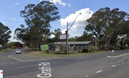
Those driving down Windsor Road from Windsor will be familiar with the former but beloved Millers Nursery (a.k.a Windsor Garden Centre) on the left hand side on the corner of McGrath Road at McGraths Hill.

Opened by Ross and Lynette Miller in 1969, and carried on by daughter Bec it was a stalwart local business for 47 years. I remember it as a cosy and personal ramble – a place with nooks, and curios, and proper service. Not at all like the bland 'big box' nurseries that prevail now. Ross was active in Windsor Rotary for many years. Sadly, the business closed and the property sold in July 2016. The site has lain empty and sad ever since.


I mention this today because the fate of this site reveals in microcosm two things: The first is how Hawkesbury Council still has a long way to go to be a responsive, efficient public body that meets deadlines and applies our planning codes consistently. The second is how planning laws imposed by the State Government have disconnected the community from knowing much about, or having much say in Development Applications.
In 2017, the NSW Government instituted Planning Panels to determine DA's, removing the decision-making powers of elected Councils across Sydney. Planning Panels consist of unelected appointees who may have subject expertise in planning, but who are not democratically accountable to you, the citizen and voter. I and many other Councillors, including some Liberals were opposed to Planning Panels, and I've spoken at length about them before, including with 2GB's Ray Hadley.
A series of DA's have been lodged for the old nursery site to become a motel development. A pre-lodgement meeting held with Council in February 2018 indicated a desire to build a $10.8 Million, 130 bedroom motel.
DA0235/18 was lodged in May 2018 proposing a 94 room motel.
A decision on this proposal now sat with the Sydney West Planning Panel, with Hawkesbury Council staff writing a report with a recommendation for or against.
Council's report to the Planning Panel did not arrive until September 2019, over a year later. This kind of delay is itself an issue for me. Such determinations should not take so long. In October 2019 that application was knocked back, for a variety of reasons including the ability of the McGraths Hill sewerage treatment plant to cope with the load the development would place on it.
The applicants then came back with a new proposal for an 80 room motel under DA #0130/20, lodged on 13th May 2020.
I suspect not many people, even residents of McGraths Hill, knew much about any of these proposals.


76 days later, on 28/7/2020 the applicant made an application to the Land and Environment Court (case #2020/00226591) to litigate the DA on the basis of an assumed "deemed refusal", which means that the DA was not finalised or determined either way within the prescribed assessment period (which can be either 40 or 60 days).
Recently, on 31/5/2021 the application was withdrawn and a request for a refund of DA fees made, but only because this litigation was, and remains pending. A hearing may not occur until September.
In their letter withdrawing the DA, the applicants offered this stinging commentary to Council:
"It is with disappointment that we note that a lack of transparency from Council in relation to Council’s sewerage capacity issues and a lack of response from Council officers (who are too busy) in relation to the proposed on-site waste water system - which have prevented us assisting to achieve a satisfactory resolution of this development proposal."
I offer no commentary on the merits of the proposal, except to note that all applicants to Council are entitled to prompt and professional service within "best practice" assessment timeframes. If they didn't get it, I'd want to know why.
But my broader point is that, when decisions that shape the character of our neighbourhoods are taken away entirely from your elected Councillors and given to planning panels, the community ends up poorly informed (did you know about this?), and decisions are taken that you can't require anyone to be accountable for, and that's not good enough.

Sending a strong message about inappropriate development at Kurrajong and Kurmond
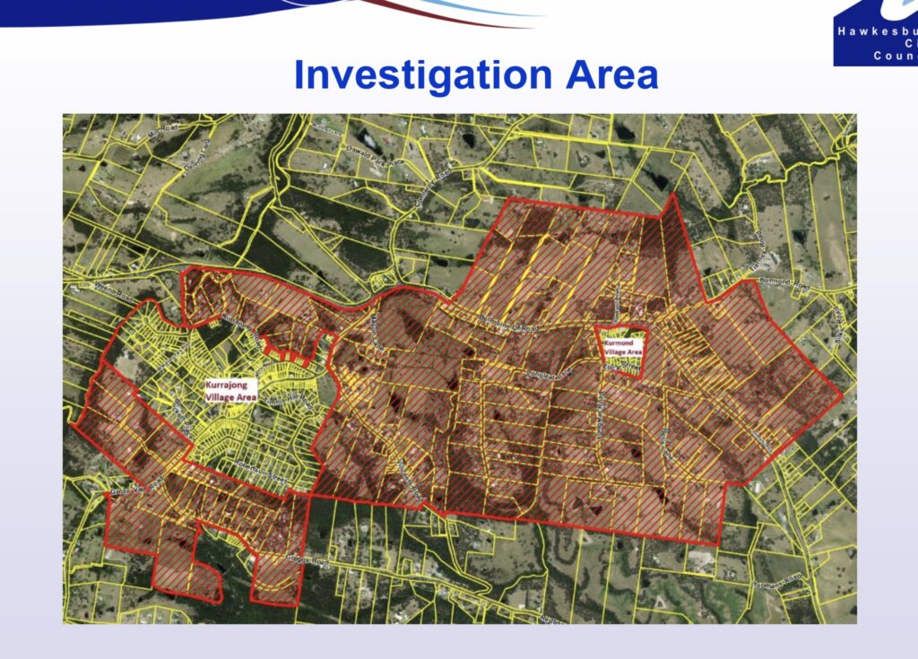
At Council's meeting this week, I supported a motion to end the ‘Kurrajong-Kurmond investigation area’ process.
I believe the proposed rezoning and adoption of the 'Structure Plan' would have encouraged the lodgement of further subdivision proposals. I felt it would have sent a message to landowners or developers that we were encouraging subdivision west of the river.
The motion Council passed abandons either rezoning or the Structure Plan, adding that Council 'Not encourage the lodgement of additional individual Planning Proposals within the Kurmond- Kurrajong Investigation Area for rural residential development.'
The motion ensures already-lodged planning proposals will be granted due-process, and continue to be assessed against relevant criteria.
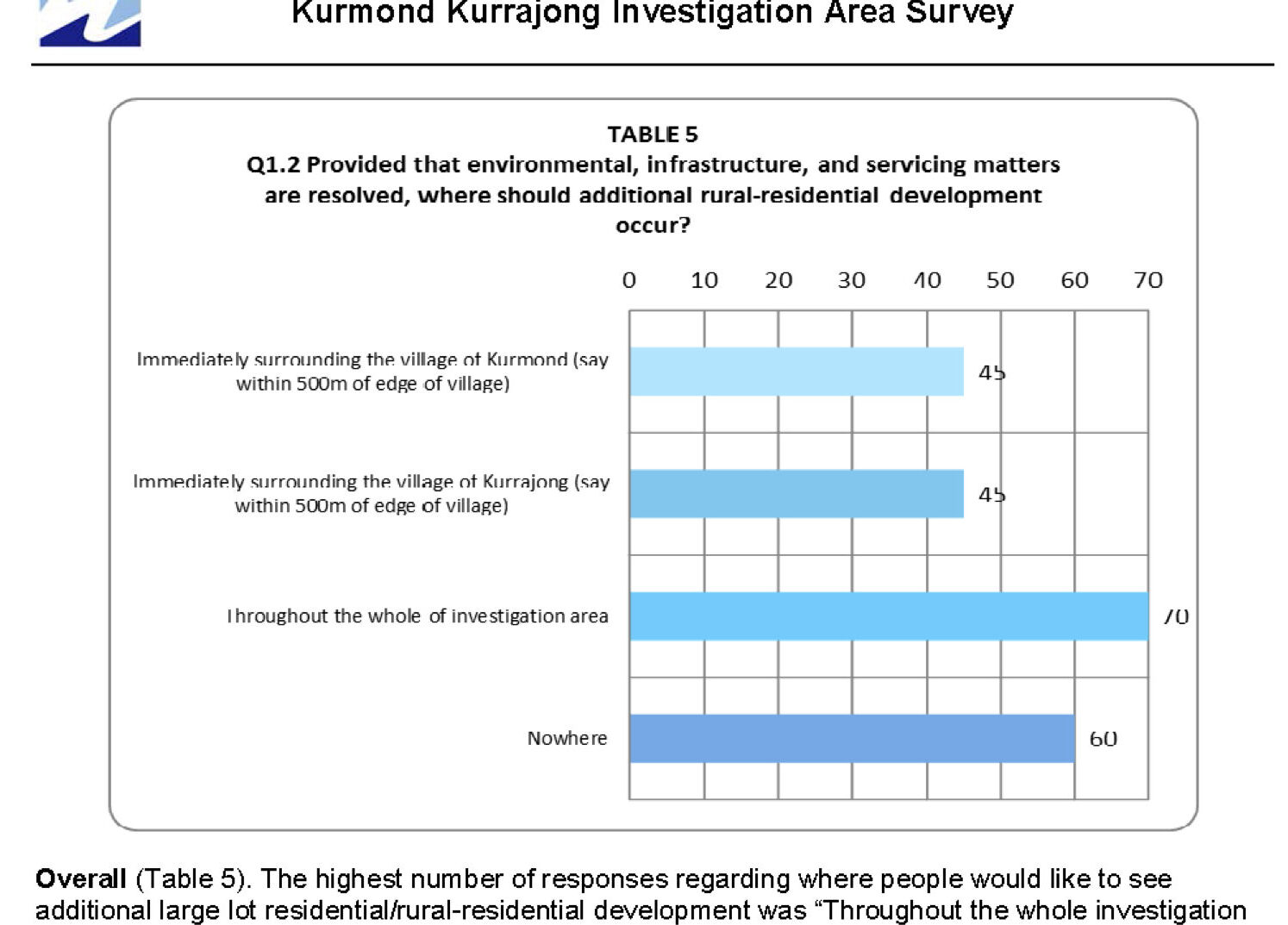
A 2017 survey of Kurrajong and Kurmond residents showed that only 32% of residents supported developing the whole investigation area.
Although it is true that anyone can submit an unsolicited proposal at any time to subdivide their property, they will still be assessed against increasingly strict criteria of both our LEP and the Greater Sydney Commission's residential strategy.
Two Councillors recused themselves because they or their families, live or own property in the subject area, including Liberal Sarah Richards.
Extraordinarily, the Greens and Independent Councillors voted not only to adopt the structure plan, but to have Council prepare a planning proposal to rezone the land identified in the plan.
We encourage those with an interest in the debate to listen to the Council webcast.
Hawkesbury Radio interview, February 2021
This week I had the pleasure of sitting down with Garry Cotter at Hawkesbury Radio 899 to talk about my personal opinions on a wide range of issues.
The fate of a concrete recycling plant continues to be of concern to residents of Ebenezer, and I had an update concerning an upcoming planning panel meeting, along with remarks about the deficiencies of Planning Panels generally.
As a member of Council's Civics committee, I congratulated our Australia Day award winners.I put on my hat as the Chairman of the Hawkesbury River County Council and raised a concern that key aquatic weed control activities are at threat because of a bad funding decision by the NSW Government.
I spoke about some very recent changes to a proposed 580 lot subdivision at the Jacaranda site (off Kurmond Road at Glossodia).
Finally, I spoke about the ongoing pressure for development in the Oakville, Vineyard and Maraylya areas, and efforts I've made to consult with that community.
Timecodes:
0:00 Concrete Recycling Plant, Ebenezer, and Planning Panels
8:06 Australia Day award winners
10:01 Hawkesbury River County Council, State Government Funding fail
16:34 Council Committee Restructure and the Heritage Committee
21:24 Proposed Development at Glossodia -Jacaranda
28:00 The Pressure for Development in Oakville, Vineyard and Maraylya

Hawkesbury's Local Housing Strategy and the pressure for development
On Tuesday, Hawkesbury City Council adopted our long-awaited Local Housing Strategy.
This document sets out how we will meet our housing targets over a timeframe of several decades.
Although this has implications for our whole city, the Liberal Councillors felt it was important to address a gap in the document.
The south eastern part of our City – the suburbs of Vineyard, Oakville and Maraylya, sit adjacent to some very aggressive urban growth. The ‘North Western Growth Sector’ is breathing down our neck across the county line in the Hills District, and has spilled into our own patch as the release areas named ‘Vineyard Stage 1 and Stage 2’
This pressure is tearing our community apart. Some are in favour of development, many against.
The one thing we can’t do is… nothing. I was disappointed that the Housing Strategy document said little about either the necessity, desirability, inevitability or show-stopping constraints of future development, other than remarking that the not-yet-finally-gazetted Outer Sydney Orbital corridor will continue to hang over us until that matter is definitely resolved.
I have strong opinions about this, but they matter less than seeking to understand what the majority view in those suburbs truly is. Some individuals or groups might claim to represent a clear majority, but I don’t think they do. I have a responsibility to represent all those views, and I take that seriously.
So, we moved a form of words that sought to survey and consult with the residents of Oakville and Maraylya to ask them what they wanted. Nothing more. Certainly not a decision to develop or not.
Your Liberal Councillors voted for that consultation. All the others, including Labor and the Greens, voted against it.
This video only contains my remarks, but I encourage you to listen to the whole meeting podcast (item 247, 8th December meeting) when it comes out to hear from my Liberal colleagues and the others.

Straight talk about Development
I was with Garry Cotter being interviewed at Hawkesbury Radio and the subject turned to development in Sydney generally, and the Hawkesbury in particular. How can we balance the destruction of urban sprawl with Sydney's need for housing?
On reflection, I thought this two-minute segment sums up where I'm coming from.
Where do your other Hawkesbury Councillors stand on this and other issues?
Do they ever publish? Make videos? Do interviews? Speak publicly?
You're entitled to know where your elected representatives stand on issues. If you want my view on an issue that isn't already written about on this site, just ask.
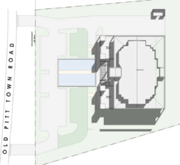
Is a Hindu temple appropriate for Pitt Town?
A number of residents have approached me about a development application which was lodged in late November for the construction of a $6.4M temple complex at 95 Old Pitt Town Road, Pitt Town.

The image below should provide some context: In the upper left is the Pitt Town cemetery and in the lower right is Pitt Town Sports Club.

The application as submitted to Hawkesbury council requests permission to

Council's DA Tracker website has the details (use DA0513/19 or the address as the reference). The application has been initiated by a group called Sri Mandir who are based at Auburn. They appear to be a different entity to the organisation who successfully sought permission to build a Hindu temple at Beddek St in McGraths Hill in October 2016. That group is called Sri Siva Jyothi Temple, who are based at Wentworthville.
With respect to the 2016 DA, this occurred during the time when Council was the consent authority. On that occasion I voted against approval, and the public remarks I made as to why are on the public record.
The Hawkesbury Social Atlas shows that at the time of the 2016 Census, the Hindu population of the Hawkesbury was 0.2% (130 individuals), vs 3.5% in the Greater Sydney area.
It would appear that the D.A is for a very ostentatious structure, being multi story and with 67 car parking spaces. The structures are "forward" on the subject block, and close to the road.


The residents who have approached me have expressed a range of concerns about the appropriateness of this development for this site, citing traffic, scale, noise, fire hazard and the effect on amenity. The development sits quite close to Scheyville National Park, as detailed in the Bushfire Assessment Report.

Under changes to NSW Planning, Hawkesbury City Councillors no longer vote on DA's before our Council. These planning powers were removed from many NSW Councils and given to unelected, unaccountable "Planning Panels". I and many other Councillors (Liberal and non Liberal alike) are opposed to this diminution of democracy in our planning laws.
Planning Panels may empanel people with eminent subject expertise in planning matters, but in our democracy, the expertise of public servants must be balanced with democratic accountability to the community.
If a Planning Panel makes an unpopular decision, frequently they have no "skin in the game"-- they can't be voted out by the public, and in some (not all) cases, don't even live in the communities they are affecting by their decisions.
Details about the Hawkesbury Local Planning Panel are at Council's website.
Hawkesbury Council has at least some part to play however. They act to receive and process paperwork related to DA's, and before the Planning Panel meets, will write a staff report either listing the consent conditions that should be applied, or alternatively, recommending refusal and citing the ways in which the DA would be inappropriate in that zone or at that site.
Residents have also expressed concern that the exhibition period, occurring over Christmas, and during a time of significant duress within the community with bushfires, has not afforded people enough time to digest and respond to the proposal. There is also a report (unverified by me) that not all the documentation currently on the DA tracker was made available in a timely fashion.
I think a public meeting should be held so that residents can receive information and understand the implications of this proposal.
As was the case with the McGraths Hill proposal (which curiously has not broken ground on their land since consent was granted in October 2016), I will be happy to support local residents as they seek representation to the Planning Panel, which will meet later this year (date unknown) to consider it.

The Vineyard Development area
Recently I completed a trio of short videos that go together in covering issues relating to housing development.
My desire is to touch on larger issues affecting our city and its future growth, but I use the example of the proposed development of the Vineyard area to illustrate them.
They cover:
- The extent of the Vineyard development in the context of the North West Growth Sector
- The role of both developers, the State Government, and Councils have in funding and delivering infrastructure
- The role of IPART, the Government's independent pricing regulator, in adjudicating whether Council's infrastructure plans are economical.
Here they are together.
Part 1: Development and Congestion in Hawkesbury City
Part 2: Who should pay for Infrastructure when housing development comes?
Part 3: Don't let population pressure tear our community apart.

Demanding clarity on the future of the Hawkesbury

(Edit-- 27th June: The motion I put to Council on the 26th passed 11 votes to 1. Audio of the debate can be accessed below:)
Original post:
The whole messy process that has unfolded since March about road corridors has brought the issue of development in the Hawkesbury into focus.
Everyone can see the massive surge of housing and commercial building that has marched down Windsor Road and is now knocking on our door. Indeed, some of this urban development is even now in our Council area, because the "Vineyard Precinct" of the North West Growth Sector (NWGS) is within the Hawkesbury City boundaries.
Residents and landowners on acreage properties adjoining the NWGS are justified in their concerns that this development will eventually overtake them as well. Everyone is entitled to some certainty about their future on the land, which includes some of the Sydney basin's diminishing stock of prime and currently productive agricultural land, plus remnant Cumberland woodland.
As a Councillor, I've tried to apply pressure to planning officials with the State Government to be honest and co-operative about what the long term future of these areas are, largely defined by the suburbs of Oakville, Maraylya, Vineyard, and even parts of Pitt Town and Cattai.
What I've received are mixed messages, and this isn't good enough. Some of the documentation associated with the Outer Sydney Orbital hints at areas "north of the Vineyard Precinct" for some kind of industrial use. The "SEPP", a planning zoning that makes the NWGS possible, actually encompasses a far larger area that the current development. Speculators -- real estate types and developers -- are fomenting rumours about currently rural areas being re-zoned for future development and this is inflating prices, which inflates land value, which inflates your rates. I've said more about this in the video I made about the corridors proposal. Check it out.
The consequence is a persistent sense of dread, and an inability for residents to know what their future looks like, even while they are being rated out of existence on the properties that they bought with a working wage, and wanted to retire on.
Council has a particular responsibility here. Later this year we are renewing what's called our "Residential Land Strategy". This exercise will set out Hawkesbury Council's desires for what areas will take what degree of development over a longer timeframe. Regardless of where you sit on the question of growth, Council needs to manage what could or should happen, and where. Here is the link to the current strategy, adopted in 2011.
In the RU2 and RU4 zoned acreage properties in the south eastern part of the city, our choices could range from "no change", to "detached dual occupancy" (meaning two houses on a five acre lot, but under one title), to "large lot rural subdivision" (like we see at Windsor Downs, with block sizes at a minimum of one or two acres), and then upward through a range of subdivision options that resemble what we see on the eastern side of Boundary road. I am emphatically not in favour of that outcome.
However, for Council to deliberate well, we deserve clarity from a range of state government departments, including the Department of Planning, Transport for NSW, and the Greater Sydney Commission. And of course, the public also have a right to know, and my gut feeling is that we have not had full disclosure from these agencies.
I am therefore moving the Notice of Motion you see below at the Council meeting next Tuesday (26th June), and I invite you to spread the word, come along, and register your support for this call for honesty and clarity about what the government's long term plans are for our homes.

The BLOR and M9/OSO Corridors, Part 2
This post is the second of two in response to a proposal to create two motorway and rail corridors through the Hawkesbury.
The first video provides some historical context to the broader phenomenon of State and Federal governments foisting large projects on unsuspecting communities. The challenge of balancing long term planning and the impact on individual communities has frequently been botched, and I cited the history of corridor sell-offs, and earlier proposals for airports, prisons, dumps and new suburbs, by both major political parties, as salutary examples.
What follows is a transcript of the video, with documents referenced on-screen linked or inserted as needed.
TRANSCRIPT:
In the first video, I provided a small history lesson about the litany of misguided schemes that governments of both hues have cooked up over the decades for the Hawkesbury, and how each one, after a fight from the community, was scuttled, and the government of the day had their asses handed to them, on a plate.
Today, let me be far more specific about the current corridor proposals. This video is also a part of my submission to Transport for NSW.
Point 1: Both these corridor proposals are equally bad.
It is true that the Bells line of road corridor has gained more publicity here in the Hawkesbury, including through a very well attended meeting at Clarendon showground a few weeks ago. But the fundamental problem of both corridors are the same.
Both corridors divide rural communities, destroy productive agricultural and equine lands, diminish visual amenity, endanger ecological communities and threaten the futures that families thought they had by buying homes outside of what I call ant-nest Sydney.
And both corridors suffer from the deficiencies of process that have landed these proposals on unsuspecting voters, without sufficient community consultation, without enough knowledge of the options to make meaningful contributions to the debate, and in a time-frame that is far too short.
The community has had barely 8 weeks to inform themselves and organise to have their say on projects that may happen decades from now. What’s the rush?
Point 2: The River crossing has to be back on the table

We are free to speculate that the government will change its mind about the Castlereagh corridor. It may default to the original 1951 alignment, and it may choose to stop at the Hawkesbury Nepean river instead of crossing over it.
If that’s the case, then the question of an extra crossing of the river must be back on the table.
I always believed that only someone as major as the M9 could deliver what we’ve always needed – a new crossing of the Hawkesbury Nepean River, somewhere between North Richmond and Wilberforce.
It turns out that we got proposals for two corridors, and neither delivered. The briefing Council received on the Castlereagh corridor actually suggested that it would help alleviate traffic on Windsor Road, by putting a new crossing of the river at Castlereagh, more than half the way to Penrith. Bollocks!
But what a huge political win it would be for the party that redirected the M9 along, say, the south creek floodplain, crossed the Hawkesbury river downstream of Windsor bridge, and joined it to the Putty road, providing a link to both the Hunter and Newcastle as originally intended.

Point 3: Why are both corridors roads to nowhere?
The Bells line corridor is irrelevant unless there is a major amplification of Bells line itself west of Kurrajong Heights and over the range. There isn’t anything like a compelling case for this given that billions have been spent over the last two decades to upgrade the Great Western Freeway.

And the M9 corridor konks out at Maraylya. Here’s what the terrain looks like between there and Newcastle. Mountainous terrain, National parks, wetlands, another major crossing of the Hawkesbury River, and well downstream, so the river is broader and deeper.

If there’s little prospect of the corridor being driven north of Windsor Road, why endure the political pain of taking it even that far?
Point 4: Why is the government’s material contradictory and incomplete?
Why do the government’s press releases and maps state that the corridor passes through Box Hill?

Below, the area in purple is Box Hill, in the Hills Shire, and on the left is the corridor. They are not the same.

Why does the draft EIS reference the M9 corridor as only running from Windsor Road and south to the Hume Highway at Menangle?

Why is the vegetation study in the draft EIS so incomplete?
I’ve created a tool in the program Google Earth. The online map that Transport for NSW provides is difficult to navigate and doesn’t allow you to leverage other geographical datasets and overlay them on the corridor.
This overlay I’ve created allows you to see the Hawkesbury ends of both corridors and toggle them along with other useful data, like alternative routes and a vegetation study.
There’s a link to this overlay at my website, along with a longer video tour of what it shows. All you need is the Desktop version of Google Earth for Mac or Windows, and that’s a free program.
Nobody else seemed to be doing this kind of analysis, so I thought I’d do my bit.
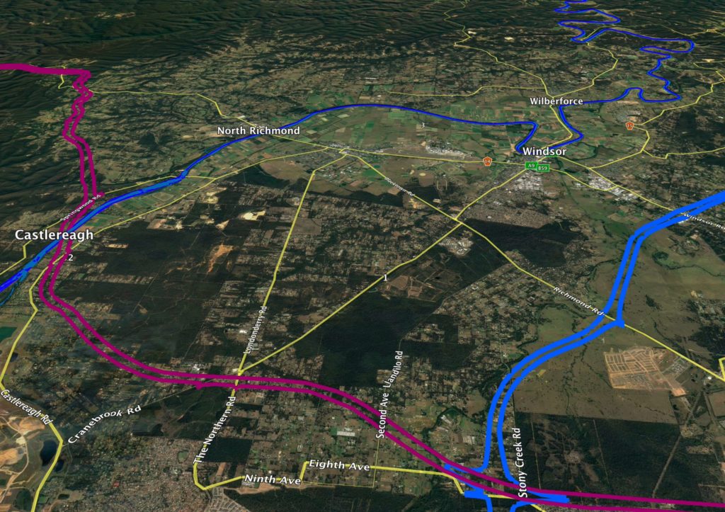
What you can see here is the area of the M9 north of Windsor Road, in Oakville, Vineyard and Maraylya. Here is an overlay of the vegetation study map that appears on page 96 of the OSO Draft EIS dated March 2018.

This looks a little muddy, but the green areas represent “Threatened ecological communities” and the hatched areas represent “Cumberland Plain Priority Conservation Lands”. Even from this map, it’s obvious that the M9 corridor goes through threatened ecological communities.However, what concerns me more is that this map is incomplete.

Here is a 2002 map from NSW National Parks overlayed on the same area. It shows many more stands of Cumberland Shale Forest – areas that just don’t appear on the Transport for NSW Map. And it’s not because there has been mass deforestation since 2002 – the amount of tree cover in this area has remained pretty constant over the years, precisely because landowners look after them as rural lands.
If I toggle the layers, you can see a huge difference. The draft EIS has massively underestimated the tree cover, and the conservation value of the lands under the M9, and it seems apparent that the BLOR corridor study suffers from the same defect.
Point 5: What is the future of this part of the Hawkesbury anyway?
The government can’t have it both ways. It says it needs to reserve this corridor through the area because of future land use pressures. But this land is currently zoned rural, for acreage properties.
Here’s the property on the corner of Old Pitt Town Road and Speets road – part of the Sydney basin’s diminishing store of productive agricultural land. It’s also smack bang underneath the M9 corridor.
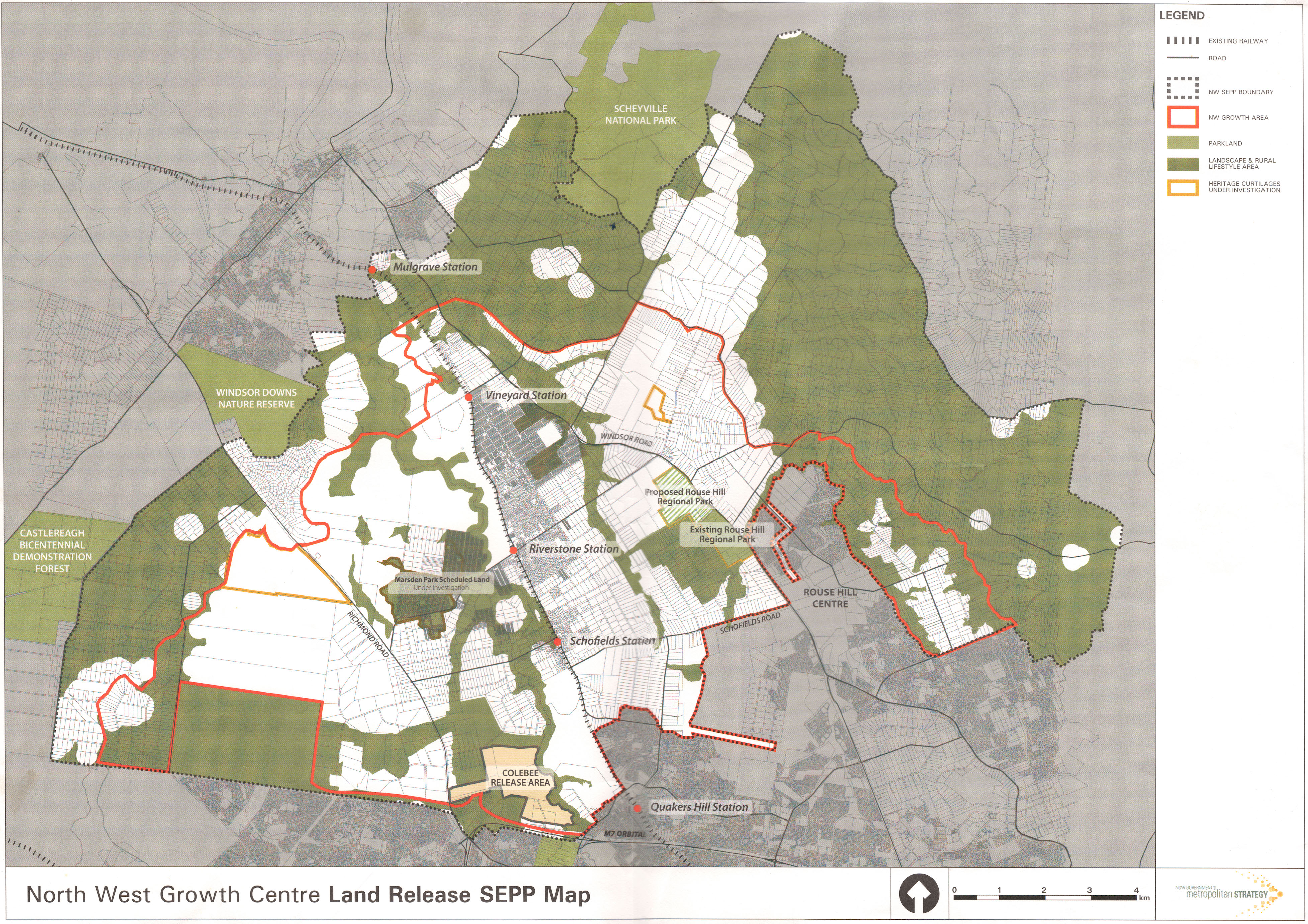
Here’s a map you’ve probably never seen. The red area is the area defined by the current North West growth sector. The part that’s in the Hawkesbury is this bit south of Commercial Road and Menin Road.
The outer dashed line represents the outer boundary of what’s called the SEPP – it’s the planning instrument that makes the North West Growth sector possible. It encompasses a much larger area – all of Oakville, the rest of Vineyard, most of Maraylya, and parts of Mulgrave and McGraths Hill.
Why stick a fuse in something unless you’re going to light it? We already know large chunks of land inside the dashed boundary, but outside the North West Growth Sector, are already subject to development, like this huge area north of Old Pitt Town Road. When will the other shoe drop?
Hawkesbury Council will be reviewing its Residential Lands Strategy later this year. I grew up in Oakville, and live there still. My heart is to protect our rural amenity and provide a buffer between the development at our door, and our agricultural lands, the National Park, and the remnant Cumberland Woodland that still exists outside the boundaries of the park.
But as an elected representative, I have to weigh what is best for the whole community. If there has to be development in the Hawkesbury, this is the area closest to Windsor Road, closest to the new rail infrastructure, not subject to the pinchpoints of the river and its inadequate crossings, and relatively flood free.
I’m calling on the state government to be honest with the community and to tell us if there are any plans to subdivide land outside the current growth sector boundaries.
For example, there's this from the OSO Draft Strategic Environmental Assessment, which says:
The Growth Area LUIIPs have assumed that the recommended corridor will be formally identified in the future, and will inform more detailed planning for precincts yet to be rezoned. For example, the DPE is considering land immediately north of the Vineyard Precinct as providing future opportunities for employment and industry related to the future OSO infrastructure, with detailed planning to commence once the location of the recommended corridor is formalised.
The areas north of the Vineyard Precinct are in Oakville and Maraylya, and are currently zoned "Rural". Questions I have asked of departmental officials about the long term future of Oakville, Vineyard and Maraylya have been met with silence.

Point 6: Why weren’t we told?
Minister for Western Sydney, Stuart Ayres made much of saying that the announcement of these corridors was already the culmination of plenty of consultation with the community. Bollocks.
Here’s a glossy document that came out in 2014, three years ago, titled “A plan for growing Sydney”. And in that document is the only map I’ve ever seen that shows, before this announcement in March, where the corridors may have been.

It clearly shows the possibility for these corridors to affect Castlereagh, Grose Vale, Yarramundi, Bowen Mountain, Kurrajong in the west; and Oakville, Maraylya and Vineyard in the East.
No one I have spoken to in any of those communities were consulted. Not one. And not Hawkesbury Council, to the best of my knowledge.
Point 7: There are plenty of alternatives.
I’m not a town or transport planner. Maybe you are. But why has the government placed one option for each corridor before us, and left it to us to suggest alternatives?
I feel inadequate to the task, but here are some starters.
Stop the corridor at Windsor Road.

Follow the South Creek catchment and cross the river downstream from Windsor (see map above)
Follow the alignment of the North West Rail Line extension corridor.

Or, there's this proposed solution from a road lobby group, Roads Australia.

Lastly, the funds could be diverted into local road solutions.
Point 8, and my last: Do not forget the political dimension.
I am an elected Liberal, and statistically, most Hawkesbury voters are Liberal voters. This isn’t a left-right thing – my last video showed you a long list of awful thought bubbles foisted on us by past governments of both hues.
But I lament that the bad way in which this issue has been handled by an otherwise praiseworthy state government has given a huge free kick to our political opponents.
The government has made a mistake in both these corridors. I can’t find it in my heart to attribute to malice what can easily be explained through stupidity.
The government simply needs to step back, realise it may well lose the next State election if it keeps this up, and without ego, change its mind – just as it was mature enough to do on the question of council amalgamations, greyhound racing, and stadiums.
I think it’s actually the mark of a good government to put things out there and then really heed criticism. It needs to do that now, because the damage has already been done.
Even if you’re watching this after the deadline for community submissions, which is June 1st, please let me encourage you to keep the pressure up, especially by calling and writing to the office of your state member of parliament, Dominic Perrottet, Stuart Ayres, and the Premier, Gladys Berejiklian.
My name is Nathan Zamprogno, and these views are my own. They are not Council policy and they are not the “Liberal Party line”, whatever that is. I’d love to know what you think.

A Google Earth overlay of the OSO-M9 and BLOR-Castlereagh corridors
In my videos on the OSO-M9 and BLOR-Castlereagh corridors (Part 1 and Part 2 are here) I reference a Google Earth overlay I developed that draws together data from a variety of sources.
My other posts do not tour the various layers that have been incorporated into the layout, so I made another short video to show you around.

Please note that my focus is on the northern extents of the corridors passing through the Hawkesbury LGA. My apologies if you have come here from the Camden locality looking for data on the southern extent of the M9. Perhaps someone down your way can do a similar analysis.
What is a Google Earth overlay?
You are already familiar with Google Maps. Perhaps you use the web based version on your browser or smartphone.
There is a more powerful standalone app called "Google Earth", which allows more sophisticated data to be layered on top of the general map, and layers can be toggled and edited.
The document format for an overlay carries the ".KML" or ".KMZ" extension. They are functionally the same. ".KMZ" files are simply compressed and take up less space.

How do I get Google Earth?
It's free! There are versions for Windows and Mac, and you can download them here.
There is also a version called "Google Earth Pro", and it will work, but the standard version is fine.
Can I use the version of Google Earth through the Google Chrome Browser?
Not to view my overlays. You need to use the app for Mac or Windows. You can't use the Google Earth App for Android or iOS, either.
Where can I get your overlay of the road corridors?
At THIS LINK HERE.
What do I do once I've got it?
If you have Google Earth installed, and you've got my file "M9_BLOR_Corridor_Analysis_Clr_Zamprogno.kmz"
then double-clicking it should bring it up in the Google Earth program as a series of layers and folder in the left-hand pane of the app. Experiment with toggling them on and off. You can do this individually or as whole folders.
Note that the layouts will come up with a splashscreen with my notes. It's the first thing you'll turn off by deselecting "Title Graphic" in the left hand pane.

The BLOR and M9/OSO Corridors, Part 1
This video is the first of two, and explores the history of government attempts to ride rough shod over the community, and what has tended to happen when they try.
It is intended to encourage people engaged in the current struggle to protect the Hawkesbury from two destructive corridor proposals to recognise that these kinds of things have come along before, and the community has generally won.
The second video will be more specifically focused on the reasons why the current proposal is a bad idea.
Transcript:
In this video, the first of a two-parter, a history lesson about why the government's proposal to drive motorways through the beautiful vistas of the Hawkesbury is deja-vu, all over again.
I’m Nathan Zamprogno, one of your elected Liberal Councillors on Hawkesbury City Council.
Barely two months ago, the State Government announced a consultation period in relation to two proposed road and rail corridors passing through the Hawkesbury district.
The Castlereagh Corridor proposes a crossing of the Hawkesbury-Nepean River at Castlereagh, and then goes through Yarrramundi, Grose Vale, Bowen Mountain, Kurrajong, and rising steeply to join Bells Line of Road at Kurrajong Heights.
The Outer Sydney Orbital or M9 corridor runs north from Camden, passes through the site for the new airport at Badgery’s creek, strikes north-east from Marsden Park and would decimate communities in Vineyard, Oakville and Maraylya.
At some indeterminate point in the future, it is suggested that it will go all the way to Newcastle. Pigs might also fly.
As an elected Liberal, I’m stating my opposition to both corridors.
Even though the State Government is of my party, a dumb idea remains a dumb idea wherever it comes from.
Recently, all four of your local Hawkesbury Liberal Councillors voted unanimously with all the other Councillors to express our concern about these corridors, and to seek a better solution, in a motion passed at Council on May 8th.
I want to explain why, and the best way is a video two-parter.
Both videos are a part of my own submission to Transport for NSW.
You may have cause to agree and disagree with me simultaneously – and that’s because I’m doing my job. I’m aware that I need to represent a range of views. But stick with me.
This video, part 1, is called “We’ve all been here before”
After this, watch part two, called “Surely, we can do better than this?”.
Since everyone loves lists, let’s roll with that.
Point 1: There’s nothing wrong with the idea of corridor reservation.
I promise this is the only overtly political thing I’ll say – so I’ll get it over with.
Look, we criticise governments for failing to engage in long term planning, and we’re especially critical over the issue of transport congestion.
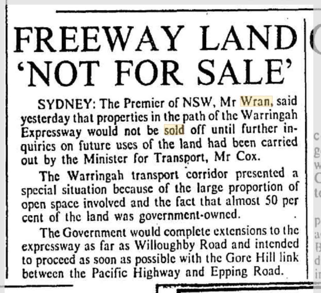
Those of us with an eye to history remember that it was the Wran Labor government who left a ruinous legacy of flogging off road corridors for the M4 and elsewhere in 1977.

Now, taxpayers are left with multi-billion dollar bills for projects like Westconnex, or the north-west rail link – made ridiculously more expensive precisely for the lack of some bold, long term planning decades ago.
But lest you think that I am mounting a defence of wall to wall freeways – think again. Sydney needs a coherent mix of road and public transport networks.
We need to avoid “Los Angeles-isation” of our city. But if this infrastructure barely keeps pace with an eternally growing population, it merely creates the illusion of progress while we actually go backwards in terms of our quality of life, sustainability outcomes, and commute times.
It alarms me that none of our leaders are prepared to ask the question “When will Sydney be full”? It’s a simple enough question, and shouldn’t be heresy.
I’ve used Dick Smith’s compelling documentary “The Population Puzzle” with my students.
It alarms me that Sydney is growing without any leadership on the question of what it’s maximum population should be.
I believe that Australia’s sustainable future lays with both limiting population growth, and providing sharper incentives for decentralisation – sending demand outside of our capital cities. we need to have a period of consolidation in Sydney, so that our infrastructure can finally catch up. People are very angry about this, and it may prove decisive at the next State election.
however, that's a huge topic which I’ll say more about in another video.
Point 2: We’ve all been here before
Confession: If this begins to sound like a history lesson, it’s because I am a qualified history teacher. But indulge me; because it’s really important to understand some historical context, so we can understand why this kind of thing keeps coming up.
I only need to pick one small part of the Hawkesbury to illustrate in microcosm what happens when governments suffer from these repeated thought bubbles and then ride rough-shod over the community.

Back in 1948, there was a master blueprint for Sydney called the “County of Cumberland” plan. It understood that a healthy city contained a dense core, a ring of urbanised suburbs, and most importantly, green belts that served the city with recreational spaces, productive agricultural land, wildlife preservation and visual amenity.
It was a great idea. And it didn’t last. Sydney wide, the pressure for growth at any cost gradually eroded the green belt idea.
All the land in our neck of the world was farms and rural properties. And the land now next to the proposed M9 corridor, is Scheyville National Park. It was gazetted in 1996. But before it was a National Park, it was one of the largest contiguous parcels of crown land left in the Sydney basin. Which is why, by turns, various governments, Labor and Liberal, state and federal, if I might paraphrase HG Wells, “looked upon us with envious eyes, and slowly, they drew their plans against us”
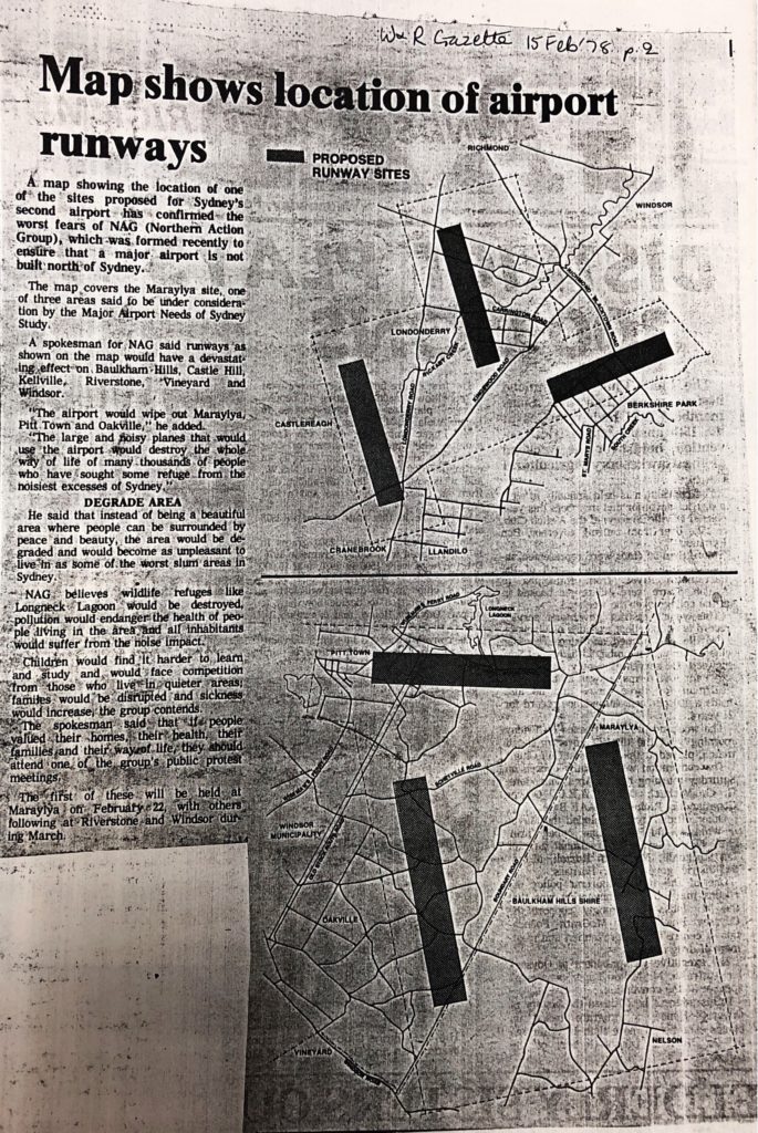
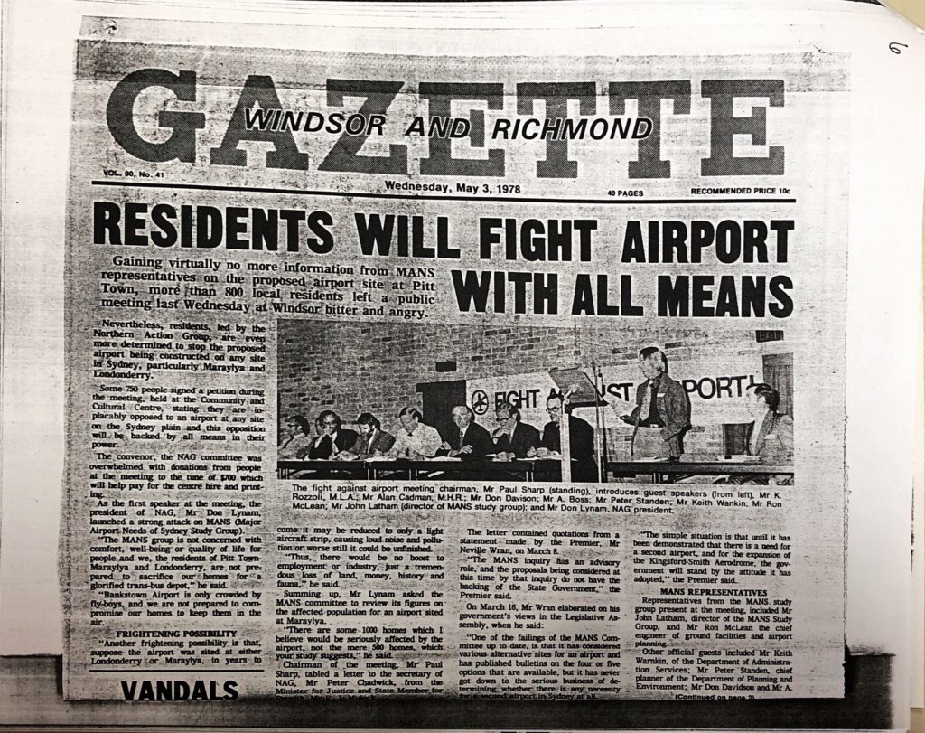
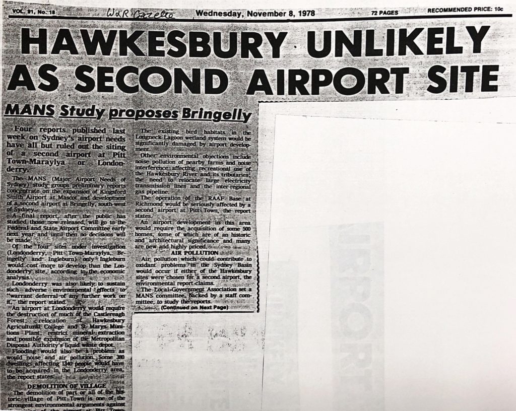
In 1978, there was a serious proposal to make Scheyville and Pitt Town the site of Sydney’s second airport.

This bubbled away for years. One of my earliest memories, and a kind of political birth for me, was seeing this map of the proposed locations of the runways.
My home at Oakville was underneath one of them. The irony that these airport runways now also lay directly beneath the path of the M9 shouldn’t escape us.
The proposal created uncertainty and dread just like we’re seeing today.
I think it’s significant that, by 1983, the State, Liberal member for Hawkesbury, Kevin Rozzolli, was prepared to speak out strongly on behalf of his constituency. He said:
“Mainland Australians are concerned at the environmental damage that may occur should the Franklin Dam be constructed in Tasmania.
The same people should be concerned about consideration of the siting of an International Airport in the area… variously described as Nelson, Box Hill, Rouse Hill, Maraylya, Oakville and Pitt Town”
“The major factor is not technical feasibility… but whether such construction will so alter the character of the area in which it is located that it will destroy forever a part of Australia’s heritage, a heritage at least as priceless as the Tasmanian wilderness”

I'll underline that: Our State Liberal member was prepared to liken the natural and historical heritage of Oakville, Maraylya and Pitt Town as analogous to that of the Franklin river in Tasmania. He went on:
“The natural endowments of the area which have created the unique circumstances of its history, scenic beauty and quality of life, demand its preservation as part of Australia’s heritage”.
That heritage is still relevant today.
Dominic? I am calling for you to show the same conviction that your predecessors have.
Let’s move on. In 1987, the same site was announced for a massive, maximum security prison, bigger than Parramatta gaol.
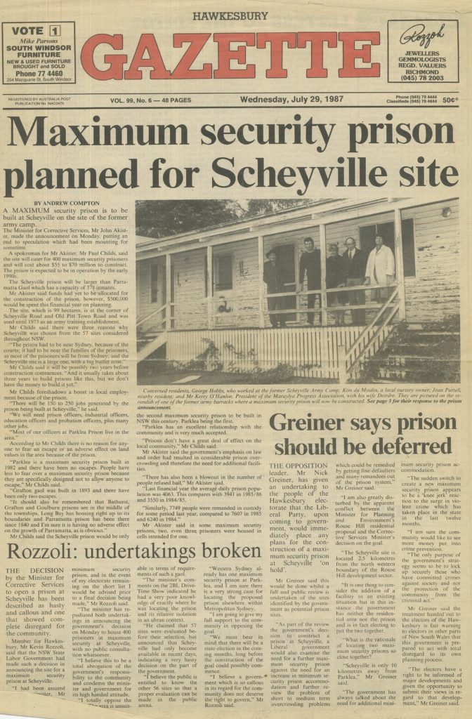
Again, the local Liberal state member for Hawkesbury was in the vanguard in condemning the idea, saying
“I am going to give my full support to the community in opposing this gaol”
In 1991, the Government announced that Scheyville was at the top of a list of preferred sites for a what would have been the largest rubbish dump in the southern hemisphere.
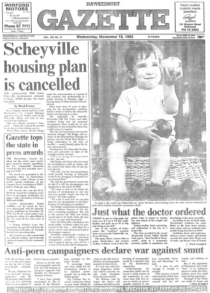
In 1992, the government announced that the same area would be the site for a massive housing development. Hawkesbury Council issued a prospectus that showed bushland at Oakville and Scheyville bulldozed and replaced with a new suburb of 20,000 people, complete with four new primary and high schools, and urban runoff draining straight into Longneck creek.
So, my point? We’ve all been here before. There's nothing new under the sun.
But also: People power can win!
Each of these proposals, presented in most cases as necessary and inevitable, were knocked on the head by the community rallying to make the government see sense.
The airport idea was scuttled.
The dump didn’t happen. The prison idea went the same way

And the plans for a massive new suburb? Stopped cold.
And eventually – we got the land around Scheyville gazetted as a new national park. I was 22. It was the year after I first stood for Council. I played a small role in that fight, and I’m kinda proud of it.
You’ll note that I’m not political point scoring here: These rotten ideas were proposed by both Labor and Liberal governments alike.
What matters is people standing up and demanding that their leaders listen to them.
The point of this history lesson is this: People can make a difference, and governments can be made either to see the light or feel the heat.
In the second video, I’ll be listing the reasons why this particular proposal isn’t good enough, and suggesting some alternatives. I hope you'll join me.

Hawkesbury City Councillor Zamprogno interviewed on Hawkesbury Radio on corridor reservations
I was pleased to be invited by Gary Cotter from Hawkesbury Radio today and talk to him about the State Government's announcements of land reservations for both the Castlereagh corridor (Bells Line of Road) and the Outer Sydney Orbital (M9) corridor.
Both these announcements may have substantial impacts on the Hawkesbury. On the one hand, governments should be praised for forward, generational thinking. On the other hand, their claim that the chosen locations were based on extensive community consultation is completely false.
Listen along to the interview (<14min) and tell me what you think. There will be much more to say about this soon!
https://soundcloud.com/nathan-zamprogno/nathans-hawkesbury-radio-interview
Is Sydney Full?

"Significantly for the Coalition government, 61.7 per cent of Liberal supporters believe Sydney is full, 28 per cent are in favour of more development and 10.4 per cent are undecided."
To those who may remonstrate with me, my question is this: So when are we "done" with development? At what threshold, even in theory, would we say "this represents overdevelopment" in Sydney, when other cities in NSW are crying out for growth and investment? When, as the article bluntly poses the question, is Sydney "Full"? As a teacher, I've looked at this with my students, and I focused a unit of study on population around Dick Smith's excellent documentary The Population Puzzle. It's required viewing for anyone genuinely concerned about this issue.
As a local government representative, it concerns me that our ability to even contribute to that debate on your behalf is slowly being eroded by an increasing centralisation of planning controls, gravitating towards the Planning minister and panels of unelected bureaucrats. Many decisions that Councils used to make are being taken out of our hands. The reduction in local democracy is alarming.
Yet, my Liberal colleagues counter, this is because the decisions that many Councils make, including our own, are grossly inconsistent with the established planning guidelines. The substantial time and money invested by people seeking permission to do, legally, what they ought to be able to do with their land is subjected to the caprice and thought-bubbles of quixotic Councillors. Some of the decisions taken by our Council in the last year baffle me. Regretfully, the rank situation in Councils like Auburn, where developer Sam Mehajer brought the whole process of local government into disrepute, has caused all Councils, including our own, to be tarred with the same brush, and to be subjected to the same extreme corrective measures.
Again, both views represent facets of a larger truth.

Consistent inconsistency from Council regarding development
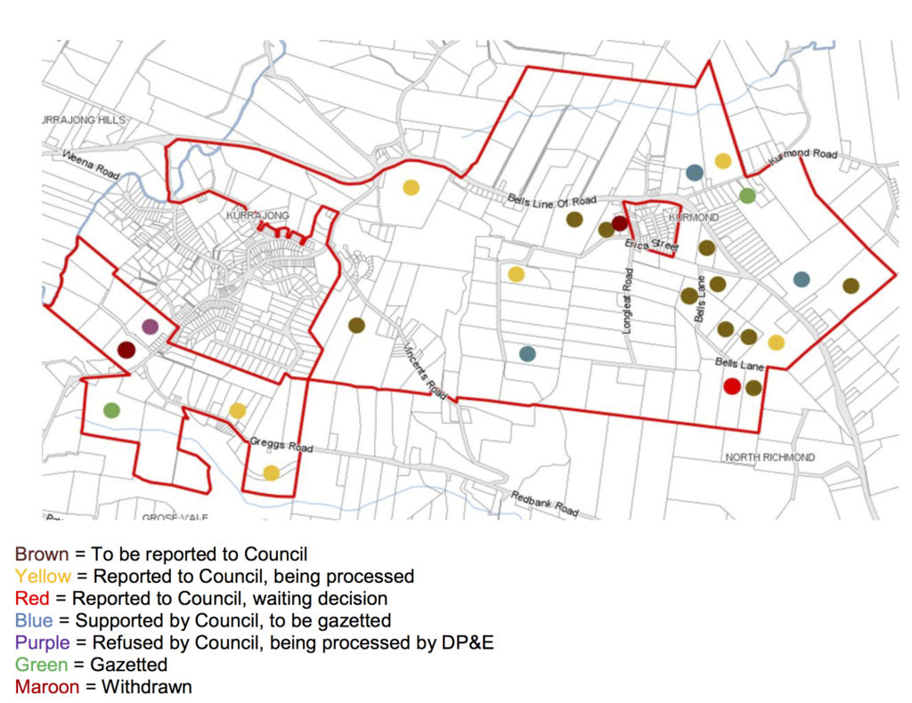
Today, the Liberal Hawkesbury Councillors issued a media statement to express their concern about the current Council’s inconsistent attitude to development in the Hawkesbury. This post is intended to provide more information on our position.
On the 29th of November last year, Council voted to receive a report into the “Kurmond and Kurrajong Investigation Area Survey”. The matter was on the agenda in the last days of the previous term, but they punted it to us to allow the new Council to consider the report and take whatever action we saw as necessary.
This report sought to inform Council of the clear wishes of the residents of Kurrajong and Kurmond concerning the scale and form of development that they preferred. The summary of the report declared:
“Overall, the results of the survey showed that there was more interest in large lot residential/rural- residential development throughout the Investigation Area than for further residential development, particularly within the existing villages of Kurmond and Kurrajong. There is some support for large lot residential/rural-residential development and residential development immediately surrounding the village of Kurrajong and large lot residential/rural-residential development and residential development immediately surrounding the village of Kurmond”
The results were clearly tabulated, looking (in part) like this: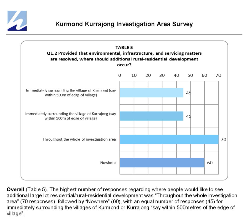
The recommendation that came to Council from staff said
- Council receive the results of the Kurmond and Kurrajong Investigation Area Survey.
- Council Staff identify a number of specific areas (based upon Constraints Mapping, survey results and the preferred approach as outlined in this report) for possible development of additional large lot residential/rural-residential development throughout the Investigation Area and some residential development up to, but not within, the existing villages of Kurmond and Kurrajong.
- The identified areas be further consulted with the community regarding future development.
- The results of that further consultation be reported to Council."
At the prompting of Labor councillor Amanda Kotlash and Greens Councillor Danielle Wheeler, the following two items were added to the motion:
5. Council not accept any further planning proposal applications within the Kurmond and Kurrajong investigation area until such time as the structure planning as outlined in this report is completed. Council receive a progress report on the structure planning prior to July 2017.
<
p style="padding-left: 60px;">6. Council continue processing the planning proposals within the investigation area that have received support via a Council resolution to proceed to a Gateway determination and any planning proposals currently lodged with Council as at 29 November 2016.
Mayor Lyons-Buckett recused herself as her own home is in the investigation area, and the motion was passed 10:1, with Clr. Rasmussen the only dissenter.
During the debate, it was clear that there were several reasons why the motion could be supported in a broad and bipartisan fashion.
The first reason was because there was an acknowledgement of the broad purpose of the Investigation Area process. The initiating Mayoral Minute in February 2015 identified the need for “Implementation planning for the Hawkesbury Residential Land Strategy (RLS)”, and “the need to undertake structure planning and development contribution planning for development areas.”
My worthy colleagues on Council frequently cite an epidemic of ad-hoc development as the reason for slamming on the brakes, as though the Hawkesbury is sleepwalking into a Rouse-Hill style densification without a broader appreciation of the physical and social infrastructure required to make those communities accessible, sustainable and in keeping with the semi-rural qualities we value highly in the Hawkesbury.
I'm on the record myself as being uncomfortable about the pace of residential development in the LGA, but the key difference is that I respect the need for the proper planning processes to establish what should and shouldn't happen in various parts of our city.
The motion that the Green and independents willingly sponsored acknowledged just this: That this was a well-conceived process of asking the residents of Kurrajong and Kurmond what they wanted, and then proceeding to identify the large-scale and long-term resource allocation and planning work that would need to be done, and then reporting back to Council.
The proof that this was the case is in the brief that was given to Council staff. They were to formulate:
- What land may be suitable for large lot residential / rural residential development
- What land may need to be protected or conserved (e.g. land containing threatened species or endangered ecological communities, riparian areas, land with significant slope, significant view lines)
- The nature and location of future development (e.g. the type of residential development and minimum lot size requirements)
- Likely development yield and take up rate
- The extent of rural village expansion and limits to growth
- The nature and location supporting public infrastructure (e.g. roads, intersections, drainage infrastructure, community facilities, parks and recreation facilities)
- Mechanisms to fund and provide supporting public infrastructure.
And they gained concurrence from local residents that the planning principles that should be adhered to should prioritise:
- Essential services under the Hawkesbury Local Environmental Plan 2012 and fundamental development constraints are resolved.
- Building envelopes, asset protection zones (APZs), driveways and roads are located on land with a slope less than 15%.
- Removal of significant vegetation is avoided.
- Fragmentation of significant vegetation is minimised.
- Building envelopes, APZs, driveways and roads (not including roads for the purposes of crossing watercourse) are located outside of riparian corridors.
- Road and other crossings of watercourses is minimised.
- Fragmentation of riparian areas is minimised.
- Removal of dams containing significant aquatic habitat is avoided."
These are precisely the issues that the green-independent Councillors are obstructive over now, so of course it made sense in November for them, and us (the Liberal Councillors) to support this process.
However, the second reason that the motion drew broad support was, crucially, that it granted procedural fairness to applicants who had begun, and in many cases, were well along in the process of submitting planning proposals or development applications that were consonant with the kind of development that the report identified as desirable by the communities of Kurrajong and Kurmond! Look at point six: Any application lodged before the 29th of November and which had earlier been supported by a Council resolution, or anything lodged in the system before that date would “continue to be processed”. This meant that the Greens, the Mayor, the independents – all of us that voted for the motion, accepted that the only fair and consistent policy to enact would be to continue to see existing applications move through Council, and proceed to Gateway Assessment (the “higher up” review of planning proposals by the NSW Department of Planning, who are also cognisant of the “bigger picture” issues relating to roads, utilities and sustainability).
It was regarded as fair that, seeing as the clear preference of the new Council was to disfavour development west of the river, that new applications be put on hold. And it was equally understood as fair that procedural fairness be granted to planning proposals “in the pipeline”, not that there were even very many of them (see map at the header of this post). Many families with larger acreage holdings had entered into the expensive process of seeking approval for large lot subdivisions (~4000m²) in good faith. Council is entitled to indicate a new direction for new applications, but it is not entitled to cut off applications already in the system at the knees.
Sadly, this agreement has not been honoured, and the Green and Green-aligned Councillors have reneged on the processes that they themselves seconded and supported in the Chamber.
Since the 29th of November, a number of extant planning proposals that met the criteria of the Kurmond/ Kurrajong Investigation Area have come to Council and been repeatedly knocked back for reasons unrelated to their individual merit, demonstrating a complete inconsistency with Council’s resolved position in November. I and my fellow Liberals have remonstrated with the Greens and Independents, and I might say, have frequently been supported by the Labor Councillors Amanda Kotlash and Deputy Mayor Barry Calvert. In this new Council, on this matter, the “establishment parties” represent professionalism and respect for process, and the green-independent Councillors represent stumbling, amateur opportunism.
One Councillor disputed factual assertions by Council staff, claiming his half hour of Googling on the question of the capacity of waste water recycling systems trumped the considered data put forward in the business paper. As a result, one applicant will have to install a second water treatment system for a single residence that currently has an occupancy of four. Cost: many thousands of dollars. Another Councillor barely manages to stay awake, punctuated by repetitive and irrelevant lines of questioning. Another Councillor admits their ideological “never, ever” predisposition to evaluating all proposals, and in seeming disregard of any evidence put forward. This isn't government by the deliberative consideration of the evidence. This is government by ingrained bias and thought-bubble.
Now I hasten to say that I enjoy the fraternity of my Councillor colleagues, and also with Council staff. We get genuinely along, despite our differences of opinion, and I value that we generally treat each other with respect. However, we’re not there to agree on everything, and if I think our community is ill-served by this kind of inconsistency, I’ll call it out.
Today, our Mayor has tried to refute the idea that the Council is opposed to “any development west of the river”. In support, she states that 74 DA’s were approved by Council in the last month, with 45 of them west of the river, and 29 east of the river. This is a little disingenuous, considering a DA can be anything from a shed to a building extension, and that most of these DA’s were approved by staff under delegated authority.
A better measure is to look at the growing list of inconsistent decisions that would otherwise have been covered by Council’s resolution of 29 November.
On the 29th November 2016, Council considered a planning proposal for 431 and 431a Greggs Lane, Kurrajong. It was an 8 lot subdivision, each lot being no smaller than 4000m². It fell within the investigation area that Council had only moments earlier voted to continue to process extant applications for. Yet Council voted to defer. Then, on the 13th December they voted to approve, and again on the 11th April 2017, voted to continue the process.
Fine, so far. Their attention span held. But look what’s happened since:
31st January: 42 Bells Lane, Kurmond. 4 lot subdivision. Voted down.
31st January: 98 Bells Lane Kurmond, voted down.
14th February: 42 Bells Lane Kurmond (via Rescission motion). Defeated again.
11th April 2017: 631 Bells Line of Road, Kurmond: Voted to defer.
What was different between the Greggs Lane application and the others? Nothing. Applicant after applicant (frequently families dealing with the desire to secure retirement security, give their kids a leg-up, or dealing with deceased estates) leave the chamber shaking their heads, wondering why their application failed when similar ones were approved, and wondering why precisely none of the debate in the chamber came even close to arguing the actual merits of their proposal. Instead, they were knocked back over a general worry over "traffic", or waiting until the results of a traffic study come in that has nothing to do with their application. It's a bad signal to send to people wanting to invest in our area.
Further, what the residents of Kurrajong and Kurmond are entitled to find galling is that Council have already engaged in the process of asking you what you actually want in the area, and that the answer seems clear. Your preference is for Rural-Residential development (as opposed to Residential smaller-lot development), and the preference is for that development to be generally contigious or near the existing village centres. Despite being generally leery of development, that's something that even I can support, especially when it follows extensive community consultation.
It is disappointing to see your other elected representatives claiming that they know your minds better than you do.

About the Grose River bridge and the Redbank development

Today, I’m writing about the proposed bridge across the Grose River that forms part of the deal struck when the Redbank development was approved at North Richmond.
First, I’ll repeat something I’ve said before: If I had been on Council when the Redbank development at North Richmond was put up, I wouldn’t have voted for it. It worsens the congestion at North Richmond and across its bridge. The scale of the development was not compatible with the area, and the rural landscape created by the keyline dams scattered across the Peel property were better preserved as open space.
However, my current Liberal colleagues on Council are correct when they say that there was one thing that made Redbank compelling, and that was the provision of a new bridge across the Grose River, entirely at the developer’s expense.
I want to dispel some misunderstandings about where things are at. Councillors received a briefing on this matter just a few days ago. Our deliberations should always be led by the official reports that come to us in the lead up to a vote, but there’s incorrect information circulating in the community and the need for other tiers of government to be equally engaged with us makes this commentary worthwhile.
The Redbank developer signed what’s called a “Voluntary Planning Agreement” (a VPA) in August 2014. The VPA can be accessed here. The co-signatories were Hawkesbury Council and the RMS. The most significant obligation this VPA conferred was the provision of a “Multispan bridge, approach roads and intersections for crossing at Yarramundi of Grose River”, which would have to be approved by the time the 341st lot was sold. This threshold will be met by about March 2018, based on the current rate of lot sales.
The developer has taken out large advertisements in local papers declaring this approval is “stuck” in Council and “may take years to resolve”.

This simply isn’t true. The developer was given a choice about the mechanism by which the approval process for the bridge could proceed. They were advised about what would be required at a meeting in July 2015. They lodged a D.A. in April 2016, and then nominated to have the mechanism changed to what’s called a “Part 5” process only in August 2016. This was exhibited until September 2016 and is ongoing. There are a couple of documents outstanding, including a Crown Lands Merit Assessment. The necessary document for Approval to be considered by Council will be a revised Plan of Management, which could be available by late 2017 or early 2018 – in time for the lot threshold defined by the VPA.
It’s worth noting that this VPA also included a lot of other benefits to the community that have already been delivered, such as $2.5M to upgrade Bells Line of Road, Grose Vale Rd, the Terrace, Old Kurrajong Rd, Yarramundi Lane, Bosworth St and March St. It will also deliver 15 bus-shelters, concrete paths in Peel park, $1.35M to upgrade North Richmond Community Centre, the dedication of land with utilities for a future Child Care centre, and maintenance of all open space for five years prior to dedication of the land to Council into perpetuity. Not a bad outcome!
The developer now says that they would prefer to see a sum of $24M given over to “Council and RMS” to build the bridge themselves. But the reality is that only 5% of the money would come to Council, and that the RMS will not build the bridge with the money. RMS would be constrained to put the money towards “other improvements” to state roads between Richmond and North Richmond, but at time of writing, they have no projects to which the money could be profitably put. It is unlikely the Grose River bridge will cost only $24M to build, so why let the developer off the hook so cheaply? The developer has to supply the bridge regardless of the cost.
Similarly, there is a fantasy going about that taking this money will make a “third crossing of the Hawkesbury” happen all the sooner. This just won’t happen. The cost of duplicating North Richmond bridge is north of $200M. There is no connection at all between this bridge proposal and the widespread calls (including those of me and my Liberal colleagues) for a third crossing. It has no bearing on the merits of the now-advanced plans to replace the bridge at Windsor, and the Grose River bridge has never been advanced as being “the third crossing” that is needed. To be sure, it is a third crossing, but it’s not a crossing of the Hawkesbury River.
The developer’s advertisements make it seem like this clause to hand over money in lieu of building a bridge is something they can do unilaterally. They can’t. Nor can they "demand" that someone else build the bridge in their stead. And it’s not like the $24M is sitting in their bank account and burning a hole in their pocket. If the handover option was consented to, the money would trickle in based on future lot sales and could take over a decade to pay down. It's a bum deal, and we'd be fools to take it.
It is against this backdrop that the current political debate is unfolding. A Facebook group titled “Hawkesbury Needs a Third Crossing” seems absolutely bent on opposing the Grose River crossing, which is “a” third crossing, and that strikes me as perverse. CAWB would willingly conflate the debate about the Grose River crossing with the current plans to replace Windsor Bridge, when they aren’t even remotely related. Others will claim that because the Redbank development was a matter that came before ICAC, the whole development is “tainted”. Three of the four Liberal Councillors, including myself, weren’t even around when that was approved and as unsavoury as that episode was, the claim does nothing to negate the advantages of having the bridge built now that Redbank is a reality.
What this boils down to is that the contractual obligation to build a bridge over the Grose River is the thing, the biggest thing, that made Redbank even remotely palatable. If Council decided to knock back the bridge, it would be cutting its nose off to spite its face. It would be refusing the major community benefit that flowed from the Redbank development, and it would be making a decision for largely political reasons.
Our Mayor recently released a “FAQ” statement that repeated some of the clarifications that I’ve just laid out. These statements, bar one, were agreed to by all the Councillors as necessary to clear up the confused discussion after we were briefed on the matter by Council staff. It was not, as one facebook commenter breathlessly declared a case of “In a grubby political river of misinformation the Mayor shines a light on the FACTS!!!” Please...
The Liberal Councillors fully supported the suggestion that Council rebut some of the claims the developer put in their advertisements. However, and unhelpfully in my view, the FAQ defensively reacts to the accusation that the “Non Liberal Councillors are holding up the bridge.” Neither me nor my Liberal colleagues have made that claim. What I have said is that, from this point forward, if Council is the body which determines the fate of the bridge, then most certainly its fate lays with the non-Liberal Councillors, who are a clear majority in the chamber.
I and my fellow Liberals took support for the Grose River bridge to the September 2016 election as a key plank of our campaign. Here it is on our election handout material…

It is also true that there are other Hawkesbury City Councillors who have expressed their trenchant opposition to the Grose River bridge. I don’t name them here because it is for them to make their own public statements on their position. But make no mistake: The decision is very much in the balance! My recommendation is for members of the public to hold the feet of all Councillors, Liberal and non-Liberal alike, to the fire and to make them state their position on the bridge clear to the community. We have. It is not enough to hide behind process and say that they aren’t prepared to say anything until a report comes to Council that’s about to be voted on. This is an agreement that Council, the Developer and the RMS inked nearly three years ago to do a certain thing. There’s plenty of information in the public domain, and which they should be across. Do they support this bridge or not?
It is my view that the vast majority of Hawkesbury residents, and especially those who endure the torturous ordeal of North Richmond traffic day in and day out, can’t wait to see this bridge built. They recognise that it’s not a complete fix (it will reduce the traffic across North Richmond Bridge by over 30%), but more significantly, it’s costed, timetabled and ready to go. Hawkesbury Council is doing its own part to prepare the necessary approvals for consideration by Councillors in early 2018. Hawkesbury residents west of the river understand that the best solution, even a partial one, is one that arrives within their lifetime, and is already paid for. If the non-Liberal councillors have seen the extensive information to hand, are not prepared to back the proposal, they should say so clearly.

When development fails the common-sense test
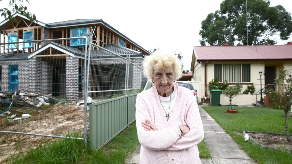
What would you think, if you lived on a pleasant suburban block, and your neighbour knocked down a modest 50's era home to build a duplex so big that it came up hard to the fenceline on both sides of the property, and parts of the building even overhung your fence?
This is the situation a local resident has faced in Teviot St, Richmond. I was concerned when I visited this site that a building of this scale was approved for a block this size. The brickwork is only about 8cm from the fence on both sides, and the gutters actually crossed the line of the property boundary.
How this kind of structure gets a tick is beyond me, and I think most readers would agree with me that this fails the common-sense test. I'm now going to take an interest in seeing if the rules Council follows for developments like this should be changed. If this building satisfied the criteria for such a development, then those codes need to change, badly!
Thankfully, the Gazette has picked up the story and my remarks on the matter can be found here.
Mrs McArthur, one of the affected neighbours, was not given any confidence when it was discovered that the private certifier has had several complaints upheld against him by the Building Professionals Board for not doing his job. At my urging, compliance action is now taking place by the Certifier and the builder, and I'll continue to take an interest.
If you have concerns about a matter like this in the Hawkesbury, please feel free to contact me.

Is the Hawkesbury a Shire or are we a City?
I still remember that when I was a kid in 1989, "Hawkesbury Shire Council" changed its name to "Hawkesbury City Council".
I wondered then, as I do now, why we bothered. It seemed a pointless gesture which worked actively against the identity most locals held about the area. I believe it sprang from an erroneous sense of inadequacy, and that we lost nothing by continuing to be known as a Shire.
Did you know the word Shire is a Saxon word, whereas County is its Norman equivalent? And a city, as our late Mayor Rex Stubbs used to explain to me, was a "town large enough to have its main church called a cathedral". Despite Rex's romantic penchant for referring to our historic St Matthew's church (this year celebrating its bicentenary!) as the "Cathedral of the Hawkesbury", I'm afraid I just don't buy it. We don't have to be a city. Let's look at some numbers.
There are (subject to the ongoing vagaries of the Council amalgamation process), presently 128 Councils in NSW. The City of Hawkesbury has a population of 66,134 (per 2015 ABS Statistics). It's just a fact that plenty of Councils bigger than us are perfectly happy to continue to be known as "Shires", even when given recent opportunities to re-name. Look at Hornsby Shire (population: 156,847), Hills Shire Council (169,872), or Sutherland Shire (210,863). The latter is three times our size, and they feel no need to "upgrade". And no-one could accuse our near neighbour in The Hills Shire for being less dynamic or future-oriented. Further, their adherence to the word Shire is not an anachronism, considering they had the opportunity to re-brand themselves as a "city" when they changed from "Baulkham Hills Shire Council" (a name in use since 1906) to "The Hills Shire Council" in November 2008. And look at that area now!
I've always held the belief that the word "Shire" was more pleasant than "City", both for its ancient linguistic roots, but also its evocation of bucolic, open spaces.
The term Shire, in our case, used to reflect the fact that we were precisely not a bustling, congested, urbanised polis. We lay... between. We were between Sydney city proper and the country. The trendy term now in use is "peri-urban", but I find this to be a little pretentious. One could speculate that Tolkien would never have used such a Newspeak word when trying to evoke his sylvan idyll. The recent process I engaged in to draft our new Community Strategic Plan underlined that what we aspire to as our identity is largely defined by our semi-rural aspect. Our mix of habitation, agriculture, and protected environmental spaces is well described with the word "Shire". The word "City" just seems to convey the opposite to me, and, considering our population and neighbours who don't use the word, makes us look more than a little self-conscious.
Should the Hawkesbury remain as a City, or go back to our old name of "Hawkesbury Shire"? I think we should, even while I acknowledge that there is probably little appetite for the change. Further, there would be the cost of changing all our signage, letterheads and other livery -- and I would absolutely oppose that needless expense while we have more important matters to attend to as we pursue long term financial sustainability as a Council.
What do you think? I'm interested in knowing.
Here's a timeline of the naming of our municipality:


The Hindu Temple at McGraths Hill
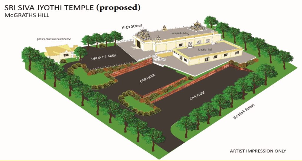
The proposal to build a Hindu temple in High street in McGraths Hill came before Council at the last meeting and was narrowly approved. The vote was tied six-all and was approved on the Mayor's casting vote. I spoke and voted against the proposal. The councillors who voted for and against the proposal are listed in the following table:
|
Voted for the Hindu temple |
Voted against the proposal |
| Councillor Barry Calvert (Labor) | Councillor Paul Rasmussen (Ind) |
| Councillor Patrick Conolly (Lib) | Councillor John Ross (Ind) |
| Councillor Amanda Kotlash (Labor) | Councillor Emma-Jane Garrow (Ind) |
| Councillor Lyons-Buckett (Ind) | Councillor Peter Reynolds (Ind/Labor) |
| Councillor Sarah Richards (Lib) | Councillor Danielle Wheeler (Greens) |
| Councillor Tiffany Tree (Lib) | Councillor Nathan Zamprogno (Lib) |
There is no doubt that this matter has been divisive, and I am aware of the strength of feeling that was expressed at the meeting from the gallery and on social media. However, my job was to examine the application before me and to consider it on its merits.
Tonight, I had the opportunity to attend a public meeting at McGraths Hill where the community expressed its frustration at the approval of a development with so many flaws. Only one other Councillor, Clr. Ross, was present.

I felt quite proud of the civility with which people spoke. These were ordinary people-- tradies, retirees and professionals, voicing well-thought-through concerns about their perception of deficiencies in leadership and of process at Council. Neither race nor religion were mentioned, nor was any bigotry manifested. The most common sentiment expressed was "great idea, wrong spot". Frankly, apart from a very small minority of noisy online ranters who were not even present at the meeting tonight, the stereotype of "objectors as racists" was completely disproven.
This post does not intend to prosecute the argument for or against the development, nor to reflect on my worthy colleagues who were entitled to vote as they chose. We differed in opinion-- and were entitled to. This is the process we engage in.
However, I will say that the purpose of this website is to communicate with the community. Each Councillor must account for the stance they have taken to their electorate, and I was glad to be able to stand among local residents and answer to them. A recording of my (brief) remarks are below:
About the Redbank development at North Richmond

Last Tuesday was the first public meeting where we new councillors addressed regular council business. It went from 6:30pm until well after midnight, owing to the backlog of matters created by the election, and a helping of deferred matters gifted from the previous council.
I remarked at the meeting that this was a baptism of fire, as immediately before us was arguably one of the most contentious issues facing the new council: The Redbank development at North Richmond. The specific item before us on Tuesday were ten blocks in an area called "The Gallery" which back on to the RSL Retirement village. The retirement village residents objected that they had secured their houses in the belief that the land behind them would be left as empty space. They also objected on the grounds privacy, drainage and noise, given that the land slopes upward behind them and a retaining wall has been constructed.
The previous week I had inspected the site and, despite arriving unannounced, the site manager Scott was gracious in receiving me and showing me around. I also spoke to various residents living in the RSL village in Catalina Avenue, who showed me the promotional material the RSL offered them. It did indeed show a layout of the Redbank site with the land in dispute left open-- such as the image at the header of this post.
The recommendation from Council staff was to approve the subdivision -- or rather to ratify it, since we were told that the blocks had been sold and the new owners were waiting to build. I was informed that the original approval body of this part of the subdivision was not Council, but a State body called the JRPP (Joint Regional Planning Panel), who take planning decisions out of the hands of Councils if the value of a development is over $20 million.
Meantime, the deferral of this matter by the previous council was taken as a deemed refusal and the developers had commenced litigation in the Land and Environment Court. If the litigation proceeds, legal costs could be considerable to council.
I expressed my anger at the meeting that the JRPP did not take up the issue of why the development they were asked to approve in early 2014 was at such variance with the prospectus offered RSL village purchasers. The village residents have every right to be aggrieved that the material was misleading. My understanding is that the RSL have acknowledged this and have offered the residents the option to move and gain a refund. But surely this is cold comfort for many of those residents who have considerable sunk cost in their new homes and who probably regarded their last move of house as their last.
To determine who has perpetrated a deception on whom is not simple. I believe the testimony of the residents when they say that they were given an indication that the land would be open, both in terms of the brochure they showed me, and verbally. I disagree with the statement in the Council business paper which says
"Investigation from Council staff has not found evidence that sales person's advice had made this claim [that the land would be left open]"
However, on the other side, there are other factors which should be taken into account:
- The land was always zoned for potential subdivision, and the residents should have known that this was a permitted and likely use of that land when they bought adjacent to it.
- The residents bought-in after the Redbank development was approved (I'm awaiting definite dates here, but the developer says the JRPP approved it in early 2014 and the date one resident quoted me for their settlement was August 2014), and their solicitor could have found out the subject land was sub-dividable (but there is the legitimate riposte that they had received a verbal undertaking that the land would be free and did not think to check).
- The material which misled them was produced by RSL Lifecare, and the developers of the subject properties on Tuesday's D.A's are an unrelated party, and that recourse should be made by the RSL.
- That a complaint was made to Fair Trading about the deceptive promotional material, but that at this stage, the claim has not been upheld. I disagree, and would encourage the residents to pursue those avenues of appeal that Fair Trading indicated.
- That the developer's right to build on the lots approved by the JRPP is probably strong and a court case will be unlikely to negate it, but will be costly.
After balancing these concerns, I voted to approve the subdivision, but remarked that we metaphorically had a gun to our heads. I wasn't happy about it, but felt we had to do it. I didn't believe deferring or refusing it would alter the outcome, as regrettable as it is for the residents of Catalina avenue.
I am heartened, however, to hear that related issues concerning noise, drainage, and the screen planting between the fence and the retaining wall are all matters the developer is still happy to address with the residents as the matter comes to conciliation in the court.
The residents are entitled to think that the whole system has failed them. From their perspective, the RSL misled them and offered a remedy unpalatable to them. The JRPP should have been where the difference between the RSL prospectus and the developer's request were questioned, but weren't. The matter was dumped in the old Council's lap and then deferred to the new Council, who have again deferred it.
If the entirety of the Redbank decision had been mine to make years ago, I would have said no. However, that is a whole other question. On Tuesday, I was focused on the application before me, and nothing else.
As one of my worthy colleagues said during the meeting: "This is an example of how not to do things". I agree.